I think we had to discuss here - how and where to travel.
When you plan to travel more abroad at sample on the silk road or crossing africa - a normal road based map would be not that helpful.
Pretty easy is a Ipad based (offline) solution:
Ipad for Road Navigation
Ipad for Offroad Navigation (Bing Satellite & Hybrid Map)

There is GPS-Device arround who can top such a setup.
Also when you had a much stronger solution with a windows based tablet - it is not easy to optain satellite Images for offline usage at sample.
With a Windows Device you have more tools for navigation, but you had to spend more time to "learn" how to do it. With the Ipad it is pretty easy.
You can also use your Ipad as USB Stick and swap Files between your devices: use your Ipad as Storage
This works with any iPad with 3G and also with any iPhone. If you travel with an iPad (normal/mini) - you can use your iphone as failover device.
We had used this setup for our transafrica - and it had worked well! We had downloaded for the whole route the bing satellite hybrid imagery from Zoomlevel 3-14. Hybrid means that it is the satellite view with also the roads layer.
Some get the cheaper non 3G iPads and use external GPS devices.. You can do that but it is not necessary. We had used the 3G Version.
Actually you can Download Google, Bing Navtec (Nokia Ovi) and many more sources...
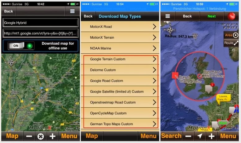
Here you find too a short walkthrough at HuBB: http://www.horizonsunlimited.com/hub...atellite-72663
Surfy
Last edited by Surfy; 16 Oct 2013 at 18:52.
|


 1Likes


 Threaded Mode


