 1Likes 1Likes
-
 1
Post By navalarchitect
1
Post By navalarchitect
 |

12 May 2016
|
|
Registered Users
Veteran HUBBer
|
|
Join Date: Aug 2005
Location: Calgary AB
Posts: 1,028
|
|
|
Africa Road Atlas - Any Good?
So I've ordered the Africa Map Atlas by MapStudio which is a South African company and overlaid a page of their atlas to some aerial imagery and there was no road/ route in sight.
What's at fault here? The map or the imagery?
Anyone used this atlas on their travels? How was it?
|
12 May 2016
|
|
Registered Users
Veteran HUBBer
|
|
Join Date: Aug 2012
Location: Australia
Posts: 1,131
|
|
Lots of things to go wrong with here.
"some aerial imagery"? How old is it? What resolution does it have? Is the road newer than the imagery?
- Dirt Roads
Many roads in Africa (and other places) are dirt ... that can make them very hard to pick out.
- Forested Areas
Where there is heavy tree cover .. roads can be covered by the tree canopy.
Africa is a large place, you would need to give some idea of where your talking about to get a better response. Have you tried OSM to see what they have? e.g printable OSM Make - Field Papers
|
12 May 2016
|
|
Registered Users
Veteran HUBBer
|
|
Join Date: Jun 2013
Posts: 137
|
|
|
Speaking of Africa maps, can you typically purchase them anywhere when you're actually in the country? Maybe better luck in some countries rather than others?
|
12 May 2016
|
|
Lifetime Member
Veteran HUBBer
|
|
Join Date: Sep 2009
Location: Australia
Posts: 367
|
|
|
I only saw a few for sale and these were in capital cities by which time you are typically
Sent from my SM-P350 using Tapatalk
|
12 May 2016
|
|
Lifetime Member
Veteran HUBBer
|
|
Join Date: Sep 2009
Location: Australia
Posts: 367
|
|
|
Try again. Thick fingers trouble on a tablet. Meant to continue and say:
By which time you are typically half way through the country. I'd buy them before you go. For what it's worth I had the two Michelin maps covering the south and NE of the continent, plus maps of each country I was visiting and it turned into a large bundle. Doing it again I'd just take the two Michelin for general planning and rely on the OSM maps I also carried on my tablet for getting more detail of a particular area. Maybe not quite as convenient but still very practical.
Sent from my SM-P350 using Tapatalk
|
12 May 2016
|
|
Registered Users
Veteran HUBBer
|
|
Join Date: Aug 2005
Location: Calgary AB
Posts: 1,028
|
|
|
Or just scan them in and take them all.
Sent from my SM-G920W8 using Tapatalk
|
12 May 2016
|
|
Registered Users
Veteran HUBBer
|
|
Join Date: Aug 2005
Location: Calgary AB
Posts: 1,028
|
|
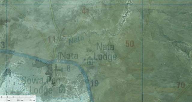
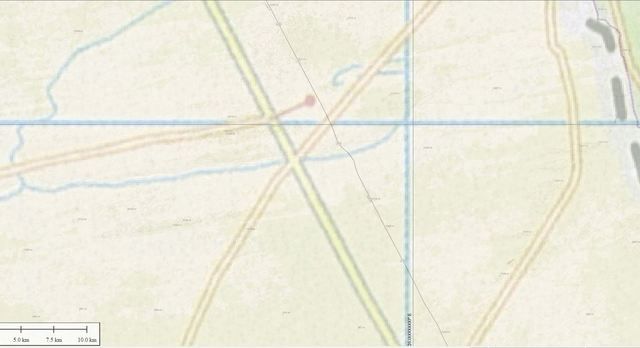
I'm not sure on the age of the photo. I'm using Global Mapper which is a licensed software with databases built in. It's in their interest to have up to date data on there, so I'm going to assume it's recent. I've compared it to Google Earth and it matches road infrastructure including dirt roads. Their imagery for this area is from 2013.
Below are some comparisons to the various data that I can use to compare. This is in Botswana, so not really that far afield from the cartographers.
Below some overlays on top of the Atlas mapping. The other sources have been made 25% transparent.
Openstreetmap
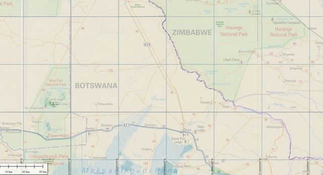
Mapquest
World Topo
World Imagery
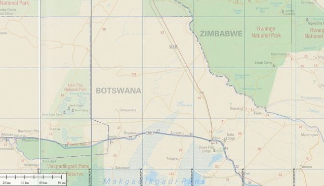
It needs a good look, but the database data doesn't include the smaller roads (at this scale). They all show the A33 and the A3 but no dirt roads that the Atlas shows. However, the resolution increases at smaller scales. So below are some further details at a smaller scale.
The Atlas is way of the track in that way near the population centre of Nata.
Openstreetmap lines up perfectly with the aerial imagery at so I haven't shown it here at the Nata area.
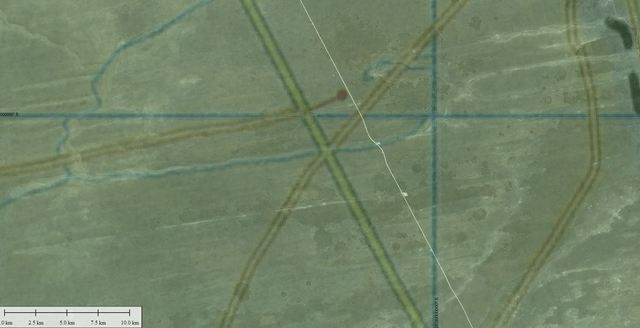
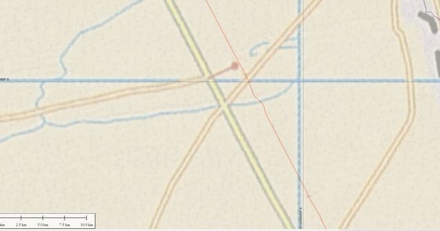
Looking at an area north of this along the A33 the Atlas show quite a bit of infrastructure. But none of the other data does. Doesn't fill me with a lot of confidence on this Atlas.
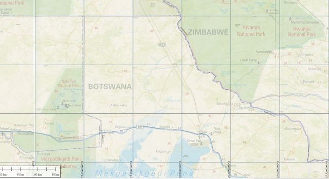
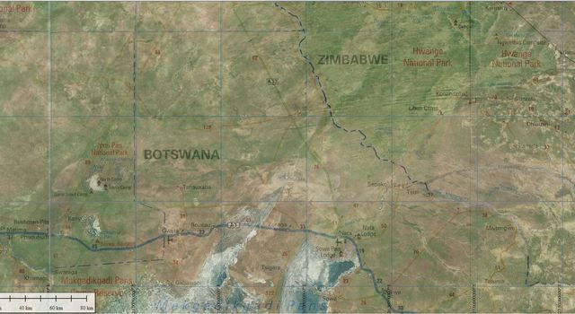
World Imagery Zoomed in at Nata
World Imagery Zoomed in at a cross roads along the A33
Openstreetmap
Mapquest
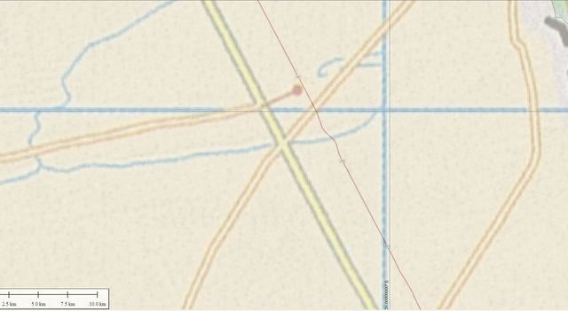
World Topo
|
13 May 2016
|
|
Lifetime Member
Veteran HUBBer
|
|
Join Date: Sep 2009
Location: Australia
Posts: 367
|
|
|
Not directly related to the original question about the alas, but I'll note I used OSM maps exclusively on my GPS and tablet all the way up the easy side of Africa and found they worked extremely well with no major discrepancies in either big cities or on back roads (OK, there was one I've just remembered where it wanted me to make a 300 km detour. I worked out it was because their database said a ferry was passenger only and not vehicle capable)
Sent from my SM-P350 using Tapatalk
|
21 May 2016
|
 |
Registered Users
Veteran HUBBer
|
|
Join Date: Nov 2008
Location: Cape Town - South Africa
Posts: 114
|
|
|
Map studio make good maps - have been using for some time.
Trust the map.
__________________
To those who say it can't be done - stand aside for those who are already doing it.
|
21 May 2016
|
|
Registered Users
Veteran HUBBer
|
|
Join Date: Aug 2005
Location: Calgary AB
Posts: 1,028
|
|
|
Thanks but that's not an argument for. I've emailed them on it but still haven't heard back.
Sent from my SM-G920W8 using Tapatalk
|
22 May 2016
|
 |
Contributing Member
Veteran HUBBer
|
|
Join Date: Jan 2004
Location: Munich, the beer capital
Posts: 1,064
|
|
|
A good address is "Tracks4Africa". Even Garmin offers map data of Southern Africa, which shows many roads as far north as Tanzania.
__________________
Only when we pause to wonder
do we go beyond the limits of our little lives.
(Rod McKuen)
|
22 May 2016
|
 |
Contributing Member
Veteran HUBBer
|
|
Join Date: Oct 2006
Location: Switzerland
Posts: 112
|
|
|
I use Tracks4Africa on my GPS and the Paper Maps from Reise Know How. Good, understructable material and mostly quite accurat.
Greets Claudio
Summer 15: North America from East to West; Winter 15/16: South Africa to Kenya and back; Spring 16: Kashmir
__________________
-Challenge your Limits-
|
23 May 2016
|
 |
Registered Users
Veteran HUBBer
|
|
Join Date: Jun 2011
Location: Originally London. Now driving my Toyota.
Posts: 191
|
|
|
As above for us T4A and paper including the Africa road atlas.
Plus we bought a SD card from UK Ebay with all of Africa on it to plug into our usual European Garmin...we have been shocked at how good it is!!! Even brings up dirt roads and real out off the way places...All for £15!!!
Covers almost every African country.
__________________
Facebook " Kevin Heike " come and say Hello as we travel around the world.
|
23 May 2016
|
|
Registered Users
Veteran HUBBer
|
|
Join Date: Aug 2005
Location: Calgary AB
Posts: 1,028
|
|
|
I've got the t4a app as well as the paper maps for Namibia and South Africa. Then the Michelin maps for Africa and the road atlas. I know how t4a gets its data which is great. The Michelin is only good for the main routes and an overview but got the atlas for a higher resolution. Now I'm scrutinizing it against other sources and it's falling short as the images before shows.
Keen to hear of examples of people using it on secondary and tertiary routes. If you have a route to show I'm keen to test my comparison as well.
So far the company isn't letting me know their sources or methods.
Sent from my SM-G920W8 using Tapatalk
|
24 May 2016
|
|
Registered Users
Veteran HUBBer
|
|
Join Date: Mar 2006
Location: Switzerland
Posts: 232
|
|
|
I found the Michelin maps very convenient and sufficient for the most part. They're not very detailed, which is great because in Africa things change very quickly, so the most detailed maps would probably be outdated by the time they're printed.
T4A is awesome for Southern Africa, useless for the rest of the continent : OSM is often better, and actually quite useful and accurate in the most unlikely places. Plus the price is right..
Laurent
|
|
Currently Active Users Viewing This Thread: 1 (0 Registered Users and/or Members and 1 guests)
|
|
|
 Posting Rules
|
You may not post new threads
You may not post replies
You may not post attachments
You may not edit your posts
HTML code is Off
|
|
|
|

Check the RAW segments; Grant, your HU host is on every month!
Episodes below to listen to while you, err, pretend to do something or other...

2020 Edition of Chris Scott's Adventure Motorcycling Handbook.
"Ultimate global guide for red-blooded bikers planning overseas exploration. Covers choice & preparation of best bike, shipping overseas, baggage design, riding techniques, travel health, visas, documentation, safety and useful addresses." Recommended. (Grant)

Led by special operations veterans, Stanford Medicine affiliated physicians, paramedics and other travel experts, Ripcord is perfect for adventure seekers, climbers, skiers, sports enthusiasts, hunters, international travelers, humanitarian efforts, expeditions and more.
Ripcord Rescue Travel Insurance™ combines into a single integrated program the best evacuation and rescue with the premier travel insurance coverages designed for adventurers and travel is covered on motorcycles of all sizes.
(ONLY US RESIDENTS and currently has a limit of 60 days.)
Ripcord Evacuation Insurance is available for ALL nationalities.
What others say about HU...
"This site is the BIBLE for international bike travelers." Greg, Australia
"Thank you! The web site, The travels, The insight, The inspiration, Everything, just thanks." Colin, UK
"My friend and I are planning a trip from Singapore to England... We found (the HU) site invaluable as an aid to planning and have based a lot of our purchases (bikes, riding gear, etc.) on what we have learned from this site." Phil, Australia
"I for one always had an adventurous spirit, but you and Susan lit the fire for my trip and I'll be forever grateful for what you two do to inspire others to just do it." Brent, USA
"Your website is a mecca of valuable information and the (video) series is informative, entertaining, and inspiring!" Jennifer, Canada
"Your worldwide organisation and events are the Go To places to for all serious touring and aspiring touring bikers." Trevor, South Africa
"This is the answer to all my questions." Haydn, Australia
"Keep going the excellent work you are doing for Horizons Unlimited - I love it!" Thomas, Germany
Lots more comments here!

Every book a diary
Every chapter a day
Every day a journey
Refreshingly honest and compelling tales: the hights and lows of a life on the road. Solo, unsupported, budget journeys of discovery.
Authentic, engaging and evocative travel memoirs, overland, around the world and through life.
All 8 books available from the author or as eBooks and audio books
Back Road Map Books and Backroad GPS Maps for all of Canada - a must have!
New to Horizons Unlimited?
New to motorcycle travelling? New to the HU site? Confused? Too many options? It's really very simple - just 4 easy steps!
Horizons Unlimited was founded in 1997 by Grant and Susan Johnson following their journey around the world on a BMW R80G/S.
 Read more about Grant & Susan's story
Membership - help keep us going!
Horizons Unlimited is not a big multi-national company, just two people who love motorcycle travel and have grown what started as a hobby in 1997 into a full time job (usually 8-10 hours per day and 7 days a week) and a labour of love. To keep it going and a roof over our heads, we run events all over the world with the help of volunteers; we sell inspirational and informative DVDs; we have a few selected advertisers; and we make a small amount from memberships.
You don't have to be a Member to come to an HU meeting, access the website, or ask questions on the HUBB. What you get for your membership contribution is our sincere gratitude, good karma and knowing that you're helping to keep the motorcycle travel dream alive. Contributing Members and Gold Members do get additional features on the HUBB. Here's a list of all the Member benefits on the HUBB.
|
|
|


 Linear Mode


