 5Likes 5Likes
 |

26 Sep 2020
|
|
Registered Users
New on the HUBB
|
|
Join Date: Aug 2020
Posts: 17
|
|
|
Route Planning on Google Earth or similar
what programs has anyone used in the past to plan trips on a google earth style maps? looking to find something where I can save points as I find dirt roads on google maps
cheers
|
26 Dec 2020
|
 |
HU Founder
Veteran HUBBer
|
|
Join Date: Dec 1997
Location: BC Canada
Posts: 7,376
|
|
|
Very curious - what did you find that worked for you?
I use Gaia GPS along with Google Earth Pro, and Garmin's Basecamp, sad though it is.
__________________
Grant Johnson
Seek, and ye shall find.
------------------------
Inspiring, Informing and Connecting travellers since 1997!
www.HorizonsUnlimited.com
|
27 Dec 2020
|
|
-
Veteran HUBBer
|
|
Join Date: Apr 2006
Posts: 2,399
|
|
Since you ask!
Google earth has some usefulness but we should remember that it is a collection of satellite (way out of date) images, drawings, photographs, screenshots etc all stitched together with very clever software.
For finding interesting villages, features, places, wild camps, fabulous local restaurants and accomodation etc, what works for me:
is the purchase of quality topography maps both electronic and paper combined with route planning on my sat-nav set up with the way I wish it to calculate and guide me.
|
28 Dec 2020
|
|
Contributing Member
Veteran HUBBer
|
|
Join Date: Jan 2016
Location: Tartu, Estonia
Posts: 1,142
|
|
There are two alternatives to Google Maps that are specifically good for route planning:
* https://www.viamichelin.com/ - has a motorcycle option, cost calculator for fuel based on your vehicle, options for accommodation, etc.
* https://trips.furkot.com/ - quite powerful potentially, but kind of fiddly. Takes a while to get your head around it.
|
28 Dec 2020
|
|
Contributing Member
Veteran HUBBer
|
|
Join Date: Sep 2018
Location: Belper, uk, EUROPE
Posts: 575
|
|
Quote:
Originally Posted by Toyark

Since you ask!
Google earth has some usefulness but we should remember that it is a collection of satellite (way out of date) images, drawings, photographs, screenshots etc all stitched together with very clever software.
|
Obviously I was aware of the satellite images and photos but I wasn’t aware of drawings being used - I hadn’t spotted any that I realised was a drawing. Can you point me to somewhere that has that - I am curious as to what it looks like?
EDIT:
I have been doing a little digging prompted by Toyark’s post and when you look for it there it is - on Wikipedia at the end of the entry for Google Earth it reveals that in Japan they have replaced some satellite imagery with wooden block print from the 18th and 19th century. Fascinating - thanks for flagging it up. Time to start looking on Google earth
__________________
You will have to do without pocket handkerchiefs, and a great many other things, before we reach our journey's end, Bilbo Baggins. You were born to the rolling hills and little rivers of the Shire, but home is now behind you. The world is ahead.
Last edited by Jay_Benson; 28 Dec 2020 at 21:55.
|
29 Dec 2020
|
|
Registered Users
Veteran HUBBer
|
|
Join Date: Nov 2007
Location: All over the map
Posts: 117
|
|
Quote:
Originally Posted by Grant Johnson
Very curious - what did you find that worked for you?
I use Gaia GPS along with Google Earth Pro, and Garmin's Basecamp, sad though it is.
|
How useful is Gaia GPS outside of North America?
I've seen many use Gaia GPS to find back roads, etc in Canada and the US, and it appears to be quite good for that. However, I have yet to hear of it being used outside North America.
|
29 Dec 2020
|
|
HU Founder
Veteran HUBBer
|
|
Join Date: Dec 1997
Location: BC Canada
Posts: 7,376
|
|
Quote:
Originally Posted by Your Mileage May Vary
How useful is Gaia GPS outside of North America?
I've seen many use Gaia GPS to find back roads, etc in Canada and the US, and it appears to be quite good for that. However, I have yet to hear of it being used outside North America.
|
Sorry, no idea as I've only started using it recently. Tried a few others, and for me here in BC, Canada it's fantastic, far superior to others. I can add a number of layers, e.g active fires, snow cover, BackRoads Map Books trail maps, snowmobile maps, hiking maps, topo maps in feet or metres etc. Can even have several of them at once, just adjust the transparency of each. It's terrific for TRAILS, which is what the OP asked about. Maps.me and others are great for ROADS. GaiaGPS does also work on roads.
I found this: https://help.gaiagps.com/hc/en-us/articles/115003639068 on a quick search, where you can add a TMS Map Source to Gaia. They're everywhere, so quite doable.
Past that, what do others find?
And of course, what mapping app works for you - that's a question for everyone!?
__________________
Grant Johnson
Seek, and ye shall find.
------------------------
Inspiring, Informing and Connecting travellers since 1997!
www.HorizonsUnlimited.com
|
30 Dec 2020
|
|
Registered Users
HUBB regular
|
|
Join Date: Dec 2013
Location: Spain
Posts: 36
|
|
Ive been using https://maps.openrouteservice.org/ for a long time - From Spain all over Europe to Georgia and the West Africa route to Cape Town and back up the East Africa route to Alexandria with better details and routing than Google Maps and downloadable.
Downloaded files can easily be used with OsmAnd+ so no Internet access needed.
|
3 Apr 2021
|
|
Registered Users
Veteran HUBBer
|
|
Join Date: Mar 2013
Location: London
Posts: 202
|
|
Quote:
Originally Posted by rtw1day
what programs has anyone used in the past to plan trips on a google earth style maps? looking to find something where I can save points as I find dirt roads on google maps
cheers
|
Viewranger to plot routes on either Open Street Maps or Open Cycle Maps.
Good for finding trails, though I should say when it comes to what the trail is and whether you can ride it legally, you need be ready for anything when you actually get there!
Ed
|
5 May 2021
|
 |
Registered Users
Veteran HUBBer
|
|
Join Date: Nov 2004
Location: London / Moscow
Posts: 1,913
|
|
I have been building trans continental offroad routes from satellite images for 12 years. Initially by google earth and later using a extremely good Russian software called SAS planet , which allows you to switch a particular view from google earth to google maps, to Bing (microsoft) satellite images to ERSM sat images to OSM maps ... to check and verify and cross reference what is on maps vs what are 3-4 different sat images of the same thing. I planned the 18,000 km Sibirsky Extreme 2012 route (preview link in my footer), offroad farm tracks from the EU to Magadan on SAS Planet. This frankly, is the benchmark in route drawing by sat image. To install it, download it, unzip to whatever folder you like, and click on the sasplanet.exe file. http://www.sasgis.org/programs/saspl...net_201212.zip
|
30 May 2021
|
|
Registered Users
HUBB regular
|
|
Join Date: Aug 2019
Posts: 25
|
|
Quote:
Originally Posted by colebatch
I have been building trans continental offroad routes from satellite images for 12 years. Initially by google earth and later using a extremely good Russian software called SAS planet , which allows you to switch a particular view from google earth to google maps, to Bing (microsoft) satellite images to ERSM sat images to OSM maps ... to check and verify and cross reference what is on maps vs what are 3-4 different sat images of the same thing. I planned the 18,000 km Sibirsky Extreme 2012 route (preview link in my footer), offroad farm tracks from the EU to Magadan on SAS Planet. This frankly, is the benchmark in route drawing by sat image. To install it, download it, unzip to whatever folder you like, and click on the sasplanet.exe file. http://www.sasgis.org/programs/saspl...net_201212.zip |
I get an error that SASPlanet is unable to load maps, do you've got any idea where I can get them from? I tried looking on the SASGis website but my Russian is a bit rusty (and non existant).
|
31 May 2021
|
|
Registered Users
Veteran HUBBer
|
|
Join Date: Feb 2012
Posts: 836
|
|
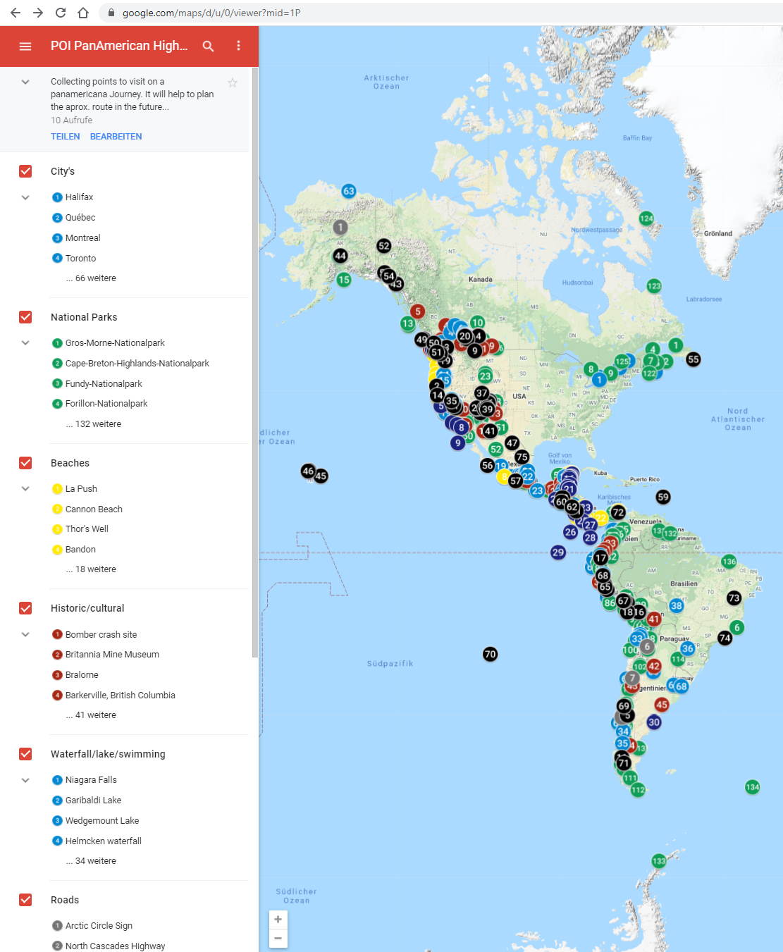
Here you see a POI collection, below a mixed map with POI Collection and a planned route.

I did wrote a lot about this topic. Did test a lot of tools.
What is helpful, depends a lot on the tools you will use later for navigation itself.
Above are Screenshots out of my Google`s My Maps. It is a good allrounder in my eyes - which allows collaboration with others. Allows to share your route and POI to others. And it allows too export and import the POI and Route to your Navigation Device.
If your Navigation Computer cant import KML or GPX Files you may find this way less useful..
I mostly enjoy travelling without a given route, but I love to have a set of Waypoints, to see what is nearby.
But you asked too for a way to find dirt-tracks and handle them. Give the App wikiloc a try. It is just for that - to find driveable dirt kategorized by vehicle category.
Surfy
|
4 Jun 2021
|
|
Registered Users
New on the HUBB
|
|
Join Date: Jun 2021
Posts: 1
|
|
|
There are good videos on a YT (including mine) about Google Maps and route planning. To me greatest value of using the GM is that it's ubiquitous. I mean all over social media there are references to GM and POIs in it. I have collected many places in my GM when somebody is posting on Facebook and recommend a place. Only a couple of clicks I can save the POI in my GM collection for later use. No other mapping software can do this for me.
Also, the GM works in all devices (phones, tablets, laptops, computers) so I can reach my collection of POIs and route planning everywhere.
But I am not totally satisfied with GM and occasionally I use the Garmin BaseCamp and Furkot for my planning purposes. All these have some good in them, but also lacking something.
|
|
Currently Active Users Viewing This Thread: 1 (0 Registered Users and/or Members and 1 guests)
|
|
|
 Posting Rules
|
You may not post new threads
You may not post replies
You may not post attachments
You may not edit your posts
HTML code is Off
|
|
|
|

Check the RAW segments; Grant, your HU host is on every month!
Episodes below to listen to while you, err, pretend to do something or other...

2020 Edition of Chris Scott's Adventure Motorcycling Handbook.
"Ultimate global guide for red-blooded bikers planning overseas exploration. Covers choice & preparation of best bike, shipping overseas, baggage design, riding techniques, travel health, visas, documentation, safety and useful addresses." Recommended. (Grant)

Led by special operations veterans, Stanford Medicine affiliated physicians, paramedics and other travel experts, Ripcord is perfect for adventure seekers, climbers, skiers, sports enthusiasts, hunters, international travelers, humanitarian efforts, expeditions and more.
Ripcord Rescue Travel Insurance™ combines into a single integrated program the best evacuation and rescue with the premier travel insurance coverages designed for adventurers and travel is covered on motorcycles of all sizes.
(ONLY US RESIDENTS and currently has a limit of 60 days.)
Ripcord Evacuation Insurance is available for ALL nationalities.
What others say about HU...
"This site is the BIBLE for international bike travelers." Greg, Australia
"Thank you! The web site, The travels, The insight, The inspiration, Everything, just thanks." Colin, UK
"My friend and I are planning a trip from Singapore to England... We found (the HU) site invaluable as an aid to planning and have based a lot of our purchases (bikes, riding gear, etc.) on what we have learned from this site." Phil, Australia
"I for one always had an adventurous spirit, but you and Susan lit the fire for my trip and I'll be forever grateful for what you two do to inspire others to just do it." Brent, USA
"Your website is a mecca of valuable information and the (video) series is informative, entertaining, and inspiring!" Jennifer, Canada
"Your worldwide organisation and events are the Go To places to for all serious touring and aspiring touring bikers." Trevor, South Africa
"This is the answer to all my questions." Haydn, Australia
"Keep going the excellent work you are doing for Horizons Unlimited - I love it!" Thomas, Germany
Lots more comments here!

Every book a diary
Every chapter a day
Every day a journey
Refreshingly honest and compelling tales: the hights and lows of a life on the road. Solo, unsupported, budget journeys of discovery.
Authentic, engaging and evocative travel memoirs, overland, around the world and through life.
All 8 books available from the author or as eBooks and audio books
Back Road Map Books and Backroad GPS Maps for all of Canada - a must have!
New to Horizons Unlimited?
New to motorcycle travelling? New to the HU site? Confused? Too many options? It's really very simple - just 4 easy steps!
Horizons Unlimited was founded in 1997 by Grant and Susan Johnson following their journey around the world on a BMW R80G/S.
 Read more about Grant & Susan's story
Membership - help keep us going!
Horizons Unlimited is not a big multi-national company, just two people who love motorcycle travel and have grown what started as a hobby in 1997 into a full time job (usually 8-10 hours per day and 7 days a week) and a labour of love. To keep it going and a roof over our heads, we run events all over the world with the help of volunteers; we sell inspirational and informative DVDs; we have a few selected advertisers; and we make a small amount from memberships.
You don't have to be a Member to come to an HU meeting, access the website, or ask questions on the HUBB. What you get for your membership contribution is our sincere gratitude, good karma and knowing that you're helping to keep the motorcycle travel dream alive. Contributing Members and Gold Members do get additional features on the HUBB. Here's a list of all the Member benefits on the HUBB.
|
|
|


 Hybrid Mode


