 8Likes 8Likes
 |
|

16 Mar 2016
|
|
Registered Users
Veteran HUBBer
|
|
Join Date: Aug 2005
Location: Calgary AB
Posts: 1,028
|
|
Quote:
Originally Posted by Redboots

No such problems with the Montana in an AMPS cradle. Used in the car, road bike and dirt bike.
|
I don't understand what the cradle mounting system's impact is in the secure connection of a USB port. Sure, some connections work. Others don't. This inconsistency proves the fact is not designed for it. I even had burnmoto ports fail in Baja. Had to tape it to ensure the flat contact points connected. It only did to a point off course. Pin connector are used in these environment for this reason. The garmin 4 pin connector was great. The 2 pin is too small and the USB not up to the task. Off course it depends on the amount of abuse.
Sent from my SM-G920W8 using Tapatalk
|
16 Mar 2016
|
|
Registered Users
Veteran HUBBer
|
|
Join Date: Aug 2005
Location: Calgary AB
Posts: 1,028
|
|
Quote:
Originally Posted by Arma
I spent a long time using smartphones for navigation and moved on to a Garmin 590LM on my current bike.
Ultimately it was worth the expense, it's a better solution. The phones tended to overheat and at the time few were waterproof. The Xperia I have now would probably be better though and can be charged with the magnetic port, staying waterproof even when charging.
What remains an issue is screen clarity in bright sunlight and control in gloves. No tablet or phone yet invented is very easy to see in direct sunlight, which is a massive pain in the ass on a bike. I never found a good solution for making a normal touchscreen work with thick gloves.
The Garmin I have bypasses all of those problems, it plays music, can stream it from my phone, it accepts OSM maps gladly when I leave Europe. It's just a better all round package. A luxury item, no doubt, my GF won't be forking out on one, she's happy to use her own Xperia, but I'm glad I got mine - right tool for the job.
|
Which apps did you use and didn't you use a case?
I find all screens troublesome in direct sun. But that's easily dealt with in use though.
Sent from my SM-G920W8 using Tapatalk
|
16 Mar 2016
|
 |
Registered Users
Veteran HUBBer
|
|
Join Date: Jan 2016
Location: Lake Constance, Germany
Posts: 149
|
|
|
I used a RAM X-Mount when it was dry and popped it in the tank bag when raining.
Used Google maps and Sygic.
__________________
[ Tim | History - NW Italy/French Rivera, Swiss Alps, Morocco | 2016 - Greece > Albania > Macedonia > Kosovo > Montenegro > Bosnia > Slovenia > Austria ]
|
16 Mar 2016
|
|
Registered Users
Veteran HUBBer
|
|
Join Date: Aug 2005
Location: Calgary AB
Posts: 1,028
|
|
|
Interesting, those magnetic plugs. How strong is the magnet? Between looking at those mounts. As you said. It needs a waterproof phone. But USB ports would be direct to the phone which doesn't work for me. The magnetic port would suit Sony to these mounts well if it's strong enough.
The other thing with this mount is that there is no isolation from vibration.
I'm not sure on overheating. Didn't have that at 30C in sunny Baja in a black case riding first and second gear single and double trail. I covered it when standing still though. Never felt hot.
Sent from my SM-G920W8 using Tapatalk
Last edited by tmotten; 16 Mar 2016 at 17:08.
|
16 Mar 2016
|
|
Registered Users
Veteran HUBBer
|
|
Join Date: Aug 2001
Location: Oslo, Norway
Posts: 521
|
|
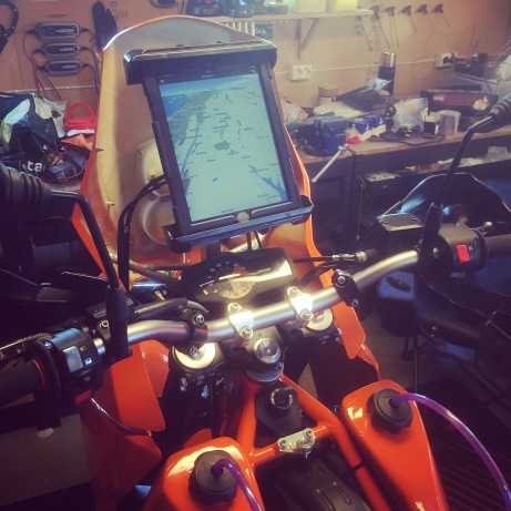
I just bought some ram stuff and put my full size iPad straight into the cockpit of my KTM. It's waterproofed and whatnot. Have an app with read-out of everything from altitude to speed, and there's also a GPS map thingy. When bored I can switch to telly. Heck, there's even an app for roadbooks! Haven't tried the set-up in really heavy terrain when doing the shake-down test, but I will soon.
|
17 Mar 2016
|
|
Gold Member
Veteran HUBBer
|
|
Join Date: Jan 2002
Location: Toronto, Canada
Posts: 2,134
|
|
Quote:
Originally Posted by Threewheelbonnie
I memorize or make a rough list each night and bimble along enjoying the scenery or music...if faced with a city centre, turn on the GPS and listen to advice via headphones.
|
Hi Andy:
That will work well if the rider has some familiarity with the country in which they are riding. For example, I live in Canada, and if I was to ride 4,000 miles across Canada, from coast to coast, I would probably do exactly what you suggest and only turn on my GPS (a Garmin 590) when riding through the center of large cities.
But, when I am riding in a foreign country (e.g. the UK) where I have no familiarity at all with the lay of the land, and even less familiarity with the local language, traffic protocols, signs, where the speed cameras are, and stuff like that, I find that having the GPS on all the time takes a lot of the uncertainty and stress out of navigation, and actually lets me spend more time "enjoying the scenery" than I would have without GPS guidance.
I do agree that the 'recalculating' prompts and voice guidance can sometime be irritating, but they can be turned off (via configuration options within the GPS navigator) as desired. The 'recalculating' voice prompt can be very useful at times... if I hear that the GPS is 'recalculating' a route when I don't expect it to do so, that is a fairly strong hint that I missed a turn somewhere and ought to take a second, more critical look at where I am going, and where the GPS is suggesting I should go.
Michael
|
17 Mar 2016
|
|
Registered Users
Veteran HUBBer
|
|
Join Date: Aug 2005
Location: Calgary AB
Posts: 1,028
|
|
|
It's the software that is responsible for all that. Doesn't matter if it's on a dedicated GPS or not.
Sent from my SM-G920W8 using Tapatalk
|
17 Mar 2016
|
|
Registered Users
Veteran HUBBer
|
|
Join Date: Mar 2007
Location: UK
Posts: 4,343
|
|
Quote:
Originally Posted by indu
I just bought some ram stuff and put my full size iPad straight into the cockpit of my KTM. It's waterproofed and whatnot. Have an app with read-out of everything from altitude to speed, and there's also a GPS map thingy. When bored I can switch to telly. Heck, there's even an app for roadbooks! Haven't tried the set-up in really heavy terrain when doing the shake-down test, but I will soon.
|
Do you pop it into your pocket when the bike is parked somewhere in public?
(it looks pretty vulnerable).
__________________
Dave
|
17 Mar 2016
|
|
Registered Users
Veteran HUBBer
|
|
Join Date: Aug 2001
Location: Oslo, Norway
Posts: 521
|
|
|
I just bring it along when leaving the bike. Not exactly pocket friendly, but it works.
|
13 Jul 2016
|
|
Registered Users
New on the HUBB
|
|
Join Date: Jul 2016
Location: NL
Posts: 12
|
|
|
Start with a normal GPS, I would recommend a motor-oriented GPS: rugged, waterproof, for normal naviation (my LM390 has hit stone-pavement with 80km/h, still working, hehehe).
I dislike the small screen, I dislike the lack of "overview" in general and the l dislike the slow-slow-slow repsonse to finger-commands.
So.. for map-reading, I mostly carry a 7Inch Tablet (I lost my first google-nexus on the Transfagarasan in 2014... Stupid). The tablets tend to be slow as well, but at least they offer a better overview for map-reading (OSM, maps.me, and maps.google.com if on-the-net).
Screen-size not ideal for map-reading yet, but Larger then 7inch is hard to stow away in the tank-case.
In addition to that, I have now dedicated an old-phone, a GS3, to "tracking": it runs ramblr and myadventure.bike to record my whereabouts and allows me to easily record a map+logbook (separate thread). I also use that old phone as additional camera and for OSM maps.me reading (but the screen is too small for that, hence the tablet!). Last but not least, that old phone, with cheapo simcard is my emergency-backup in case the main phone gets lost or damaged.
For true-map-reading, I also still carry paper maps, but less and less.
For planning, I tend to do my rough layout using paper and laptop and then program a few via-points into the Garmin. Plus some pen-on-paper-notes (city-names, road nrs) under the plastic of the tank-case.
__________________
Work to Live. Live to Ride. Ride to Work.
|
14 Jul 2016
|
|
Registered Users
Veteran HUBBer
|
|
Join Date: Aug 2005
Location: Calgary AB
Posts: 1,028
|
|
|
Wow. That's quite a bit of redundancy. Some would say the Garmin is somewhat redundant.
|
14 Jul 2016
|
|
Registered Users
New on the HUBB
|
|
Join Date: Jul 2016
Location: NL
Posts: 12
|
|
Quote:
Originally Posted by tmotten
Wow. That's quite a bit of redundancy. Some would say the Garmin is somewhat redundant.
|
Grinning right at you...
The Garmin is the only device I will use while actually Riding.
it is water-resistant (hell it survived an 80km/h drop on brick/stone road), and it is the only device I use to navigate streets/roads.
All the other devices are either for
map-reading (tablet) or
track-recording and route-logbook (old phone with myadventure.bike + ramblr).
And then there is my actual "phone" or making calls and doing messaging.
A recorded trip of 4 weeks looks like this:
OUG tour spring 2016
this took me close to zero effort: recording is automatic, any picture on Flicr is auto-inserted into the trip, and text can go in via phone or via web-page. And the web-page is "up" from day one so my friends can follow me, and I can brag and show it to ppl I meet on the road.
Anyone with a computer+internet can find you instantly via google myadventure-dot-bike, then T R I P S -slash- one three seven -enter-.
Like I said: a Great Brag or conversation-starter (you just came down from Helsinki???)
All other systems require me to tweak and figet to put route + picure + notes together..
MyAdv is "instant-ride-report". not perfect yet, but a good help for a lazy person like me.
__________________
Work to Live. Live to Ride. Ride to Work.
|
14 Jul 2016
|
|
Registered Users
Veteran HUBBer
|
|
Join Date: Aug 2005
Location: Calgary AB
Posts: 1,028
|
|
Suggestion: Download Locus and try it out. This gives you the ability to scan in your paper maps and upload it into Locus. That way what you see on the paper is what you see on screen which makes it much easier to relate to it when you ride. I personally don't find turn-by-turn necessary but with a plugin and the right maps Locus can also do that. I use it on an S4
Screenshot of T4A paper maps in Locus
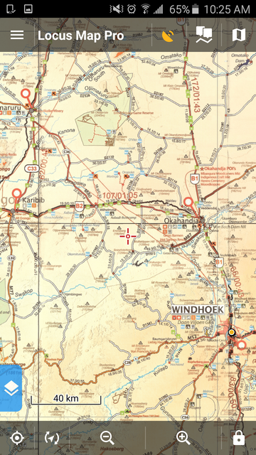
BC with my route drawn in to follow.
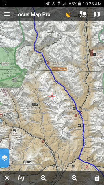
Used it in Baja as well with the Baja Almanac which is really the only decent mapbook of the place.
|
14 Jul 2016
|
|
Registered Users
New on the HUBB
|
|
Join Date: Jul 2016
Location: NL
Posts: 12
|
|
|
Locus: I need to look at my notes (am at work). I've had it on one of my phones for a short while.
From memory; locus seemed excellent for route + trip, and it could "Export" the route-data (export-function was how I found it).
But if I remember well, it didnt do the "web-page-display" e.g. the sharing-to-friends was missing (and I like to show-off, hehehe).
Locus: I'll put it on the list to re-visit.
Questions I generally have when evaluating an app (checklist is at home):
- Does it easily record month-long trips (and display them) Several apps crash when too-much-data is collected and you have to do day-by-day fidgeting and then "glue" the trip together.. sigh.
- Does it survive phone-battery-dead and continue tracking on switch-on? (most apps will have to start a new trip..)
- Does it easily integrate text-notes and pictures ? my-adv simply picks up my public flckr pictures, hence anything I put on flickr goes into the ride-report with zero effort, no cables, no drag-n-drop-hassle. Some others will indiscriminately harvest _all_ pictures from the phone.. ai.
- Does it allow me privacy? Can I erase pieces of a trip (Myadv cannot yet dot this - I'm pushing for that option!).
__________________
Work to Live. Live to Ride. Ride to Work.
|
14 Jul 2016
|
|
Registered Users
Veteran HUBBer
|
|
Join Date: Aug 2005
Location: Calgary AB
Posts: 1,028
|
|
Not sure on most those. I'm not that demanding, but you should try and let me know. 
It does restart the track recording. My phone ran out of battery because I kept it plugged in and on with the engine on. It started right back up where it left off. Not sure on the max number of points either. Try it. It may be published somewhere as well. I do daily route recordings so I can back it up. But in reality I don't really need to record unless I change course from the plan I guess.
|
|
Currently Active Users Viewing This Thread: 1 (0 Registered Users and/or Members and 1 guests)
|
|
|
 Posting Rules
|
You may not post new threads
You may not post replies
You may not post attachments
You may not edit your posts
HTML code is Off
|
|
|
|

Check the RAW segments; Grant, your HU host is on every month!
Episodes below to listen to while you, err, pretend to do something or other...

2020 Edition of Chris Scott's Adventure Motorcycling Handbook.
"Ultimate global guide for red-blooded bikers planning overseas exploration. Covers choice & preparation of best bike, shipping overseas, baggage design, riding techniques, travel health, visas, documentation, safety and useful addresses." Recommended. (Grant)

Led by special operations veterans, Stanford Medicine affiliated physicians, paramedics and other travel experts, Ripcord is perfect for adventure seekers, climbers, skiers, sports enthusiasts, hunters, international travelers, humanitarian efforts, expeditions and more.
Ripcord Rescue Travel Insurance™ combines into a single integrated program the best evacuation and rescue with the premier travel insurance coverages designed for adventurers and travel is covered on motorcycles of all sizes.
(ONLY US RESIDENTS and currently has a limit of 60 days.)
Ripcord Evacuation Insurance is available for ALL nationalities.
What others say about HU...
"This site is the BIBLE for international bike travelers." Greg, Australia
"Thank you! The web site, The travels, The insight, The inspiration, Everything, just thanks." Colin, UK
"My friend and I are planning a trip from Singapore to England... We found (the HU) site invaluable as an aid to planning and have based a lot of our purchases (bikes, riding gear, etc.) on what we have learned from this site." Phil, Australia
"I for one always had an adventurous spirit, but you and Susan lit the fire for my trip and I'll be forever grateful for what you two do to inspire others to just do it." Brent, USA
"Your website is a mecca of valuable information and the (video) series is informative, entertaining, and inspiring!" Jennifer, Canada
"Your worldwide organisation and events are the Go To places to for all serious touring and aspiring touring bikers." Trevor, South Africa
"This is the answer to all my questions." Haydn, Australia
"Keep going the excellent work you are doing for Horizons Unlimited - I love it!" Thomas, Germany
Lots more comments here!

Every book a diary
Every chapter a day
Every day a journey
Refreshingly honest and compelling tales: the hights and lows of a life on the road. Solo, unsupported, budget journeys of discovery.
Authentic, engaging and evocative travel memoirs, overland, around the world and through life.
All 8 books available from the author or as eBooks and audio books
Back Road Map Books and Backroad GPS Maps for all of Canada - a must have!
New to Horizons Unlimited?
New to motorcycle travelling? New to the HU site? Confused? Too many options? It's really very simple - just 4 easy steps!
Horizons Unlimited was founded in 1997 by Grant and Susan Johnson following their journey around the world on a BMW R80G/S.
 Read more about Grant & Susan's story
Membership - help keep us going!
Horizons Unlimited is not a big multi-national company, just two people who love motorcycle travel and have grown what started as a hobby in 1997 into a full time job (usually 8-10 hours per day and 7 days a week) and a labour of love. To keep it going and a roof over our heads, we run events all over the world with the help of volunteers; we sell inspirational and informative DVDs; we have a few selected advertisers; and we make a small amount from memberships.
You don't have to be a Member to come to an HU meeting, access the website, or ask questions on the HUBB. What you get for your membership contribution is our sincere gratitude, good karma and knowing that you're helping to keep the motorcycle travel dream alive. Contributing Members and Gold Members do get additional features on the HUBB. Here's a list of all the Member benefits on the HUBB.
|
|
|


 Linear Mode


