 7Likes 7Likes
-
 2
Post By sushi2831
2
Post By sushi2831
-
 2
Post By Scrabblebiker
2
Post By Scrabblebiker
-
1
Post By edwardbgill
-
2
Post By Tomkat
 |

7 Apr 2023
|
|
Registered Users
Veteran HUBBer
|
|
Join Date: Mar 2013
Location: London
Posts: 202
|
|
|
Google Maps - Earth's curvature
I'm sure that this has been covered elsewhere, but if so I'm struggling to find out where.
Does Google Maps account for the Earth's curvature when calculating distances?
I'm aware that they moved the mapping from the Mercator projection in 2016 to the current 'globe' model, so I'm guessing that it now does.
My tacho wasn't working last summer for a longer term, so sadly I don't know how far I travelled on the ground vs. what Google says!
Cheers,
Ed
|
9 Apr 2023
|
|
Registered Users
HUBB regular
|
|
Join Date: May 2022
Location: Verona, Italy
Posts: 35
|
|
|
Hi Ed,
I am a map/mapping enthusiast so I clicked your post. What do you feel could be the problem with the calculations? Why would they be inaccurate? Could you explain this better? Are you concerned about elevation changes affecting the X and Y distances?
J
|
9 Apr 2023
|
|
Registered Users
Veteran HUBBer
|
|
Join Date: Oct 2011
Location: Bern, CH
Posts: 264
|
|
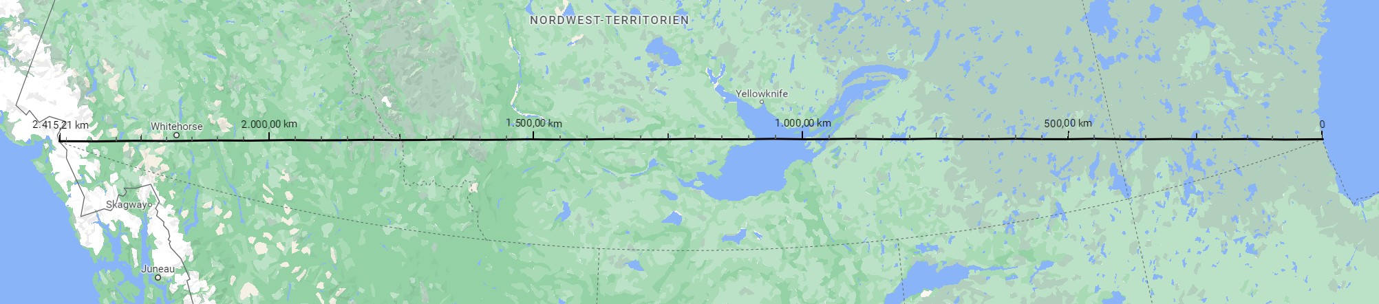
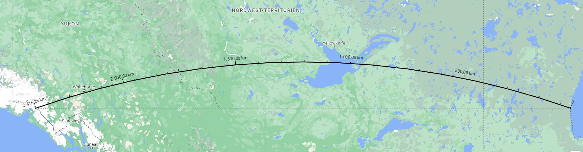
Hello
With and without globemode. (50m gap due to my manual clicking)
When I plan a route on google maps, I have to add up to 1.5 times more km overoll , on a trip.
If it's just 1000km freeway, google maps is good,but still more km needed for gas and food detours.
sushi
Last edited by sushi2831; 9 Apr 2023 at 10:35.
|
9 Apr 2023
|
|
Registered Users
Veteran HUBBer
|
|
Join Date: Mar 2013
Location: London
Posts: 202
|
|
|
Google Maps - Earth's curvature
Quote:
Originally Posted by Il Bandito Lontano

Hi Ed,
I am a map/mapping enthusiast so I clicked your post. What do you feel could be the problem with the calculations? Why would they be inaccurate? Could you explain this better? Are you concerned about elevation changes affecting the X and Y distances?
J
|
Hi J
Great, thanks.
Simple concern is that a distance measured on Google Maps would be longer in real life due to the Maps modelling not taking into account the Earth's curvature.
Ed
Sent from my iPhone using Tapatalk
Last edited by edwardbgill; 9 Apr 2023 at 20:46.
|
9 Apr 2023
|
|
Registered Users
Veteran HUBBer
|
|
Join Date: Mar 2013
Location: London
Posts: 202
|
|
Quote:
Originally Posted by sushi2831
Hello
With and without globemode. (50m gap due to my manual clicking)
When I plan a route on google maps, I have to add up to 1.5 times more km overoll , on a trip.
If it's just 1000km freeway, google maps is good,but still more km needed for gas and food detours.
sushi
|
Thanks Sushi - and I do something similar, though actually go to 2 x the suggested distance for the same reason, with the 'non-motorway' option ticked.
|
10 Apr 2023
|
|
Registered Users
Veteran HUBBer
|
|
Join Date: Oct 2014
Location: Brunei
Posts: 987
|
|
Quote:
Originally Posted by edwardbgill
I'm sure that this has been covered elsewhere, but if so I'm struggling to find out where.
Does Google Maps account for the Earth's curvature when calculating distances?
I'm aware that they moved the mapping from the Mercator projection in 2016 to the current 'globe' model, so I'm guessing that it now does.
My tacho wasn't working last summer for a longer term, so sadly I don't know how far I travelled on the ground vs. what Google says!
Cheers,
Ed
|
By 'curvature of the Earth' do you mean projection?
I'm no programmer but I would guess that since Google maps has to stitch in swaths of satellite imagery onto its earth model, it would have to use a geode (I assume WGS84) and that point-to-point distances would be caluclated using the geode, not using the projection of the user-selected area of interest.
You could check this (if the software allows) by measuring a distance between two points and seeing if it changes when you zoom right out and Google Maps flicks from 2D projection to 3D model.
If you are worried that Google Maps measure the straight line distance between two points in 3D space, i.e. it would connect London and Auckland by burrowing straight through the centre of the Earth, this would be very easy to check (and I am sure it does not).
Quote:
Originally Posted by Il Bandito Lontano
Hi Ed,
I am a map/mapping enthusiast so I clicked your post. What do you feel could be the problem with the calculations? Why would they be inaccurate? Could you explain this better? Are you concerned about elevation changes affecting the X and Y distances?
J
|
The problem is one of projection, mapping a section of the oblate spheroid we live on onto a flat screen/map.
One a paper map, the common Mercator projection greatly exaggerates area in high latitudes because it 'straightens' the curvature of the Earth.
EO
__________________
EurasiaOverland a memoir of one quarter of a million kilometres by road through all of the Former USSR, Western and Southern Asia.
|
10 Apr 2023
|
|
Super Moderator
Veteran HUBBer
|
|
Join Date: Jul 2007
Location: Bellingham, WA, USA
Posts: 4,036
|
|
|
Surely I’m missing the point here…..?
Seems to me no one is really that interested in direct, point-to-point distance on the earth’s surface except airline pilots. Look at the illustration given above: there are few roads in the Yukon and NW Territories, so what use is a straight line from one place to another, with or without latitude-induced errors of any sort? What you want is the driving distance, which is a whole different thing.
I don’t calculate distances using Google maps, so please pardon my ignorance in advance. As stated above, checking the distance from Auckland (say) to London will confirm that distances in any mapping application are given on the surface, not taking a direct line through the center of the earth. And if you want to know how long a road journey is, just Google up “Driving distance from X to Y,” and you’ll have your answer.
What you won’t get is the driving distance from somewhere in the Fairweather Range (no roads there, although a couple of major rivers and some notable glaciers) and Hudson’s Bay (no roads there either, but one intermittently-operational railway line if you’re interested).
[/cluelessness about what’s being asked here]
|
10 Apr 2023
|
|
Registered Users
Veteran HUBBer
|
|
Join Date: Mar 2013
Location: London
Posts: 202
|
|
Quote:
Originally Posted by markharf
Surely I’m missing the point here…..?
Seems to me no one is really that interested in direct, point-to-point distance on the earth’s surface except airline pilots. Look at the illustration given above: there are few roads in the Yukon and NW Territories, so what use is a straight line from one place to another, with or without latitude-induced errors of any sort? What you want is the driving distance, which is a whole different thing.
I don’t calculate distances using Google maps, so please pardon my ignorance in advance. As stated above, checking the distance from Auckland (say) to London will confirm that distances in any mapping application are given on the surface, not taking a direct line through the center of the earth. And if you want to know how long a road journey is, just Google up “Driving distance from X to Y,” and you’ll have your answer.
What you won’t get is the driving distance from somewhere in the Fairweather Range (no roads there, although a couple of major rivers and some notable glaciers) and Hudson’s Bay (no roads there either, but one intermittently-operational railway line if you’re interested).
[/cluelessness about what’s being asked here]
|
I think we're overcomplicating the question here.
Let me put it in more simple terms; aside from the pros/cons of various ways of planning a route, if I search for driving directions for London to Cape Town in Google Maps (simply for the purpose to get an idea of the rough distance involved) will the distance it gives for a journey that long, be accurate?
Thanks
Ed
|
10 Apr 2023
|
|
Registered Users
Veteran HUBBer
|
|
Join Date: May 2018
Location: Iceland
Posts: 103
|
|
Quote:
Originally Posted by edwardbgill
if I search for driving directions for London to Cape Town in Google Maps (simply for the purpose to get an idea of the rough distance involved) will the distance it gives for a journey that long, be accurate?
Thanks
Ed
|
I like this topic. I think I know what you are looking for but it is funny to read you want a ¨accurate¨ distance for a ¨rough idea¨
Don´t get me wrong, I am merely joking here 
You an Sushi seem to take the whole distance from google maps and multiply that with some number. The outcome must be a very rough idea I think. I don´t do that. I like to take shorter sections and drag the route, given by google maps, to the roads I plan to drive. Then the outcome is fairly accurate.
For me, that way of planning is part of the fun, I like playing with it and maybe I have nothing better to do with my life
In a perfect world the outcome would be 100% accurate, but what is accurate?
I drive a 4x4 but there is quite a difference in distance what my car shows and what my gps via Orux maps shows. Part of the problem are probably the bigger tires under my car.
I think the asnwer to you question is NO. It won´t be accurate.
Not taking into account whether there are any mapping issues, there is something else what bothers me.
Google maps shows the distance for parts of the route we are traveling by ferry.
For example: it shows London - Cape Town to be 8185 miles via France. But its shows 8144 miles when taking the ferry from Plymouth to Santander. This is only a small difference although the driving distance that Mark(harf) is talking about is considerably shorter.
|
10 Apr 2023
|
|
Registered Users
Veteran HUBBer
|
|
Join Date: Mar 2013
Location: London
Posts: 202
|
|
Quote:
Originally Posted by Rognv
I like this topic. I think I know what you are looking for but it is funny to read you want a ¨accurate¨ distance for a ¨rough idea¨
Don´t get me wrong, I am merely joking here
You an Sushi seem to take the whole distance from google maps and multiply that with some number. The outcome must be a very rough idea I think. I don´t do that. I like to take shorter sections and drag the route, given by google maps, to the roads I plan to drive. Then the outcome is fairly accurate.
For me, that way of planning is part of the fun, I like playing with it and maybe I have nothing better to do with my life
In a perfect world the outcome would be 100% accurate, but what is accurate?
I drive a 4x4 but there is quite a difference in distance what my car shows and what my gps via Orux maps shows. Part of the problem are probably the bigger tires under my car.
I think the asnwer to you question is NO. It won´t be accurate.
Not taking into account whether there are any mapping issues, there is something else what bothers me.
Google maps shows the distance for parts of the route we are traveling by ferry.
For example: it shows London - Cape Town to be 8185 miles via France. But its shows 8144 miles when taking the ferry from Plymouth to Santander. This is only a small difference although the driving distance that Mark(harf) is talking about is considerably shorter. |
Lol, thanks Rognv.
Yes, you're sort of right - before I start to plan, I typically have a rough idea of budget/time I can spend away before a trip and know that I'll typically average around 150km-175km a day. So I use Google Maps to get a rough idea of what kind of trip might be possible in that time.
Once I've decided on where I'm going, I'll establish a rough direction of travel and then work from area to area when I'm in-country, typically planning the detail of where I actually go for two - three days ahead, using (until recently) Outdooractive and (now) Osmand and Open Street Maps.
So, I don't actually use Google Maps to plan a route - just to understand what in theory might/might not be possible given my constraints for that particular trip. Hope that makes sense.
I see what you are saying about the distance from your wheels, by the way - the reason why I asked this question was that when riding London to Sydney, my bike odometer clocked 60,000km by the end of the trip, which seemed a lot higher distance than when later on tried to copy my trip onto Google Maps.
Cheers,
Ed
|
10 Apr 2023
|
|
Registered Users
Veteran HUBBer
|
|
Join Date: Sep 2006
Location: California
Posts: 881
|
|
|
I think you are over-complicating things here... as an overview over a long distance (which has limited real-world practicality anyway), then Google maps going to give you an approximate distance value as a straight line...
However as soon as you 'calacutate' directions, it's going to snap to the [what it considers] is the most efficient next work of roads (and any ferry routes etc) which have been far more accurately catalogued with regard to actual distance over the ground.
The world is a BIG place - you can't expect to navigate around it all in one hit. Practically speaking you're going to break it down into country, weekly, daily portions anyway... just keep a tally of how far you've actually travelled (from your odometer or GPS track-log) if that sort of thing really matters to you?
Jx
|
10 Apr 2023
|
|
Registered Users
Veteran HUBBer
|
|
Join Date: Jun 2007
Location: Cowichan Bay, Vancouver Island, BC, Canada
Posts: 342
|
|
|
In my experience short distances tend to be quite accurate on Google Maps. For very long distances it should be reasonably accurate as long as you follow the exact routing Google Maps gives you. Unfortunately in real life for expedition length trips that simply isn't realistic. Google Maps has led me to abandoned dirt roads cut off by a 10 metre deep ravine and led me to sketchy dirt tracks since those would have been shorter than the maintained roads leading around it. Google Maps often doesn't know the condition of the roads it leads you to or whether they're even remotely usable. It just seems to care about what the shortest distance is.
During the forest fires in the Yukon Google Maps gave me a detour around the closed highway between Dawson City and Whitehorse. It involved using a road which for all intents and purposes no longer exists. The point being that the roads you're actually taking on a long trip are very unlikely to be 100% the ones suggested by Google Maps in most cases.
For a case in point try Port Renfrew, BC to Bamfield, BC. It shows a route of 136Km via the aforementioned ravine or the actually usable road as an alternative at 163Km. On a 60,000 km trip you will likely have dozens of these situations to compound the discrepancies of Google Maps.
|
10 Apr 2023
|
|
Registered Users
Veteran HUBBer
|
|
Join Date: Mar 2013
Location: London
Posts: 202
|
|
Quote:
Originally Posted by JMo (& piglet)
I think you are over-complicating things here... as an overview over a long distance (which has limited real-world practicality anyway), then Google maps going to give you an approximate distance value as a straight line...
However as soon as you 'calacutate' directions, it's going to snap to the [what it considers] is the most efficient next work of roads (and any ferry routes etc) which have been far more accurately catalogued with regard to actual distance over the ground.
The world is a BIG place - you can't expect to navigate around it all in one hit. Practically speaking you're going to break it down into country, weekly, daily portions anyway... just keep a tally of how far you've actually travelled (from your odometer or GPS track-log) if that sort of thing really matters to you?
Jx
|
Potentially yes re: over-complicating things a little.
But as per my earlier post, I'm not actually looking to use GoogleMaps to plan in detail and take a very different approach to this (as set out), or even keep to keep a tally of the distance. It was more a general question/point!
Cheers,
Ed
|
11 Apr 2023
|
|
Registered Users
Veteran HUBBer
|
|
Join Date: Oct 2016
Location: Devon, UK
Posts: 880
|
|
|
AFAIK Google Maps plans a road route between points A and B, so curvature is irrelevant. You will not be travelling "as the crow flies". Rough estimates of distance are all very well for planning, but they will necessarily be approximate, nothing more.
But to the OP, if you zoom right out and then move from one location to another, you can see the shapes of the land masses change, so yes, Google does account for curvature.
|
|
Currently Active Users Viewing This Thread: 4 (0 Registered Users and/or Members and 4 guests)
|
|
|
 Posting Rules
|
You may not post new threads
You may not post replies
You may not post attachments
You may not edit your posts
HTML code is Off
|
|
|
|

Check the RAW segments; Grant, your HU host is on every month!
Episodes below to listen to while you, err, pretend to do something or other...

2020 Edition of Chris Scott's Adventure Motorcycling Handbook.
"Ultimate global guide for red-blooded bikers planning overseas exploration. Covers choice & preparation of best bike, shipping overseas, baggage design, riding techniques, travel health, visas, documentation, safety and useful addresses." Recommended. (Grant)

Led by special operations veterans, Stanford Medicine affiliated physicians, paramedics and other travel experts, Ripcord is perfect for adventure seekers, climbers, skiers, sports enthusiasts, hunters, international travelers, humanitarian efforts, expeditions and more.
Ripcord Rescue Travel Insurance™ combines into a single integrated program the best evacuation and rescue with the premier travel insurance coverages designed for adventurers and travel is covered on motorcycles of all sizes.
(ONLY US RESIDENTS and currently has a limit of 60 days.)
Ripcord Evacuation Insurance is available for ALL nationalities.
What others say about HU...
"This site is the BIBLE for international bike travelers." Greg, Australia
"Thank you! The web site, The travels, The insight, The inspiration, Everything, just thanks." Colin, UK
"My friend and I are planning a trip from Singapore to England... We found (the HU) site invaluable as an aid to planning and have based a lot of our purchases (bikes, riding gear, etc.) on what we have learned from this site." Phil, Australia
"I for one always had an adventurous spirit, but you and Susan lit the fire for my trip and I'll be forever grateful for what you two do to inspire others to just do it." Brent, USA
"Your website is a mecca of valuable information and the (video) series is informative, entertaining, and inspiring!" Jennifer, Canada
"Your worldwide organisation and events are the Go To places to for all serious touring and aspiring touring bikers." Trevor, South Africa
"This is the answer to all my questions." Haydn, Australia
"Keep going the excellent work you are doing for Horizons Unlimited - I love it!" Thomas, Germany
Lots more comments here!

Every book a diary
Every chapter a day
Every day a journey
Refreshingly honest and compelling tales: the hights and lows of a life on the road. Solo, unsupported, budget journeys of discovery.
Authentic, engaging and evocative travel memoirs, overland, around the world and through life.
All 8 books available from the author or as eBooks and audio books
Back Road Map Books and Backroad GPS Maps for all of Canada - a must have!
New to Horizons Unlimited?
New to motorcycle travelling? New to the HU site? Confused? Too many options? It's really very simple - just 4 easy steps!
Horizons Unlimited was founded in 1997 by Grant and Susan Johnson following their journey around the world on a BMW R80G/S.
 Read more about Grant & Susan's story
Membership - help keep us going!
Horizons Unlimited is not a big multi-national company, just two people who love motorcycle travel and have grown what started as a hobby in 1997 into a full time job (usually 8-10 hours per day and 7 days a week) and a labour of love. To keep it going and a roof over our heads, we run events all over the world with the help of volunteers; we sell inspirational and informative DVDs; we have a few selected advertisers; and we make a small amount from memberships.
You don't have to be a Member to come to an HU meeting, access the website, or ask questions on the HUBB. What you get for your membership contribution is our sincere gratitude, good karma and knowing that you're helping to keep the motorcycle travel dream alive. Contributing Members and Gold Members do get additional features on the HUBB. Here's a list of all the Member benefits on the HUBB.
|
|
|


 Linear Mode


