 14Likes 14Likes
 |
|

18 Jun 2016
|
|
Registered Users
Veteran HUBBer
|
|
Join Date: Mar 2006
Location: Switzerland
Posts: 232
|
|
|
Mongolia map
Hi all,
we've just releasing a new guidebook about Mongolia, and although it is in French only, we're giving away a full-scale map of the country with the majors roads and landmarks.
In our experience there isn't a good map about Mongolia, all are pretty much wrong half of the place. This one may not be much better but it's free (as in free  ). So you can download it, print it, etc.. but do not modify it and please do not upload it to other websites. It's based mostly on our own experience, but also other's and OpenStreetMap as well.
Yes, you can find the same data in OpenStreetMap, but it's not easy to print and doesn't give a good sense of hierarchy. Indeed, the digital maps made out of it (think maps.me, OruxMaps, etc.. ) are difficult to use because you have to zoom in a lot to see some otherwise important tracks. Why ? because any unsurfaced road could be tagged as a "primary road", a "secondary road", a "track" or a random "road", depending on the contributor's mood, but the result is that they show at very different zoom levels. The scheme is well tuned for western countries, but doesn't quite work in Mongolia.
Note: there are thousands of tracks in Mongolia that could qualify as roads, or not, depending on how you look at it. So all maps are very subjective, including this one. But I believe it can be very useful, particularly in the early stages of planning, to get the full picture. The landmarks correspond to the selection of itineraries described in our book, so they're far from exhaustive.
Of course, all feedback and corrections are welcome, I'd like to keep it current and improve on it, as a lot of road building is happening right now in Mongolia.
Enjoy !
Laurent + Cécile
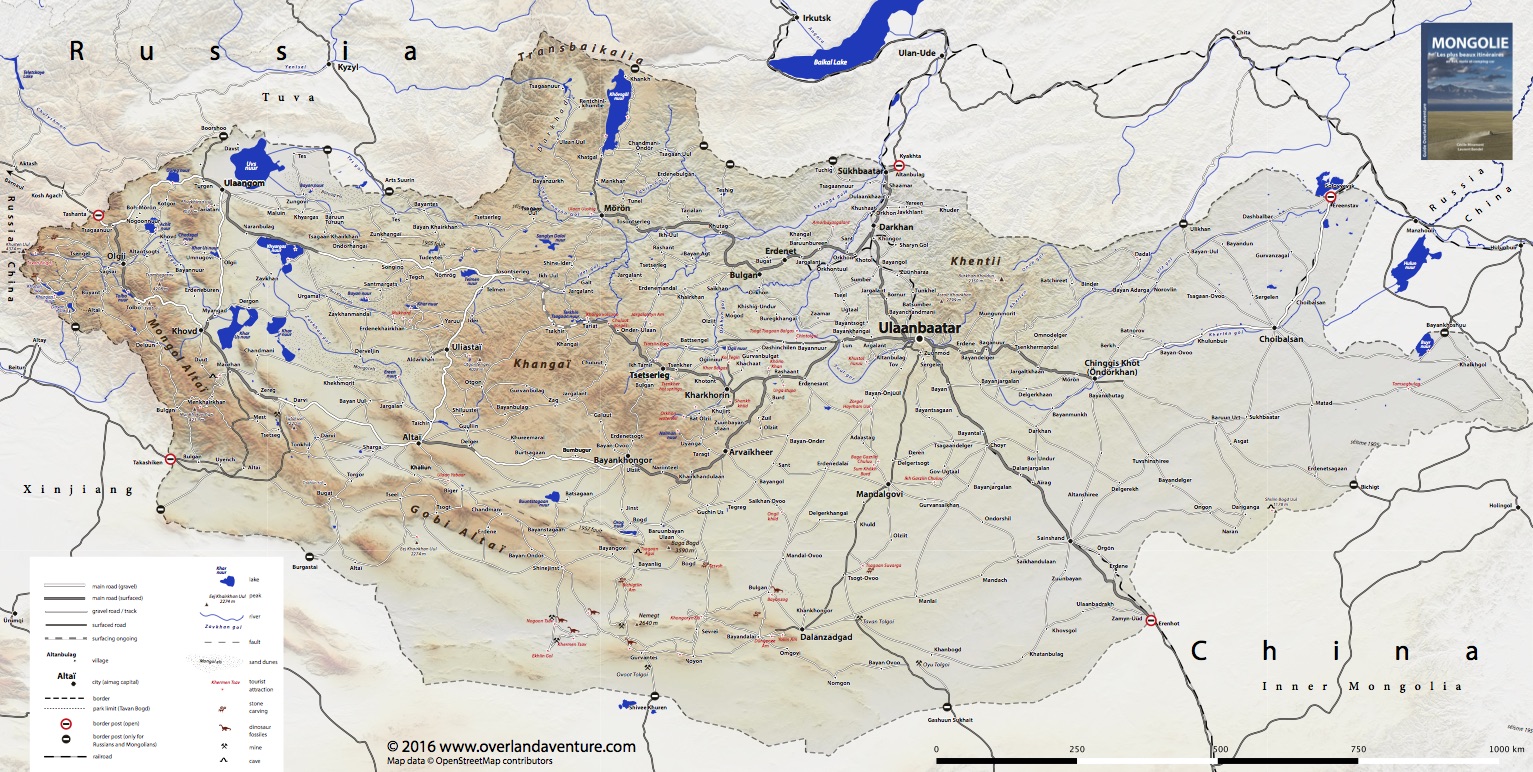
Sorry I can't upload it here as an attachment as it's too big - even with low-res terrain.
The PDF map can be downloaded here: https://www.overlandaventure.com/categorie-produit/maps/
And for those who get along with French, our guidebook can be ordered here: Overland Aventure
Last edited by lbendel; 15 May 2019 at 16:24.
Reason: Updating download links
|
18 Jun 2016
|
|
Registered Users
Veteran HUBBer
|
|
Join Date: Nov 2014
Location: Netherlands
Posts: 157
|
|
|
Last year is was in Mongolia and have marked quite a lot of things. Shops. Bathhouses. General stuff. They are not in osm yet. Interested to have them?
Sent from my GT-I9505 using Tapatalk
|
18 Jun 2016
|
|
Registered Users
Veteran HUBBer
|
|
Join Date: Aug 2012
Location: Australia
Posts: 1,131
|
|
|
lbendel;
You are correct in that maps that are configured for world use (OSM, Garmin, TomTom etc) render for those congested parts of the world .. thus render well in Europe, USA ... but are poor in less well populated/developed parts. It has been noted within the OSM community and people are thinking about it. There are also the 'Tracks for Australia' and 'Tracks for Africa' maps that do a good job of bringing adventure tracks to prominence on the map. My thought are that the rendering should take into account the number of things rendered per unit area and increase it where there is little rendered.
Oh, 'unsurfaced' is 'unpaved'.
Blommetje:
Put them into OSM and everyone then has access to them.
------------------
I would like to make 'Adventure' maps - bringing to prominence World Heritage Areas, National Parks, camp sites, roads and tracks where major highways don't exist ... and fuel stations where there are long distances between them. But there are lots of 'thinks to do'...
|
19 Jun 2016
|
|
Registered Users
Veteran HUBBer
|
|
Join Date: Mar 2006
Location: Switzerland
Posts: 232
|
|
Thanks. I think any more waypoints would clutter the map. Walter (Colebatch) is maintaining a database of useful waypoints (see sticky post), it would fit better there. Or, as mentioned, add it to OSM, but the problem with OSM is, once a feature is added it's often not updated. Maintenance is a big issue in OSM.
Also, as discussed in that thread, there is now fuel in most towns, so it becomes less important to mark them. My mongolian map has fuel icons almost everywhere, and it's not far from the truth. OTOH, if you have wp for bathhouses, that would be a nice addition to Walter's list as they are often unmarked and difficult to find - unlike petrol stations.
Although if you really want to blend in with the locals you shouldn't worry too much about bathhouses 
Laurent
|
20 Jun 2016
|
 |
Registered Users
Veteran HUBBer
|
|
Join Date: Nov 2004
Location: London / Moscow
Posts: 1,913
|
|
Quote:
Originally Posted by Blommetje

Last year is was in Mongolia and have marked quite a lot of things. Shops. Bathhouses. General stuff. They are not in osm yet. Interested to have them?
Sent from my GT-I9505 using Tapatalk
|
Please see Northern Asia Waypoints file .... and send them in. http://www.horizonsunlimited.com/hub...aypoints-50860
|
18 Apr 2017
|
|
Registered Users
Veteran HUBBer
|
|
Join Date: Mar 2006
Location: Switzerland
Posts: 232
|
|
|
V2.0
Well, it's been one year already and many of you have downloaded this map. But my last visit there dates from 2 years back and lots of things have changed in Mongolia in the meantime.
I'd like to keep it up-to-date, with the help of you guys. Many are preparing to visit Mongolia in 2017 and I would like to get recent updates. E.g. I know that they've now surfaced the south road between Altaï and Bayankhongor.
Of course there are thousands of miles of tracks that don't appear on this general map, the idea is to keep only the main roads. But it would be useful to know when a road is being worked on, the surface type, etc..
Ideally, we would find all of this in openstreetmap, but the fact is, it's not very consistent and not updated very often. I've done quite a bit of editing already as I came across errors but it's a long shot.
So if you send it to me, I'll include it in the (always free) printable map and edit the correspnding data in openstreetmap (if not done already). If a new road is being built, I'd need the GPS tracks; if it's being surfaced, the current end of the roadwork; etc.. of course all of this would need to be sharable to the openstreetmap community, so no copyright stuff from Google/Yandex or such (as if Google was of any help in Mongolia..)
I don't think I'll add to the map all the POIs that are being shared, such as hotels and ATMs, that would clutter it too much. Petrol stations are now pretty frequent so I don't think it's so important anymore to mark them. New border posts or restrited area checkpoints are welcome. As are any suggestion ofr improvement, of course.
A v2.0 would come this fall with all the contributions from this summer.
Cheers,
Laurent
|
23 Apr 2017
|
|
Registered Users
New on the HUBB
|
|
Join Date: Mar 2017
Posts: 9
|
|
Quote:
Originally Posted by lbendel
Well, it's been one year already and many of you have downloaded this map. But my last visit there dates from 2 years back and lots of things have changed in Mongolia in the meantime.
I'd like to keep it up-to-date, with the help of you guys. Many are preparing to visit Mongolia in 2017 and I would like to get recent updates. E.g. I know that they've now surfaced the south road between Altaï and Bayankhongor.
Of course there are thousands of miles of tracks that don't appear on this general map, the idea is to keep only the main roads. But it would be useful to know when a road is being worked on, the surface type, etc..
Ideally, we would find all of this in openstreetmap, but the fact is, it's not very consistent and not updated very often. I've done quite a bit of editing already as I came across errors but it's a long shot.
So if you send it to me, I'll include it in the (always free) printable map and edit the correspnding data in openstreetmap (if not done already). If a new road is being built, I'd need the GPS tracks; if it's being surfaced, the current end of the roadwork; etc.. of course all of this would need to be sharable to the openstreetmap community, so no copyright stuff from Google/Yandex or such (as if Google was of any help in Mongolia..)
I don't think I'll add to the map all the POIs that are being shared, such as hotels and ATMs, that would clutter it too much. Petrol stations are now pretty frequent so I don't think it's so important anymore to mark them. New border posts or restrited area checkpoints are welcome. As are any suggestion ofr improvement, of course.
A v2.0 would come this fall with all the contributions from this summer.
Cheers,
Laurent
|
Are you sure about the Altaï-Bayankhongor road? I thought only the first 120 km were paved. At least it was in October 2016. See To Mongolia: The Mongolian Road Network
I am interested because we plan to do the southern road this summer on a small 2WD car (not with the Mongol Rally), so I am a bit insecure about making 300km of gravel/sand/washboard.
Thanks,
Josephine
|
25 Apr 2017
|
|
Registered Users
HUBB regular
|
|
Join Date: Apr 2015
Location: Galicia
Posts: 60
|
|
|
Last year, at July, there were some sections very close to be finished between Altaï-Bayankhongor.
|
10 May 2017
|
|
Registered Users
HUBB regular
|
|
Join Date: Nov 2015
Location: WA Australia
Posts: 27
|
|
|
Passing through this year.
Thanks for the map!  I'm sure it'll come in handy.
We're hoping to cross Mongolia this summer. I don't know how to update the map I've downloaded but I'll make notes on paper and maybe send them to you.
Lee n Veronika
|
10 May 2017
|
|
Registered Users
Veteran HUBBer
|
|
Join Date: Aug 2012
Location: Australia
Posts: 1,131
|
|
Quote:
Originally Posted by LeeCoates
We're hoping to cross Mongolia this summer. I don't know how to update the map I've downloaded but I'll make notes on paper and maybe send them to you.
|
I put my map notes on the map - keeps them all together.
Your changes might made directly into OSM if you join - free and easy.
|
11 May 2017
|
|
Registered Users
Veteran HUBBer
|
|
Join Date: Nov 2004
Location: London / Moscow
Posts: 1,913
|
|
Thousands of 2WD cars do the Southern Route every year.
You will be fine
Quote:
Originally Posted by Pepa
Are you sure about the Altaï-Bayankhongor road? I thought only the first 120 km were paved. At least it was in October 2016. See To Mongolia: The Mongolian Road Network
I am interested because we plan to do the southern road this summer on a small 2WD car (not with the Mongol Rally), so I am a bit insecure about making 300km of gravel/sand/washboard.
Thanks,
Josephine |
|
1 Jan 2019
|
|
Registered Users
Veteran HUBBer
|
|
Join Date: Mar 2006
Location: Switzerland
Posts: 232
|
|
|
Dudes,
an update of this maps is way overdue. I'd like to get some feedback from you if you've been in Mongolia lately. Specifically, what is the progress of the surfacing on the South and Middle road. I guess most of the work is going toward those roads, but any input or correction is welcome too. GPS tracks welcome if it helps.
I'll gather your inputs and put together a V2 of the above, would be great for all of us. And I'll update OSM as well in case it's not up to date with the new info.
Thanks all and I hope many of us will visit Mongolia in 2019 !
Laurent
|
1 Jan 2019
|
|
Registered Users
Veteran HUBBer
|
|
Join Date: Nov 2011
Location: Netherlands
Posts: 377
|
|
Hi Laurant, didnt know that you offered this map, we went through Mongolia last August.
I knew about your book and didnt buy it because my French is mediocre, but I saw it with French travellers and decided to have a peak because your book is one of the few describing the tracks in and sights in Zavkhan / Khar Nuur area, that was great!
One small note there is that the last part of the road up to the center of the Khar Lake, where the sand dunes go into the water, is now blocked by some wooden poles, it is a protection area for a specific type of birds. This place:
https://maps.app.goo.gl/zH4Wj
We were still able to find a random way accross the sand dunes, or you could just stop earlier if you want to camp at the coast line.
Regarding the roads. Olgi to Hovd has a lot of parts with construction work but it is looking promising. Maybe next year most of it is finished, maybe not. But what was finished was really good.
From Ulaanbataar south to Gobi desert is now asphalt up to Bayandali! The rest of the sights in the Gobi are reached by tracks, probably how it has been for years. But rainfall made some cuts in the tracks. You can still pass all of them, just some have more erosion.
__________________
2011 Overland from Amsterdam to Nepal and back
2018 Overland from Amsterdam to Tokyo via Central Asia and Mongolia
|
1 Jan 2019
|
 |
Registered Users
Veteran HUBBer
|
|
Join Date: Jan 2013
Location: Vienna
Posts: 751
|
|
|
2015, 2017 and 2018
Middle/Southern route:
UB to Kharkhorin all paved, Kharkhorin to Tstertseleg and Tosontsengel mostly paved, some small construction with maybe 30km detour, but this is mud when it rains.
After Tosontsengel maybe 30km offroad and from Telmen to Uliastay the last 50km offroad but motly prepared to be paved. But lot of potholes in this section.
Uliastay to Altai offroad, but good to drive.
Altai to Khovd paved, only minor detours from construction.
Khovd to Olgii first 50km paved, then 60km construction with detours ( bit sandy sometimes ) rest asphalt.
Olgii to border half paved, half gravel, but good to drive.
Northern route:
UB to Darkhan and Moron: all paved.
Moron to Khuvgul paved.
After Moron to Ulangom in 2015 only gravel, sand and mud tracks.
After Moron parts have been under construction for asphalt, maybe there is some progress already
Around Ulangom to Khovd a road with parts of asphalt.
Ulangom to Olgii or Tashanta:
Offroad, and depending on the track sometimes tricky.
|
7 Jan 2019
|
|
Registered Users
Veteran HUBBer
|
|
Join Date: Mar 2006
Location: Switzerland
Posts: 232
|
|
|
@Lovetheworld thanks! Yeah, it's a pity you can't go bivouac on the sand near the lake Khar but I can understand it would quickly get out of hands o good for them.
Ok, so they finished the road Dalanzadgad to Bayandalaï, good to know.
@klausmong1 thanks, so not much changed wrt to what's on the map, except for Altaï - Khovd which is finished and some progress from Khovd toward Tolbo (did they reach the pass yet ?)
Does anyone know if the Altaï - Bayankhongor is now paved ? and what about the Ulaangom - Songino road, they were pretty busy in 2015 on that stretch ?
Also, anybody been to Choibalsan, any new asphalt laid down out there ?
Thanks all,
Laurent
|
|
Currently Active Users Viewing This Thread: 1 (0 Registered Users and/or Members and 1 guests)
|
|
|
 Posting Rules
|
You may not post new threads
You may not post replies
You may not post attachments
You may not edit your posts
HTML code is Off
|
|
|
|

Check the RAW segments; Grant, your HU host is on every month!
Episodes below to listen to while you, err, pretend to do something or other...

2020 Edition of Chris Scott's Adventure Motorcycling Handbook.
"Ultimate global guide for red-blooded bikers planning overseas exploration. Covers choice & preparation of best bike, shipping overseas, baggage design, riding techniques, travel health, visas, documentation, safety and useful addresses." Recommended. (Grant)

Led by special operations veterans, Stanford Medicine affiliated physicians, paramedics and other travel experts, Ripcord is perfect for adventure seekers, climbers, skiers, sports enthusiasts, hunters, international travelers, humanitarian efforts, expeditions and more.
Ripcord Rescue Travel Insurance™ combines into a single integrated program the best evacuation and rescue with the premier travel insurance coverages designed for adventurers and travel is covered on motorcycles of all sizes.
(ONLY US RESIDENTS and currently has a limit of 60 days.)
Ripcord Evacuation Insurance is available for ALL nationalities.
What others say about HU...
"This site is the BIBLE for international bike travelers." Greg, Australia
"Thank you! The web site, The travels, The insight, The inspiration, Everything, just thanks." Colin, UK
"My friend and I are planning a trip from Singapore to England... We found (the HU) site invaluable as an aid to planning and have based a lot of our purchases (bikes, riding gear, etc.) on what we have learned from this site." Phil, Australia
"I for one always had an adventurous spirit, but you and Susan lit the fire for my trip and I'll be forever grateful for what you two do to inspire others to just do it." Brent, USA
"Your website is a mecca of valuable information and the (video) series is informative, entertaining, and inspiring!" Jennifer, Canada
"Your worldwide organisation and events are the Go To places to for all serious touring and aspiring touring bikers." Trevor, South Africa
"This is the answer to all my questions." Haydn, Australia
"Keep going the excellent work you are doing for Horizons Unlimited - I love it!" Thomas, Germany
Lots more comments here!

Every book a diary
Every chapter a day
Every day a journey
Refreshingly honest and compelling tales: the hights and lows of a life on the road. Solo, unsupported, budget journeys of discovery.
Authentic, engaging and evocative travel memoirs, overland, around the world and through life.
All 8 books available from the author or as eBooks and audio books
Back Road Map Books and Backroad GPS Maps for all of Canada - a must have!
New to Horizons Unlimited?
New to motorcycle travelling? New to the HU site? Confused? Too many options? It's really very simple - just 4 easy steps!
Horizons Unlimited was founded in 1997 by Grant and Susan Johnson following their journey around the world on a BMW R80G/S.
 Read more about Grant & Susan's story
Membership - help keep us going!
Horizons Unlimited is not a big multi-national company, just two people who love motorcycle travel and have grown what started as a hobby in 1997 into a full time job (usually 8-10 hours per day and 7 days a week) and a labour of love. To keep it going and a roof over our heads, we run events all over the world with the help of volunteers; we sell inspirational and informative DVDs; we have a few selected advertisers; and we make a small amount from memberships.
You don't have to be a Member to come to an HU meeting, access the website, or ask questions on the HUBB. What you get for your membership contribution is our sincere gratitude, good karma and knowing that you're helping to keep the motorcycle travel dream alive. Contributing Members and Gold Members do get additional features on the HUBB. Here's a list of all the Member benefits on the HUBB.
|
|
|


 Linear Mode


