 |
|

7 Dec 2010
|
|
Registered Users
Veteran HUBBer
|
|
Join Date: Aug 2010
Posts: 118
|
|
The mapset i use for north/central/south america is the following:
Canada/USA- Garmin City Navigator North America
Mexico - BiciMapas Mexico MEXICO GPS ATLAS GARMIN
CentralAm - BiciMapas Latino GPS Atlas Latin America GPS Atlas
Colombia - Colrut Colrut
Venezuela - VenRut gpsyv.net Hogar del VENRUT, el Mapa GPS Ruteable de Venezuela para Equipos Garmin Nuvi, GPSMap, Nokia y HTC
Brasil - TrackSource Tracksource
Uruguay, Argentina, Chile, Paraguay - Mapear Proyecto Mapear
Peru - Perut PERUT=Peru Ruteable or even better is the Garmin South America map
Bolivia - ViajerosMapas ViajerosMapas
Ecuador - Proyecto Ecuador Ruteable Mapas Ecuador GPS
Suriname - Garmin Suriname Map Online Map Of Suriname
Fr.Guyana, Guyana - Garmin World Map
There is a map of Bolivia floating around cyberspace called BolRut11. you may find it on a GPS forum. It seems to be the best Bolivia map available for free, though it is still bad. There is also a BolRut35 available from Geo-Group in Bolivia. If you contact the guys are ARB Bolivia they can point you to someone who sells it for less than half. I used the BolRut35 and it is essential for travel in Bolivia. All other GPS maps of Bolivia are not worth loading on your unit; this includes BolRut11
While these GPS mapset i am using is the best available, it is not perfect by any means. Outside of cities, midsized towns, and major roads, the mapset is vastly inferior to good local paper maps.
Last edited by gunt86; 12 Mar 2011 at 16:56.
|
7 Dec 2010
|
 |
Contributing Member
Veteran HUBBer
|
|
Join Date: Sep 2003
Location: Whangarei, NZ
Posts: 2,214
|
|
Thank you for that very comprehensive contribution! 
Quote:
Originally Posted by Simon R

Thanks kindly for that. I wonder if I have a problem with my Mapsource program as it will not open / recognize the OSM maps.
|
Simon, may I suggest you try Garmin maps / OpenStreetMap Forum
|
25 Jan 2011
|
|
Registered Users
Veteran HUBBer
|
|
Join Date: Sep 2002
Location: Tomahawk,Wisconsin
Posts: 223
|
|
Quote:
Originally Posted by beddhist
|
Did you notice the price for Bicimapas, $159 usd.
Yikes.
bill
|
6 Mar 2011
|
|
Registered Users
HUBB regular
|
|
Join Date: Jul 2010
Location: London
Posts: 65
|
|
|
Maps for Syria, Jordan
Hi All,
I'm looking for some free maps for Syria and Jordan for my Garmin 60scx - anyone have any ideas? Unfortunately I'm not too clued up on how to use this thing, but I know the maps that came with teh thing are next to useless so untill I get into Maps4Africa territory it would be great to have some maps!! ANy help much appreaciated (especially to navigate around Damascus which sounds like a pretty crazy place traffic wise!!).
CHeers
Ness :-)
|
6 Mar 2011
|
|
Contributing Member
Veteran HUBBer
|
|
Join Date: Sep 2003
Location: Whangarei, NZ
Posts: 2,214
|
|
|
|
10 Mar 2011
|
|
Registered Users
HUBB regular
|
|
Join Date: Jul 2010
Location: London
Posts: 65
|
|
|
Hey Peter,
Thanks so much for this! Brilliant! I wish I had asked earlier, it would have made navigating through the capital city of Albania, Tirana with no paper map or gps map alot easier!! This will be invaluable through Syria, thanks, very grateful!!
cheers
|
18 May 2011
|
|
Contributing Member
Veteran HUBBer
|
|
Join Date: Feb 2004
Location: St Andrews
Posts: 662
|
|
Quote:
Originally Posted by beddhist
|
Hi People, I've tried to download a composite map of all of Latin America both on to a SD card for my Garmin 500 and onto my laptop to view on my mapsource site. It appears to have downloaded onto my hard drive but the mapsource site throws a wobbly when I try to view it and the SD download also doesn't seem to work. Can anyone who has used this download successfully tell me where I'm going wrong. If it helps I will be bringing the bits to Ripley. Thanks, ride safe.
__________________
Mike
---------
Mike is riding the twisty road in the sky
|
18 May 2011
|
 |
Registered Users
Veteran HUBBer
|
|
Join Date: Mar 2008
Location: travelling
Posts: 204
|
|
|
Hello Mike,
I think you want to import the map in your MapSource program [not site]? Or maybe I'm wrong. Maybe Peter can help you out here, he seems to be using windows. But your MapSource manual would help you install a map wouldn't it? Good luck and keep the rubber bit down.
Adventurous greetings,
Coen
__________________
--------------------------------------------------
- On the road since 2003 in a vintage Land Cruiser
|
18 May 2011
|
 |
Registered Users
Veteran HUBBer
|
|
Join Date: Nov 2004
Location: London / Moscow
Posts: 1,913
|
|
Quote:
Originally Posted by maja
Hi People, I've tried to download a composite map of all of Latin America both on to a SD card for my Garmin 500 and onto my laptop to view on my mapsource site. It appears to have downloaded onto my hard drive but the mapsource site throws a wobbly when I try to view it and the SD download also doesn't seem to work. Can anyone who has used this download successfully tell me where I'm going wrong. If it helps I will be bringing the bits to Ripley. Thanks, ride safe.
|
Need more info on what you have done.
What files did you download, and which did you put where?
When you build a map from OSM you usually get links to download about 6 files. The ones you want to get are the .img file and the .exe file.
You need to unzip the .img file and put it in a directory called "Garmin", which needs to sit in the root directory of the SD card. Then your garmin unit will have the maps installed. You may need to go into map selector and choose which map set to use (the stock Garmin one or the OSM one)
As for the .exe file, you download it, unzip it, and run it ... it will put an additional set of maps into mapsource ... which you can select in the top left corner of mapsource ... the dropdown box where you select which mapset to use.
|
18 May 2011
|
|
Contributing Member
Veteran HUBBer
|
|
Join Date: Sep 2003
Location: Whangarei, NZ
Posts: 2,214
|
|
Mike,
Since you want to use the map in MS I suggest you use only one download: the MS version. Download. Double-click. It installs into MS. From within MS you can use the Map Tool to select which tiles you want to install into your GPS. MS lets you install a map set either into the GPS' main memory or the memory card (if you have one installed).
One word of caution: you can only have one set of OSM maps (one download package) installed at one time without changing the package's ID with a tool like MapSetToolkit. Before installing a new OSM package you should uninstall the old one.
There is a support forum for this service. Link on the map page on the left.
|
18 Aug 2011
|
|
Registered Users
HUBB regular
|
|
Join Date: Sep 2009
Posts: 39
|
|
You can also download data from geofabrik and run it through MKGmap, and MapSetToolkit. It's not as user friendly as the service provided by garmin.openstreetmap.nl but I've had some issues with their data in Middle Eastern countries where names are in Arabic.
If you use MkGmap directly you can still get the necessary file for the garmin device but you can also play around with the conversion file used to create the Garmin formatted data to make the map elements appear how and when you want them, if you also edit the type file used by MapSetToolkit to import the data into Mapsource you can change the way the data is rendered.
One other advantage is that the data is captured by geofabrik every night from OSM so if you need to fix the odd road, that someone hasn't connected up properly to allow routing, you can fix it directly in OSM and then get the data into the GPS the next morning.
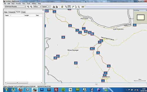
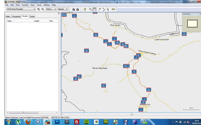
As an example:
Original data from garmin.openstreetmap.nl
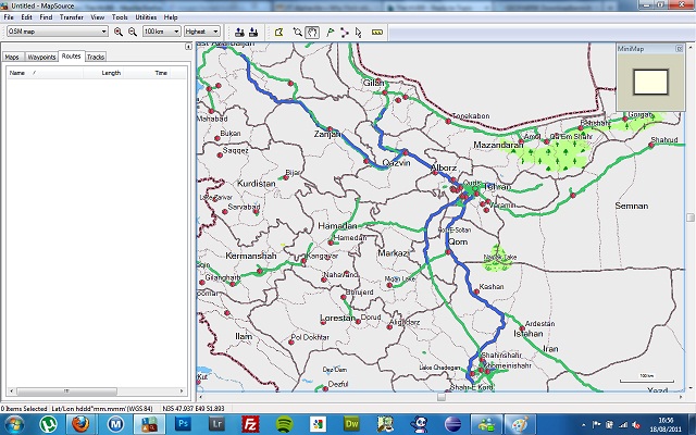
Custom Formatting:
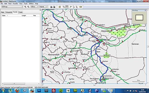
OSM is a life saver, how people found their hotel in the centre of Tehran without it is a complete mystery to me 
__________________
*******************************************
roja45.com
|
18 Aug 2011
|
|
Contributing Member
Veteran HUBBer
|
|
Join Date: Sep 2003
Location: Whangarei, NZ
Posts: 2,214
|
|
Nice job you have done customising the map. I wasn't aware that Geofabrik update their extracts daily. They don't have extracts for most countries in SE Asia, so I never looked into this in detail.
However, what you have done is way beyond what the average user could achieve. A lot of people have difficulty following the instructions to load the pre-made maps into their GPS ...
Interesting comment about the Arabic writing. This shouldn't happen, but I think this may have been caused by incorrect tagging on OSM. Apart from the general support forum for Lambertus' map there is now also a topic on the OSM forum to report problems: Worldwide routable Garmin maps: Missing/incorrect feature requests (Page 1) / Garmin maps / OpenStreetMap Forum
You can have a look at our style and typ files here: /trunk - mkgmap-style-sheets - MkGMap style sheets for http://garmin.openstreetmap.nl - Google Project Hosting
I have teamed up with Lambertus and another OSM 'hacker' to improve the rather poor appearance of the maps, as produced by default by the compiler. We hope to have the maps look more like what you have shown very soon. We also ask that people report incorrect or missing features in the above topic.
|
20 Aug 2011
|
|
Registered Users
HUBB regular
|
|
Join Date: Sep 2009
Posts: 39
|
|
|
Hi Peter,
Nice, I look forward to the results. My main reason to customize was to get major roads and towns to appear at lower zoom levels, and, reading through that forum, that seems to be one of your requirements also.
Let me kow if you need a road test for the middle east, have a Zumo 220 and 660 here.
I tried to take a look at the config you're using but I get a 403, though that's possibly because the internet in Iran is the most heavily filtered I've encountered.
Cheers
__________________
*******************************************
roja45.com
|
20 Aug 2011
|
|
Contributing Member
Veteran HUBBer
|
|
Join Date: Sep 2003
Location: Whangarei, NZ
Posts: 2,214
|
|
|
If you email me I can send you the style and typ files. Otherwise, you can just wait until Lambertus updates his system.
|
26 Aug 2011
|
 |
Registered Users
Veteran HUBBer
|
|
Join Date: Jun 2000
Location: GOC
Posts: 3,364
|
|
Cross link to http://www.horizonsunlimited.com/hub...-america-58899
Free South American GPS maps, some might be similar one of the posts above.
Thanks JediMaster 
cheers
Chris
|
|
Currently Active Users Viewing This Thread: 1 (0 Registered Users and/or Members and 1 guests)
|
|
|
 Posting Rules
|
You may not post new threads
You may not post replies
You may not post attachments
You may not edit your posts
HTML code is Off
|
|
|
|

Check the RAW segments; Grant, your HU host is on every month!
Episodes below to listen to while you, err, pretend to do something or other...

2020 Edition of Chris Scott's Adventure Motorcycling Handbook.
"Ultimate global guide for red-blooded bikers planning overseas exploration. Covers choice & preparation of best bike, shipping overseas, baggage design, riding techniques, travel health, visas, documentation, safety and useful addresses." Recommended. (Grant)

Led by special operations veterans, Stanford Medicine affiliated physicians, paramedics and other travel experts, Ripcord is perfect for adventure seekers, climbers, skiers, sports enthusiasts, hunters, international travelers, humanitarian efforts, expeditions and more.
Ripcord Rescue Travel Insurance™ combines into a single integrated program the best evacuation and rescue with the premier travel insurance coverages designed for adventurers and travel is covered on motorcycles of all sizes.
(ONLY US RESIDENTS and currently has a limit of 60 days.)
Ripcord Evacuation Insurance is available for ALL nationalities.
What others say about HU...
"This site is the BIBLE for international bike travelers." Greg, Australia
"Thank you! The web site, The travels, The insight, The inspiration, Everything, just thanks." Colin, UK
"My friend and I are planning a trip from Singapore to England... We found (the HU) site invaluable as an aid to planning and have based a lot of our purchases (bikes, riding gear, etc.) on what we have learned from this site." Phil, Australia
"I for one always had an adventurous spirit, but you and Susan lit the fire for my trip and I'll be forever grateful for what you two do to inspire others to just do it." Brent, USA
"Your website is a mecca of valuable information and the (video) series is informative, entertaining, and inspiring!" Jennifer, Canada
"Your worldwide organisation and events are the Go To places to for all serious touring and aspiring touring bikers." Trevor, South Africa
"This is the answer to all my questions." Haydn, Australia
"Keep going the excellent work you are doing for Horizons Unlimited - I love it!" Thomas, Germany
Lots more comments here!

Every book a diary
Every chapter a day
Every day a journey
Refreshingly honest and compelling tales: the hights and lows of a life on the road. Solo, unsupported, budget journeys of discovery.
Authentic, engaging and evocative travel memoirs, overland, around the world and through life.
All 8 books available from the author or as eBooks and audio books
Back Road Map Books and Backroad GPS Maps for all of Canada - a must have!
New to Horizons Unlimited?
New to motorcycle travelling? New to the HU site? Confused? Too many options? It's really very simple - just 4 easy steps!
Horizons Unlimited was founded in 1997 by Grant and Susan Johnson following their journey around the world on a BMW R80G/S.
 Read more about Grant & Susan's story
Membership - help keep us going!
Horizons Unlimited is not a big multi-national company, just two people who love motorcycle travel and have grown what started as a hobby in 1997 into a full time job (usually 8-10 hours per day and 7 days a week) and a labour of love. To keep it going and a roof over our heads, we run events all over the world with the help of volunteers; we sell inspirational and informative DVDs; we have a few selected advertisers; and we make a small amount from memberships.
You don't have to be a Member to come to an HU meeting, access the website, or ask questions on the HUBB. What you get for your membership contribution is our sincere gratitude, good karma and knowing that you're helping to keep the motorcycle travel dream alive. Contributing Members and Gold Members do get additional features on the HUBB. Here's a list of all the Member benefits on the HUBB.
|
|
|


 Linear Mode


