


Mexico 2005: Third Annual HU Travellers Meeting
Creel, Copper Canyon, Mexico, Oct 11-14, 2005
As Gerry Elam, USA, said of the Mexico 2003 meeting:
"Thank you Grant and Susan... it was a BLAST! Looking forward to next year already!"
And from Glen Davis,
"Thanks to all involved for a meeting that exceeded all expectations. Well done!"
Comments from the 2004 meeting:
From Mike Torst:
"Grant, I want to thank you, once again, for a great meet! I was in the hands of the pros, and I am still in awe. I remain humbled---thanks again! Oh, and I will CU next year!"
From Jim Donaldson, NC, USA,
"Grant, What can I say. Creel is the perfect place for an HU meet. As my friend Chris Walstow says it's easily accessible from anywhere in North America. It's warm and cool at the same time. The people are friendly and the riding is superb. I look for the meet to grow beyond all expectations as the word spreads. Thanks, Jim D
My pictures and log here."
See you all there!
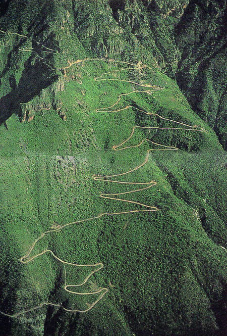
In case you're wondering why you should go, this is only a small part of the road to Batopilas, photographed from a helicopter.
Photo courtesy The 3 Amigos Canyon Expeditions in Creel, Mexico. Check them out for excellent maps and Copper Canyon information, 4wd rentals etc.
In case you missed it, we had well over 100 participants, and we had a great time!
Photos to come, sorry for the delay - I'm moving from Canada to England!
The Plan
The general plan is simple. Show up early, at least by Tuesday, or even better Monday, have a drink, tell some lies, have another drink, eat at a reasonable hour, then slide shows are planned.
2005 speakers:
- Grant Johnson - I will be there, and will give a 3 hour presentation/discussion on "How YOU can do it" probably on Thursday afternoon.
- Dave Smith, USA, around Australia on a 250 Ducati.
- Chris Ratay, USA, around the world multimedia
- Lana Lowe, Canada, en route, Canada to Ushuaia
- Russ Darr, USA, trip preparation
- How about you? Let us know if you have something to show! Volunteers wanted! It's easy and fun, we'll even help you out.
Tech Sessions:
- Grant Johnson, Photo Composition for Travellers - the one everyone SHOULD take, but no one does...
- Tire changing and flat prevention
- Gerardo Ibarra, Mexico, Navigation, GPS101 and map and compass
- Jim Hyde, Rawhyde Adventure Camp, off-road riding tips
- Q & A - how to do it - panel discussion
- Stoves - a big question everyone asks is "What's the best one?" Well bring yours and we'll do a comparison - and find out!
- How about you? Let us know if you have something to show! Volunteers wanted!
Tourist and travel information:
- Humberto Moro, and Dan Toporoski, on the Guadalajara area
- Rosens Rides, Motorcycle Rentals and Tours in Copper Canyon and Mexico
There will be slide shows/videos Tuesday through Thursday nights , so come early and make it a great week!
The Meeting Location for 2005
Creel, Copper Canyon, Mexico
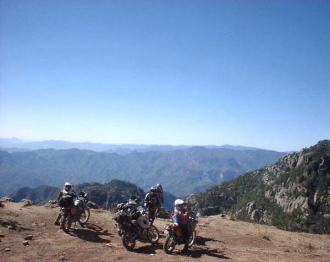
La sierra, Copper Canyon, photo by the Ibarra brothers
Getting There:
Some travellers will be meeting on the USA side of the border and riding down in a group. See the HUBB for details.
Excellent tips and info on everything you need to know about crossing the border into Mexico here, including a big dose of practical information from our Mexico Meeting lead organiser, Gerardo Ibarra.From 2003:
If you'd like someone to ride down and cross the US/Mexico border with, see the thread here on the HUBB.
Note - plan on being at the campground/restaurant for dinner by 6pm at latest! Lots happening in the evening.
From Patrick Moriarty, City Bike, San Francisco, USA
"I spoke with Grant at the HU meeting in Revelstoke, B.C. and he asked if I might outline a few ride routes to the next HU get together in Copper Canyon, Mexico.
Copper Canyon (Barranca del Cobre) Ride Routes
The best route to Copper Canyon depends on where you're coming from and how much time you want to take coming and going. On our ride we were coming from California so a western approach seemed logical. No one I could find back in 1998 had ever done or heard about a western approach to the area. But the roads are there, so this is what we did.
Being old dirt riders we decided to go down Baja and re-visit some old friends, and some of our favourite areas. We spent about 3 days in Baja then hopped the ferry from Santa Rosalia to Guaymas. (Santa Rosalia Ferry info here) I don't know current prices, but in '98 we paid about $60 for a private cabin and a bike. I'm sure things have gone up. It's about a six or seven hour crossing. You can just book a seat, much cheaper.
In Guaymas we headed south about 60 miles on Mex. 15 to Ciudad Obregon. Here you take Mexico 12 east. Look for signs for Yecora, La Junta, Yepachic and Mex. 16. Signs come and go in Mexico but there is really only one road here. Go for about 60 miles till the intersection with Mex. 16. Continue on 16 almost to La Junta junction, turn right towards Creel on Mex. 127. If you're in more of a hurry you can skip Baja and zap interstates on the US side down to Nogales via I-10. At Nogales you pick up Mex. 15 and go all the way to Hermosillo where you head southeast on Mex. 16 all the way to Creel (see above). This route is a day's ride from the border if you're not shy about wasting "valuable resources".
Both Mex. 12 and 16 are good twisty two laners that climb through mountains and take you from the desert to Alpine forests. A great ride up.
Creel is at 8,000 ft. (about 2600 meters) and you start at sea level. You will be in the Sierra so weather is highly unpredictable, but October should be quite nice. (famous last words) For those coming to the Canyon from more southern or eastern approaches it is a pretty short and straight shot from either El Paso or Presidio, Texas to Creel on main Mexican highways.
From El Paso take Mex. 45 south to Chihuahua to Mex. 16 west to the 127 turn off for Creel.
From Presidio take Mex. 16 all the way to the 127 turn off.
Please consult a good map of Mexico to confirm these routes. I am using the maps in the Moon Travel guidebook called Northern Mexico Handbook (including the Copper Canyon) by Joe Cummings. It's a very good guidebook for the area with a useful supplement on the Canyon. Highly Recommended. Also note there may be a number of new roads in and around the Copper Canyon that show as dirt on maps but may now be paved. When I was in CC in 1998 we had breakfast with the head of the state highway division and he outlined a plan for development on the roads that would blow your mind. Luckily in Mexico what is planned rarely becomes a reality. (something about funding?)
For those off road guys, you may be able to ride a dirt road from Copper Canyon to Alamos on the Pacific coast. I know folks who have done it, but the road is sparsely maintained and may be subject to wash outs. This is supposed to be a hoot to do. You follow the road from Divisadero west parallel to the railroad. Somewhere around the aldea of Temoris Viejo you turn off toward Chinipas and head west to Alamos.
Remember, current, well informed local knowledge is always best so check and double check possible routes when you're in the area. At this point CC is so inundated with MOTO-tourists I should think someone from the many guided tours will have up to date info. Then again, they may seek revenge on independent travellers! ;-) City Bike, San Francisco, CA"
From a post by Ian Elseley on the HUBB,
RE: "...dirt road from Copper Canyon to Alamos on the Pacific coast..."
"I rode a good deal of this road recently with a loaded KLR and 80-20 street bias tires and it's really in pretty good condition. The loggers keep it pretty much open. The only problem you're likely to hit is if it rains the rivers fill fast and the rock stretches get (very) slippery. As for it being a hoot... yea... it is."
From Walter Hirales, Mexico,
"For information about the ferry boat from Guaymas to Santa Rosalia visit here or Santa Rosalia Ferry info here.

Global Rescue is the premier provider of medical, security and evacuation services worldwide and is the only company that will come to you, wherever you are, and evacuate you to your home hospital of choice.
Additionally, Global Rescue places no restrictions on country of citizenship - all nationalities are eligible to sign-up! Travel medical insurance is also available, currently the limit is 90 days. (TIP: For Evac insurance - Click Multiple Trips and 365 days to get year long insurance.)
![]()
Ripcord Rescue Travel Insurance™ combines into a single integrated program the best evacuation and rescue with the premier travel insurance coverages designed for adventurers.
Led by special operations veterans, Stanford Medicine affiliated physicians, paramedics and other travel experts, Ripcord is perfect for adventure seekers, climbers, skiers, sports enthusiasts, hunters, international travelers, humanitarian efforts, expeditions and more.
Ripcord travel protection is now available for ALL nationalities, and travel is covered on motorcycles of all sizes! NOTE: Travel medical insurance currently has a limit of 90 days.
Member login
Announcements
Thinking about traveling? Not sure about the whole thing? Watch the HU Achievable Dream Video Trailers and then get ALL the information you need to get inspired and learn how to travel anywhere in the world!
Have YOU ever wondered who has ridden around the world? We did too - and now here's the list of Circumnavigators!
Check it out now, and add your information if we didn't find you.
Are you an Overland Adventure Traveller?
Does the smell of spices wafting through the air make you think of Zanzibar, a cacophony of honking horns is Cairo, or a swirl of brilliantly patterned clothing Guatemala? Then this is the site for you!
Hosted by Grant and Susan Johnson, RTW 1987-1998
Next HU Events
HU Event and other updates on the HUBB Forum "Traveller's Advisories" thread.
ALL Dates subject to change.
2024:
- California: April 18-21
- Virginia: April 25-28
- Germany Summer: May 9-12
- Québec: May 17-19
- Bulgaria Mini: July 5-7
- CanWest: July 11-14
- Switzerland: August 15-18
- Romania: August 30-Sept 1
- Ecuador: August 24-25
- Austria: September 12-15
- France: September 20-22
- Queensland is back! Oct 4-7
- Germany Autumn: Oct 31-Nov.3
- South Africa: November
Add yourself to the Updates List for each event!
Questions about an event? Ask here
HU Achievable Dream is Online
and available now to stream on Vimeo!
ALL 15 chapters of the HU Achievable Dream Guide are available to download on Vimeo!

Binge watch over 18 hours of inspiring, informative and entertaining stories and tips from 150 travellers!
"a cross between entertaining stories, tech tips, and reference guide"
"A timeless introduction to Motorcycle Adventure Travel!"
Originally launched as a 7 DVD set, The Achievable Dream series can now be downloaded anywhere. OVER 18 hours of solid info take up zero space in your panniers. How convenient!
Books

All the best travel books and videos listed and often reviewed on HU's famous Books page. Check it out and get great travel books from all over the world.
NOTE: As an Amazon Affiliate we earn from qualifying purchases - thanks for your help supporting HU when you start from an HU Amazon link!