 |
|

7 Oct 2010
|
 |
Contributing Member
Veteran HUBBer
|
|
Join Date: Jul 2005
Location: Wirral, England.
Posts: 5,656
|
|
|
Is there fuel on the "railway" road south from Wadi Halfa, Sudan ??
This has probably been covered but i cant find it with this crap internet in Egypt.
Once we are in Sudan, there is a sand road that follows the railway tracks south of Waldi Halfa. Now, is there fuel down there ?? How long before a petrol station ???
Cheers, Ted
__________________
Did some trips.
Rode some bikes.
Fix them for a living.
Can't say anymore.
|
7 Oct 2010
|
 |
-
Veteran HUBBer
|
|
Join Date: Apr 2006
Location: WWW
Posts: 2,341
|
|
Ted - using GE, garmin worldmap, Smellybiker map, and my old huge coffee table sized atlas, I guess between 370kms to 400kms-
there should be fuel at karman Uzul aka Kerma .
Having zoomed as much as possible, this looks a very possible 'African' fuel stop- by its position, shape , I'd lay some odds on it being one.
Ted- this is an educated guess and not based on anything else-
here N19 38.021 E30 24.422
Failing that, next sizeable town further south seems to be Dongola at
N19 10.100 E30 28.032 which I guess again, is another 60kms
If you say it's a trail then your fule consumption can more than double especially if it's sand- be prepared or better still, carry some extra and also get a cheapo container which another car/truck may carry (and could make off with....  )
and think about water too...
Just my 2pence
Have a ball!
Last edited by Bertrand; 2 Mar 2016 at 16:18.
|
8 Oct 2010
|
 |
Registered Users
Veteran HUBBer
|
|
Join Date: Apr 2001
Location: Norway
Posts: 1,379
|
|
Kerma is not by the railroad it's along the Nile.
The first place you can expect to get petrol along the railroad is at Abu Hamed which is also 370 kms from Wadi Halfa.
The route is pretty hard (eeeh or soft) an option is to follow the Nile to Abu Dom and then continue east from Abu Dom, or continue south from Abu Dom.
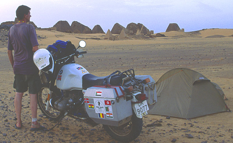
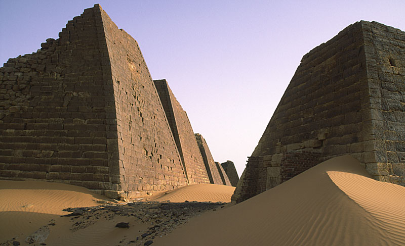
If you fancy some more pyramids you can visit the royal city (Meroe). The pyramids are small but it's a nice peaceful place. You are supposed to get a permit to visit them in Khartoum but if you come from the north they will normally let you in.
|
8 Oct 2010
|
|
-
Veteran HUBBer
|
|
Join Date: Apr 2006
Location: WWW
Posts: 2,341
|
|
Ted- I thought you meant going down by the Nile!-
Alibaba is right if you are heading SSE towards Abu Hamed ( N19 32.048 E33 19.810) and the distance seems to work out pretty much the same.
Nice pictures Alibaba - did you keep waypoints you could post up to help Ted?
BTW Ted-
did you ever buy the maps 'Tracks for Africa' you asked about a while back? and you never said if you had a gps or not- have you?
I've just read up on their website here
and look what it says
"Our maps cover more than 85,000 points of interest ranging from activities, attractions to fuel stops and emergency services. We have accommodation such as hotels, guest lodges, backpackers as well as the most comprehensive listing of camp sites in Africa."
Map list available to buy is here
750 Sth African Rand = about £68 seems very reasonable for the full set
|
8 Oct 2010
|
|
Registered Users
Veteran HUBBer
|
|
Join Date: Apr 2001
Location: Norway
Posts: 1,379
|
|
Quote:
Originally Posted by Bertrand

Nice pictures Alibaba - did you keep waypoints you could post up to help Ted?
|
Thanks, sorry no waypoints but the pyramids are close to Meroe and hard to miss. To add up to the confusion there is also a place called Merowe which looks interesting but I haven't been there. Next time - inshallah...
As you probably have hard before the Sudanese people are extremely friendly, this guys literally gave me a bed for the night:

The local girls fancied bikers:


The pictures are just to waste Teds poor Egyptian bandwidth.
|
8 Oct 2010
|
|
-
Veteran HUBBer
|
|
Join Date: Apr 2006
Location: WWW
Posts: 2,341
|
|
" The pictures are just to waste Teds poor Egyptian bandwidth."
Ted will be pleased!! 
|
8 Oct 2010
|
|
Contributing Member
Veteran HUBBer
|
|
Join Date: Jul 2005
Location: Wirral, England.
Posts: 5,656
|
|
|
Thanks so much !!! Looks like i'll be strapping bottles of fuel all over my bike then and prey there is fuel at abu hamed...
bertrand, yes I have the t4a maps but they are not working with my 2610 for some reason. All sattelites just dissapear. They dont actually seem THAT much better than base map up north.
OSM maps are BRILLIANT (although also wont work with my 2610 atm)... very detailed and routable throughout Egypt.
__________________
Did some trips.
Rode some bikes.
Fix them for a living.
Can't say anymore.
|
8 Oct 2010
|
|
-
Veteran HUBBer
|
|
Join Date: Apr 2006
Location: WWW
Posts: 2,341
|
|
Ted- I've just come back from a friend's house and she has the T4 maps-
Looking at those where you are it does show roads/trails/fuel stations, accomodation etc.
If your satellites disappear - it seems there could be something dodgy with your GPS- maps are not connected to the gps's ability to receive signals.
You may, (stress on the 'may') have to do a unit reset.
When you power up, it shopuld display the software version - the latest is 4.8-
The manual (4MB) is available from here
Careful though- make sure you have your maps, waypoints etc backed up before you do a full reset
As I do not know your unit, I just spoke to Garmin UK. Here is the info you might need:
1- to do a SOFT reset (does not delete your maps or waypoints) When unit is OFF, Press and HOLD the power button for 20 seconds
2- to do a HARD reset- when the unit if OFF, HOLD Page and MENU keys together, press the power button and keep holding Page and Menu- a warning will come on screen to ask you if you really want to do this. This erases EVERYTHING AND RESETS UNIT TO FACTORY DEFAULT- You may need to download and update the unit's software to version 4.8 (latest for your 2610)
Update your unit for free using WebUpdater software here
Last edited by Bertrand; 8 Oct 2010 at 17:43.
|
8 Oct 2010
|
|
-
Veteran HUBBer
|
|
Join Date: Apr 2006
Location: WWW
Posts: 2,341
|
|
BTW... that's 2  s you now owe me
|
8 Oct 2010
|
|
Contributing Member
Veteran HUBBer
|
|
Join Date: Jul 2005
Location: Wirral, England.
Posts: 5,656
|
|
|
I'll be sure to send you over a few bottles of my "Sledgehammer reserve" homemade wine when I get back... It's pretty good ya know !!
9/10 people who pass out while drinking it will agree !!
__________________
Did some trips.
Rode some bikes.
Fix them for a living.
Can't say anymore.
|
8 Oct 2010
|
|
Contributing Member
Veteran HUBBer
|
|
Join Date: Jul 2005
Location: Wirral, England.
Posts: 5,656
|
|
Yer, I have looked at the maps. They do have some detail but no way as good as the OSM...
This issue with the maps is really pissing me off. My other maps work just fine. Like you say, I cant see how the maps are related to the signal but I can be staring at the gps info showing no sats then pop the card out while its still powered on and INSTANTLY, loads of sats will register. I put the card back it and they all drop off then dissapear... 
Im going to try a unit reset. I'll copied down the useful waypoints i've collected.
I have 4.8 installed !!
Quote:
Originally Posted by Bertrand
Ted- I've just come back from a friend's house and she has the T4 maps-
Looking at those where you are it does show roads/trails/fuel stations, accomodation etc.
If your satellites disappear - it seems there could be something dodgy with your GPS- maps are not connected to the gps's ability to receive signals.
You may, (stress on the 'may') have to do a unit reset.
When you power up, it shopuld display the software version - the latest is 4.8-
As per your instructions, i cant see how to hold the power button as it doesnt have one, just a switch on the side for on/off !
Anyway, ill have a play with this tomorrow... Thanks so much again !!
The manual (4MB) is available from here
Careful though- make sure you have your maps, waypoints etc backed up before you do a full reset
As I do not know your unit, I just spoke to Garmin UK. Here is the info you might need:
1- to do a SOFT reset (does not delete your maps or waypoints) When unit is OFF, Press and HOLD the power button for 20 seconds
2- to do a HARD reset- when the unit if OFF, HOLD Page and MENU keys together, press the power button and keep holding Page and Menu- a warning will come on screen to ask you if you really want to do this. This erases EVERYTHING AND RESETS UNIT TO FACTORY DEFAULT- You may need to download and update the unit's software to version 4.8 (latest for your 2610)
Update your unit for free using WebUpdater software here
|
__________________
Did some trips.
Rode some bikes.
Fix them for a living.
Can't say anymore.
|
9 Oct 2010
|
|
-
Veteran HUBBer
|
|
Join Date: Apr 2006
Location: WWW
Posts: 2,341
|
|
That 'sledgehammer' sounds way too dangerous for me!! & thanks for your email
From what you say Ted, it sounds like you've narrowwed it down to that memory card- you might want to check the following:
1) could it be that memory card has a problem? - you might want to save what is on there on another media and format the memory card which will erase any possible duff stuff
2) Do you store any other non-map related files on that memory card ? which could interfere with the gps?
3) too many maps loaded at once causing memory overflow?
BTW, once you have done the reset or software update, the gps needs a clear view of sky in an open space outside for about 30 minutes to 're-aquire' itself.
Look at pics below taken from your manual - might help- have you damaged it or is it the right type? Type I or Type II CompactFlash (CF) storage cards. Is it inserted correctly? (sorry if this sounds daft!)
And look at the warning about the type of card! therein might be your problem.
Last edited by Bertrand; 2 Mar 2016 at 16:18.
|
9 Oct 2010
|
|
-
Veteran HUBBer
|
|
Join Date: Apr 2006
Location: WWW
Posts: 2,341
|
|
|
Just another thought-
This is how you select or deselect loaded maps-
Last edited by Bertrand; 2 Mar 2016 at 16:18.
|
9 Oct 2010
|
|
Contributing Member
Veteran HUBBer
|
|
Join Date: Jul 2005
Location: Wirral, England.
Posts: 5,656
|
|
|
Well I did a HARD reset and no improvement.. I have two CF cards so im going to try the other one and see if it helps. Pretty sure they're the same type though.. The unit will read the maps fine. I can view them, navigate, go to etc and they even route and work for a few mins before all the sats dissapear... Its the wierdest problem ever !
Iv tried all sorts of things with selecting/deselecting maps etc..
If it's not the cards then im lost !
__________________
Did some trips.
Rode some bikes.
Fix them for a living.
Can't say anymore.
|
9 Oct 2010
|
|
-
Veteran HUBBer
|
|
Join Date: Apr 2006
Location: WWW
Posts: 2,341
|
|
 if you're lost, the Red Sea is .... on your left! just point towards the sun in the morning and you'll be fine!
(fingers crossed it's the card)
If the satellites disappear with that card, then there must be a gremlin on the card-
|
|
Currently Active Users Viewing This Thread: 1 (0 Registered Users and/or Members and 1 guests)
|
|
|
 Posting Rules
|
You may not post new threads
You may not post replies
You may not post attachments
You may not edit your posts
HTML code is Off
|
|
|
|

Check the RAW segments; Grant, your HU host is on every month!
Episodes below to listen to while you, err, pretend to do something or other...

2020 Edition of Chris Scott's Adventure Motorcycling Handbook.
"Ultimate global guide for red-blooded bikers planning overseas exploration. Covers choice & preparation of best bike, shipping overseas, baggage design, riding techniques, travel health, visas, documentation, safety and useful addresses." Recommended. (Grant)

Ripcord Rescue Travel Insurance™ combines into a single integrated program the best evacuation and rescue with the premier travel insurance coverages designed for adventurers.
Led by special operations veterans, Stanford Medicine affiliated physicians, paramedics and other travel experts, Ripcord is perfect for adventure seekers, climbers, skiers, sports enthusiasts, hunters, international travelers, humanitarian efforts, expeditions and more.
Ripcord travel protection is now available for ALL nationalities, and travel is covered on motorcycles of all sizes!
What others say about HU...
"This site is the BIBLE for international bike travelers." Greg, Australia
"Thank you! The web site, The travels, The insight, The inspiration, Everything, just thanks." Colin, UK
"My friend and I are planning a trip from Singapore to England... We found (the HU) site invaluable as an aid to planning and have based a lot of our purchases (bikes, riding gear, etc.) on what we have learned from this site." Phil, Australia
"I for one always had an adventurous spirit, but you and Susan lit the fire for my trip and I'll be forever grateful for what you two do to inspire others to just do it." Brent, USA
"Your website is a mecca of valuable information and the (video) series is informative, entertaining, and inspiring!" Jennifer, Canada
"Your worldwide organisation and events are the Go To places to for all serious touring and aspiring touring bikers." Trevor, South Africa
"This is the answer to all my questions." Haydn, Australia
"Keep going the excellent work you are doing for Horizons Unlimited - I love it!" Thomas, Germany
Lots more comments here!

Diaries of a compulsive traveller
by Graham Field
Book, eBook, Audiobook
"A compelling, honest, inspiring and entertaining writing style with a built-in feel-good factor" Get them NOW from the authors' website and Amazon.com, Amazon.ca, Amazon.co.uk.
Back Road Map Books and Backroad GPS Maps for all of Canada - a must have!
New to Horizons Unlimited?
New to motorcycle travelling? New to the HU site? Confused? Too many options? It's really very simple - just 4 easy steps!
Horizons Unlimited was founded in 1997 by Grant and Susan Johnson following their journey around the world on a BMW R80G/S.
 Read more about Grant & Susan's story
Membership - help keep us going!
Horizons Unlimited is not a big multi-national company, just two people who love motorcycle travel and have grown what started as a hobby in 1997 into a full time job (usually 8-10 hours per day and 7 days a week) and a labour of love. To keep it going and a roof over our heads, we run events all over the world with the help of volunteers; we sell inspirational and informative DVDs; we have a few selected advertisers; and we make a small amount from memberships.
You don't have to be a Member to come to an HU meeting, access the website, or ask questions on the HUBB. What you get for your membership contribution is our sincere gratitude, good karma and knowing that you're helping to keep the motorcycle travel dream alive. Contributing Members and Gold Members do get additional features on the HUBB. Here's a list of all the Member benefits on the HUBB.
|
|
|


 Linear Mode


