 |
|

26 Apr 2014
|
|
Registered Users
HUBB regular
|
|
Join Date: Jan 2014
Location: San Francisco, CA
Posts: 53
|
|
|
digital maps for Mauritania
Hi folks,
am in midst of planning for 4x4 sahara and west africa. I have a panasonic toughbook with nRoute and GPS. Have Olaf map for Morocco, but am looking for something for Mauritania. We plan to spend time exploring Adrar and Aoukar regions and would like info on any maps, routes/tracks etc. What have other people found? I understand that Viagens4x4 has a map that covers Mauri/Mali/Senegal. Has anyone tried this one? WHat about any good sources for digitized russian or other maps?
thanks, Rick.
|
27 Apr 2014
|
|
Registered Users
Veteran HUBBer
|
|
Join Date: Aug 2012
Location: Australia
Posts: 1,131
|
|
|
Digital maps ?
There are at lest 2 kinds
Raster .. like a photo .. think of it as a photo of a paper map .. you can zoom in .. like using a magnifying glass .. this is waht you have from the old russian maps.
Vector .. this is what you have with Olaf's map, zooming in can get you more detail, zooming out stuff disappears so your not just seeing black ants swarming over the screen.
These are two different beasts and need separate software to use them.
----------------------
The Russian maps used to be available on the web .. free but tedious. You could also buy a CD with them on it. IIRC mapstore?
For vector maps likes Olaf's map use Open Street Map (OSM) - free and world wide coverage. May not have as much detail as you want .. but then the commercial maps may not have that either!
|
27 Apr 2014
|
|
Registered Users
New on the HUBB
|
|
Join Date: Apr 2014
Posts: 1
|
|
|
Digital maps for iPhone iPad - Mauritania
Hi
I just crossed Mauritania using offline maps for iPhone/iPad.
They are quite reliable, even the free version. So if you have a tablet the App is called MapsWithMe.
You need to zoom in a country and download full street view.
Regards
|
27 Apr 2014
|
 |
-
Veteran HUBBer
|
|
Join Date: Apr 2006
Location: WWW
Posts: 2,341
|
|

For off the tarmac- I still have not found any better maps than the Russian topo ones- for those areas- These, of course are well out of date by a long stretch - but still the best. Unless some kind soul comes along and gives me a 'heads up' for a better one !
Warin- you may not have tried the 'Soviet military maps' app? they are very easy to install BUT they are slow to download-- for example- Mauritania at max zoom took 16 hours to download- so this best done on your fast broadband at home before you go. screen shot below of Garmin's Monterra showing East of Atar.
Quote:
Originally Posted by Warin

Vector and Raster maps- These are two different beasts and need separate software to use them.
|
- may I correct you? no separate software is needed to use maps in either format on Garmin's Montana series, Monterra and the handhelds 62S and 64ST - The geo-referencing of each image takes ages to do though.
I did a talk at Hubb Germany on how to do this-
Note: of all 4 units above, only the Monterra is capable of running Android hence the Soviet Military map Android App. You can use images available free on the web (or GE screen shots) but you will need to geo-reference each one before use and maybe this is what Warin refers to as 'free but tedious' - which I agree with- it does take ages to do but it is do-able!
and don't forget one of each of those!
Last edited by Bertrand; 2 Mar 2016 at 16:16.
|
28 Apr 2014
|
|
Registered Users
Veteran HUBBer
|
|
Join Date: Aug 2012
Location: Australia
Posts: 1,131
|
|
Quote:
Originally Posted by Bertrand
- may I correct you? no separate software is needed to use maps in either format on Garmin's Montana series, Monterra and the handhelds 62S and 64ST - The geo-referencing of each image takes ages to do though.
|
Hi. Yes .. I'd call this a 'special case'
The software on those is set up to handle both 'formats'.
On a PC I use
Garmins "Mapsource" for the vector maps (a considerable collection of these)
and
"Oziexplorer" for the raster maps ... (again a considerable collection! Including the Russian maps)
---------------
I've recently got an androd phone .. it presently has OsmAnd for vector maps and Androzic for the raster ... I'll have a look at 'Soviet military maps' app later. I'd prefer not to have to download all the maps I've already got though! 
Still using my Garmin 60Cx.. see no reason to update at this time .. I'd like to be able to use the raster maps too .. but for the $ I cannot see throwing the 60 away. 
|
29 Apr 2014
|
|
Registered Users
HUBB regular
|
|
Join Date: Aug 2002
Location: Bialystok, Poland
Posts: 89
|
|
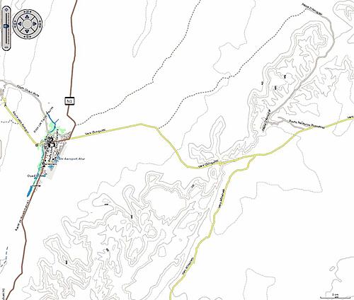
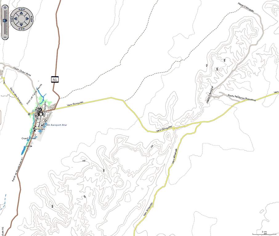
I wonder how good is OSM topo, comparing to Soviet maps. Anyone has compared the two?
e.g. East of Atar on OSM
Same area render in Base Camp:
|
30 Apr 2014
|
 |
Super Moderator
Veteran HUBBer
|
|
Join Date: Jun 2000
Posts: 4,813
|
|
|
Nice map Janusz, enjoyed scanning that as an alternative to Google.
Only problem is I haven't got enough hair left to pull out trying to make it work on my Nuvi. Perhaps that's a good thing.
Depends what you're doing off course, but in the desert away from main pistes I'd rely on paper with GPS of course. And for me IGNs @ 1m do the job.
Or 200k if needed - all digitised as rasters on CD (below).
The IGN 200s are works of art (below). I would not describe Soviet maps like that.
Ch
|
2 May 2014
|
|
Registered Users
Veteran HUBBer
|
|
Join Date: Feb 2012
Posts: 828
|
|
iPad and MotionX let you use different Mapsources like Google Road, Google Satellite, Google Hybrid View - what you can download before you go.
In Mauretania you can use it offline. You can too use other Mapsources like Openstreetmaps, Bing Road, Satellite. You can switch these downloaded Mapsources anytime, to look what gives you the best and most detailed overview.
We use this solution for our transafrica, very powerful! Specially between Cameroon till Angola there is no alternative to satellite hybrid view - this was very helpful.

Also to find a "quiet" spot for a wildcamp, the satellite view is the best you can get.
Offroad Navigation with MotionX
4x4tripping: Offroad Navigation mit MotionX HD (iPad)
MotionX the "custom Map" option
4x4tripping: Offroad Navigation mit MotionX - die neue "Custom Maps" Funktion
MotionX is fine for offroad navigation and orientation. You can see where you are, see where you was (trackrecording). It has no point to point Navigation, so it cant tell you when you had to go left or right.
For this you better use a road navigation app like TomTom Marocco. It covers too Mauretania and brings you a well sorted POI Database like ATMs, Fuel stations, Police who can be handy too.
The solution like showed here, just works on Apples iPhone or iPad. You will find a way with Android, but never so easy like showed here..
Surfy
|
12 May 2014
|
|
Registered Users
HUBB regular
|
|
Join Date: Jan 2014
Location: San Francisco, CA
Posts: 53
|
|
Thanks everyone.
A few questions:
- Chris, what is a source for the digitized IGNs?
- what is source for the Russian maps online?
- how do I get the topo OSM download?
I came across the following 1:1,000,000 Operational Navigation Chart from u of texas archive:
http://www.lib.utexas.edu/maps/onc/t...322829_j_2.jpg
On this map there appears to be a piste from Oudane south east to the road near Tichit. I have seen GPS coordinates somewhere that seem to follow this roughly (can't remember where I saw them). Is anyone aware of such a route?
Less than 6 months to departure!!! Getting excited!
Rick
|
12 May 2014
|
|
Super Moderator
Veteran HUBBer
|
|
Join Date: Jun 2000
Posts: 4,813
|
|
Quote:
|
- Chris, what is a source for the digitized IGNs?
|
Darrs in Munich last time I looked, or bootleg copies of Darrs
Quote:
|
- what is source for the Russian maps online?
|
Strictly speaking 'Soviet'. I thought Touratech bought them all off a guy called Quo Vadis and called them TTQV. Also available as bootleg.
Maps of the Sahara | Sahara Overland
Quote:
|
- how do I get the topo OSM download?
|
Start somewhere here I suppose. Then it gets complicated.
If you're scanning Texas archives you may find US TPC (1:500k scale) better than ONC 1 millions.
But both ONC/TPC are pilot maps, not so useful for ground info (anything that looks like a track becomes a piste without differentiation).
Don't know of that route, maybe a Paris-Dakar stage or a route in Cyril Ribas' book - Mauritanie au GPS. Looks quite duney up north.
Ch
|
12 May 2014
|
|
Registered Users
Veteran HUBBer
|
|
Join Date: Jul 2011
Location: Ljubljana, Slovenia
Posts: 104
|
|
@rkubin999
My Italian friend explained to me that is possible direct route from Ouadane over the dunes SE to Tichit. No piste at all! You must be very well supplied and experienced driver. You can expect to find deep and soft sand not driving more than few km's per such day. I can ask him in how many day's he passed through and his recomended supplies.
Piste heading East just before Ouadane, I think goes around the Guelb er Richat. Locals said that this piste is used by "Societe" guys from nearby mine ???

Thomas
|
15 May 2014
|
|
Registered Users
HUBB regular
|
|
Join Date: Jan 2014
Location: San Francisco, CA
Posts: 53
|
|
Quote:
Originally Posted by Whiskey
@rkubin999
My Italian friend explained to me that is possible direct route from Ouadane over the dunes SE to Tichit. No piste at all! You must be very well supplied and experienced driver. You can expect to find deep and soft sand not driving more than few km's per such day. I can ask him in how many day's he passed through and his recomended supplies.
Piste heading East just before Ouadane, I think goes around the Guelb er Richat. Locals said that this piste is used by "Societe" guys from nearby mine ???
Thomas |
Hi Thomas- thanks for the note. Yes, interested in info from your friend on days required and supplies. If he has any GPS coords that would be great as well.
Rick.
|
16 May 2014
|
|
Registered Users
New on the HUBB
|
|
Join Date: Nov 2004
Location: Bristol UK
Posts: 11
|
|
|
Garmin Quest and Quest 2
Both work in the World Maps, 
Rich... 
|
|
Currently Active Users Viewing This Thread: 1 (0 Registered Users and/or Members and 1 guests)
|
|
|
 Posting Rules
|
You may not post new threads
You may not post replies
You may not post attachments
You may not edit your posts
HTML code is Off
|
|
|
|

Check the RAW segments; Grant, your HU host is on every month!
Episodes below to listen to while you, err, pretend to do something or other...

2020 Edition of Chris Scott's Adventure Motorcycling Handbook.
"Ultimate global guide for red-blooded bikers planning overseas exploration. Covers choice & preparation of best bike, shipping overseas, baggage design, riding techniques, travel health, visas, documentation, safety and useful addresses." Recommended. (Grant)

Ripcord Rescue Travel Insurance™ combines into a single integrated program the best evacuation and rescue with the premier travel insurance coverages designed for adventurers.
Led by special operations veterans, Stanford Medicine affiliated physicians, paramedics and other travel experts, Ripcord is perfect for adventure seekers, climbers, skiers, sports enthusiasts, hunters, international travelers, humanitarian efforts, expeditions and more.
Ripcord travel protection is now available for ALL nationalities, and travel is covered on motorcycles of all sizes!
What others say about HU...
"This site is the BIBLE for international bike travelers." Greg, Australia
"Thank you! The web site, The travels, The insight, The inspiration, Everything, just thanks." Colin, UK
"My friend and I are planning a trip from Singapore to England... We found (the HU) site invaluable as an aid to planning and have based a lot of our purchases (bikes, riding gear, etc.) on what we have learned from this site." Phil, Australia
"I for one always had an adventurous spirit, but you and Susan lit the fire for my trip and I'll be forever grateful for what you two do to inspire others to just do it." Brent, USA
"Your website is a mecca of valuable information and the (video) series is informative, entertaining, and inspiring!" Jennifer, Canada
"Your worldwide organisation and events are the Go To places to for all serious touring and aspiring touring bikers." Trevor, South Africa
"This is the answer to all my questions." Haydn, Australia
"Keep going the excellent work you are doing for Horizons Unlimited - I love it!" Thomas, Germany
Lots more comments here!

Diaries of a compulsive traveller
by Graham Field
Book, eBook, Audiobook
"A compelling, honest, inspiring and entertaining writing style with a built-in feel-good factor" Get them NOW from the authors' website and Amazon.com, Amazon.ca, Amazon.co.uk.
Back Road Map Books and Backroad GPS Maps for all of Canada - a must have!
New to Horizons Unlimited?
New to motorcycle travelling? New to the HU site? Confused? Too many options? It's really very simple - just 4 easy steps!
Horizons Unlimited was founded in 1997 by Grant and Susan Johnson following their journey around the world on a BMW R80G/S.
 Read more about Grant & Susan's story
Membership - help keep us going!
Horizons Unlimited is not a big multi-national company, just two people who love motorcycle travel and have grown what started as a hobby in 1997 into a full time job (usually 8-10 hours per day and 7 days a week) and a labour of love. To keep it going and a roof over our heads, we run events all over the world with the help of volunteers; we sell inspirational and informative DVDs; we have a few selected advertisers; and we make a small amount from memberships.
You don't have to be a Member to come to an HU meeting, access the website, or ask questions on the HUBB. What you get for your membership contribution is our sincere gratitude, good karma and knowing that you're helping to keep the motorcycle travel dream alive. Contributing Members and Gold Members do get additional features on the HUBB. Here's a list of all the Member benefits on the HUBB.
|
|
|


 Linear Mode


