 |

28 Dec 2012
|
|
Gold Member
HUBB regular
|
|
Join Date: Dec 2009
Location: Reno, Nevada, USA
Posts: 24
|
|
|
Vladivostok to Khabarovsk
Trying to determine mileage from Vladivostok/Khabarovsk using maps, Internet mileage programs, Google Earth etc. I get the mileage anywhere from 390 to 485. Any suggestions as to how to determine accurate mileage between cities in Russia?
|
28 Dec 2012
|
|
Lifetime Member
Veteran HUBBer
|
|
Join Date: Sep 2009
Location: Australia
Posts: 365
|
|
|
For what its worth my on the road mileage (inc a little bit of driving around in each town) was 700 km (approx 430 miles).
I found getting distances from a Russian road atlas the reasonably accurate and Google usually hopeless
|
28 Dec 2012
|
|
Gold Member
Veteran HUBBer
|
|
Join Date: Jan 2002
Location: Toronto, Canada
Posts: 2,125
|
|
Doug:
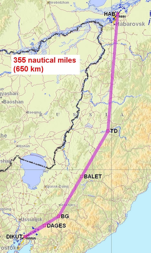
I have never traveled that route by land, however, I fly between those two cities frequently - about 4 or 5 times a year. The image below shows the airway route, and it is 355 nautical miles (about 650 km). Vladivostok airport is in the village of Artom, about 50 km north of Vladivostok proper, so add another 50 km to the aeronautical route to get to downtown UHWW.
Based on that, I think the 'over the road' distance would be no less than 700 km.
For what it's worth, the first 100 nm going south of Khabarovsk consists of fairly flat farmland. There are no big population centers along the way, but it appears that there is sufficient population there that you should not have any problems getting fuel, food, etc. The roads look pretty solid, and there is cell phone coverage everywhere. But, as soon as you get into the hilly areas (anywhere on the map below that shows hills), settlements become few and far between.
The area under the airway between the TD and the BG non-directional beacons is mountainous, forested, and very thinly populated.
I am going to guess that if you followed the roads that more or less parallel the border with China, you would find those areas populated in the same manner as the first 100 nm south of Khabarovsk, because the topography is more or less the same - flat, and suited to large-scale farming. I've never had the opportunity to fly off-airways, though, so that is just speculation.
Khabarovsk is a fairly pleasant city, with good infrastructure and services.
Michael
UHHH to UHWW by low-level airways
|
29 Dec 2012
|
|
Gold Member
HUBB regular
|
|
Join Date: Dec 2009
Location: Reno, Nevada, USA
Posts: 24
|
|
|
Martin:
Thanks for the prompt reply and information.
Where can one buy a Russian Road Atlas in the U.S.?
|
29 Dec 2012
|
|
Gold Member
HUBB regular
|
|
Join Date: Dec 2009
Location: Reno, Nevada, USA
Posts: 24
|
|
|
Russia - Road Miles
Martin:
Thanks for the prompt reply and information.
Where can one buy a Russian Road Atlas in the U.S.?
Rgds./Doug
|
29 Dec 2012
|
|
Gold Member
HUBB regular
|
|
Join Date: Dec 2009
Location: Reno, Nevada, USA
Posts: 24
|
|
|
Russia Road Miles
Michael:
Thanks for your insight.
Rgds./Doug
Quote:
Originally Posted by PanEuropean

Doug:
I have never traveled that route by land, however, I fly between those two cities frequently - about 4 or 5 times a year. The image below shows the airway route, and it is 355 nautical miles (about 650 km). Vladivostok airport is in the village of Artom, about 50 km north of Vladivostok proper, so add another 50 km to the aeronautical route to get to downtown UHWW.
Based on that, I think the 'over the road' distance would be no less than 700 km.
For what it's worth, the first 100 nm going south of Khabarovsk consists of fairly flat farmland. There are no big population centers along the way, but it appears that there is sufficient population there that you should not have any problems getting fuel, food, etc. The roads look pretty solid, and there is cell phone coverage everywhere. But, as soon as you get into the hilly areas (anywhere on the map below that shows hills), settlements become few and far between.
The area under the airway between the TD and the BG non-directional beacons is mountainous, forested, and very thinly populated.
I am going to guess that if you followed the roads that more or less parallel the border with China, you would find those areas populated in the same manner as the first 100 nm south of Khabarovsk, because the topography is more or less the same - flat, and suited to large-scale farming. I've never had the opportunity to fly off-airways, though, so that is just speculation.
Khabarovsk is a fairly pleasant city, with good infrastructure and services.
Michael
UHHH to UHWW by low-level airways
|
|
29 Dec 2012
|
|
Registered Users
Veteran HUBBer
|
|
Join Date: Aug 2012
Location: Australia
Posts: 1,131
|
|
 km vs miles...
You find Russia is a km country so miles won't be of much use there ...
100 miles = 161 km.
You need to start thinking in km  - easy once you get into to it. All the signs will be in km (and cyrillic just to add to the confusion)
--------------
A straight line between the two is ~ 650km (~400 miles). So the road distance will be more. Probably a lot more. Adding say 30% could be good if not too twisty. I'd plan on 2 days travel. 
Some experience?
Accurate mileage? Well the map may have been accurate when it was compiled, but since then the road has been realigned. Not uncommon. Especially for unsealed roads! Take a look at the date of the map... and then think of that as the date it was printed, the drawing date would have been before that and the data date before that... its old when new! And then add it the side trips you want to do to get to the top of the hill on the side for a good view/photo... The distances and even the road directions are guides only, what you get in practice is something else. If that were not the case you could simulate it on a computer and not leave home at all 
|
29 Dec 2012
|
|
Registered Users
Veteran HUBBer
|
|
Join Date: Feb 2010
Location: West Midlands ,UK
Posts: 158
|
|
|
I rode this a few years ago, all the guy's here are on the ball and giving good advice , my guess would be around 750 -800 KM and it is a 2 day trip.
I cannot be more accurate as we took a detour along the coast from Vladivostok and looped back into the M60 north of the airport , at that time the road was under construction from the airport to Vlad and was very rough and busy.
The new road tends to bypass villages and towns , so if you need help supplies ,food fuel don't be put off going down a dirt road to what looks like an old wild west wooden shanty town . Saying that, there are plenty of fuel stops along the main road , our rule was never pass one by, always top up.
Learn cyrillic, my buddy did and i just thought, be ok i'll get by, but after the first day on the road i realised , i didn't have a clue what the signs meant, but i soon started to learn.
Get a Russian map, as an english version would just add more confusion, we bought ours in Vladivostok .
Could i ask why you are so interested in accurate road milage ? If it's fuel as long as you can cover 400 km you should be ok
|
29 Dec 2012
|
|
Gold Member
HUBB regular
|
|
Join Date: Dec 2009
Location: Reno, Nevada, USA
Posts: 24
|
|
|
Vladivostok west
Re: miles. Just curious for planning purposes.
[QUOTE=PanEuropean;405416]Doug:
I have never traveled that route by land, however, I fly between those two cities frequently - about 4 or 5 times a year. The image below shows the airway route, and it is 355 nautical miles (about 650 km). Vladivostok airport is in the village of Artom, about 50 km north of Vladivostok proper, so add another 50 km to the aeronautical route to get to downtown UHWW.
Based on that, I think the 'over the road' distance would be no less than 700 km.
For what it's worth, the first 100 nm going south of Khabarovsk consists of fairly flat farmland. There are no big population centers along the way, but it appears that there is sufficient population there that you should not have any problems getting fuel, food, etc. The roads look pretty solid, and there is cell phone coverage everywhere. But, as soon as you get into the hilly areas (anywhere on the map below that shows hills), settlements become few and far between.
The area under the airway between the TD and the BG non-directional beacons is mountainous, forested, and very thinly populated.
I am going to guess that if you followed the roads that more or less parallel the border with China, you would find those areas populated in the same manner as the first 100 nm south of Khabarovsk, because the topography is more or less the same - flat, and suited to large-scale farming. I've never had the opportunity to fly off-airways, though, so that is just speculation.
Khabarovsk is a fairly pleasant city, with good infrastructure and services.
Michael
UHHH to UHWW by low-level airways
[/QUOTE]
|
30 Dec 2012
|
|
Gold Member
Veteran HUBBer
|
|
Join Date: Jan 2002
Location: Toronto, Canada
Posts: 2,125
|
|
|
Doug:
In case it helps you, any roads (thin magenta lines) shown on that aviation map that I posted are considered to be 'highways', that normally implies a sealed road.
Small yellow splotches beside or along the road indicate urban agglomerations. So, I don't think that the route up the valley (parallel to the China border) would be a particularly remote route - I think there is probably a fair amount of settlement (farming) in there.
Concerning maps, I have no idea where you could get a Russian map in the USA, but you could certainly get whatever you need in either Vlad or Khabarovsk. Both of those places are really big cities, probably in the range of 500,000 or so inhabitants for each - if not more for Vlad.
For the purposes of planning the trip, I think Google Earth would likely be the best bet.
You can buy portable GPS receivers in Russia that are pre-loaded with routable Russian road databases. It would probably be cheaper for you to wait until you get to Russia and buy one there, rather than buying a device in the USA and then trying to find Russian cartography to load into it.
Michael
|
30 Dec 2012
|
|
Contributing Member
Veteran HUBBer
|
|
Join Date: Oct 2007
Posts: 374
|
|
For Russia - Open Street Maps is has the best maps.
I would look at downloading Basecamp from Garmin, building an OSM map (see this OSM Map On Garmin - OpenStreetMap Wiki).
And use this for route planning. When you are ready to go buy a Garmin GPS and use this.
|
31 Jan 2013
|
|
Registered Users
New on the HUBB
|
|
Join Date: Dec 2012
Posts: 11
|
|
Quote:
Originally Posted by navalarchitect
For what its worth my on the road mileage (inc a little bit of driving around in each town) was 700 km (approx 430 miles).
I found getting distances from a Russian road atlas the reasonably accurate and Google usually hopeless
|
My Атлас Автомобильных Дорог Россия say 760 Kilometers (472 miles). I had a friend buy my atlas and mail it to me from Moscow. You can get great maps/books in Russia fairly cheap.
Your map uses the english alphabet - you better get used to reading maps/signs/whatever in Cyrillic. You can add languages to your laptop/computer/whatever and also make a toggle to switch alphabets. This will aid you in translations, etc. I had someone type in Russian, hit internet translator of choice, and read in english. You can also get small hand-held translators with phrases on them pretty inexpensive.
The big expense is mailing if you don't happen to be there. (Photo by rtwdoug.)
YMMV
Last edited by white_bear; 1 Feb 2013 at 01:04.
|
4 Feb 2013
|
 |
Registered Users
Veteran HUBBer
|
|
Join Date: Nov 2004
Location: London / Moscow
Posts: 1,913
|
|
Open street maps are not only the best GPS maps for Russia, they are also the basis for a lot of the cheaper GPS units maps that you can buy in Russia. And they are free.
Better just to load them onto your GPS before you go ... see sticky thread in the GPS section.
I dont know who in the US does international maps and Atlases, but Stanfords in London is considered one of the best in the world.
They have 7 Russian Road Atlases
Worldwide Road Maps and Atlases - Stanfords Website
My personal favourite is the 2nd one.
They will be able to mail to you
|
|
Currently Active Users Viewing This Thread: 1 (0 Registered Users and/or Members and 1 guests)
|
|
|
 Posting Rules
|
You may not post new threads
You may not post replies
You may not post attachments
You may not edit your posts
HTML code is Off
|
|
|
|

Check the RAW segments; Grant, your HU host is on every month!
Episodes below to listen to while you, err, pretend to do something or other...

2020 Edition of Chris Scott's Adventure Motorcycling Handbook.
"Ultimate global guide for red-blooded bikers planning overseas exploration. Covers choice & preparation of best bike, shipping overseas, baggage design, riding techniques, travel health, visas, documentation, safety and useful addresses." Recommended. (Grant)

Ripcord Rescue Travel Insurance™ combines into a single integrated program the best evacuation and rescue with the premier travel insurance coverages designed for adventurers.
Led by special operations veterans, Stanford Medicine affiliated physicians, paramedics and other travel experts, Ripcord is perfect for adventure seekers, climbers, skiers, sports enthusiasts, hunters, international travelers, humanitarian efforts, expeditions and more.
Ripcord travel protection is now available for ALL nationalities, and travel is covered on motorcycles of all sizes!
What others say about HU...
"This site is the BIBLE for international bike travelers." Greg, Australia
"Thank you! The web site, The travels, The insight, The inspiration, Everything, just thanks." Colin, UK
"My friend and I are planning a trip from Singapore to England... We found (the HU) site invaluable as an aid to planning and have based a lot of our purchases (bikes, riding gear, etc.) on what we have learned from this site." Phil, Australia
"I for one always had an adventurous spirit, but you and Susan lit the fire for my trip and I'll be forever grateful for what you two do to inspire others to just do it." Brent, USA
"Your website is a mecca of valuable information and the (video) series is informative, entertaining, and inspiring!" Jennifer, Canada
"Your worldwide organisation and events are the Go To places to for all serious touring and aspiring touring bikers." Trevor, South Africa
"This is the answer to all my questions." Haydn, Australia
"Keep going the excellent work you are doing for Horizons Unlimited - I love it!" Thomas, Germany
Lots more comments here!

Diaries of a compulsive traveller
by Graham Field
Book, eBook, Audiobook
"A compelling, honest, inspiring and entertaining writing style with a built-in feel-good factor" Get them NOW from the authors' website and Amazon.com, Amazon.ca, Amazon.co.uk.
Back Road Map Books and Backroad GPS Maps for all of Canada - a must have!
New to Horizons Unlimited?
New to motorcycle travelling? New to the HU site? Confused? Too many options? It's really very simple - just 4 easy steps!
Horizons Unlimited was founded in 1997 by Grant and Susan Johnson following their journey around the world on a BMW R80G/S.
 Read more about Grant & Susan's story
Membership - help keep us going!
Horizons Unlimited is not a big multi-national company, just two people who love motorcycle travel and have grown what started as a hobby in 1997 into a full time job (usually 8-10 hours per day and 7 days a week) and a labour of love. To keep it going and a roof over our heads, we run events all over the world with the help of volunteers; we sell inspirational and informative DVDs; we have a few selected advertisers; and we make a small amount from memberships.
You don't have to be a Member to come to an HU meeting, access the website, or ask questions on the HUBB. What you get for your membership contribution is our sincere gratitude, good karma and knowing that you're helping to keep the motorcycle travel dream alive. Contributing Members and Gold Members do get additional features on the HUBB. Here's a list of all the Member benefits on the HUBB.
|
|
|


 Linear Mode


