 71Likes 71Likes
 |
|

24 Sep 2014
|
|
Moderated Users
Veteran HUBBer
|
|
Join Date: Oct 2010
Location: Seoul/Yang Pyung
Posts: 545
|
|
|
Apple vs Android and Windows Phones
This is going to be a another can of worms I will be opening ,, I know I know.
When Apple shares were 15 bucks each ,, 1998 or so ,, I said to buy APPL, on Nasdaq,,, well the rest is history. I was such a gungho Apple user ,, my whoe Manhattan flat was decked with Big Macs,, Mac Notes ,, Ipods ,,
Yes design was superior ,, OS was safer than the MSFT ,, graphics were more awesome. Price was 40% higher.
Now days ,, dumped all Apple shares and products ,, not long ago.
Tmottten mentioned being subjugated by the Itune and how Apple uses this and other tools to squeeze revenues, from you , is much a model that we have seen from garmin. I refuse to go along with it ,, first of all.
Meanwhile ,, Apple is becoming another garmin like ,, entrapped in it's own shell of smallness,, organization wise. Where else Android platform is being shared by the masses hence more solutions and contributions.
The nail in the coffin,, was until recenty, in Korea ,, Apple after service,, will not repair the units brought in ,, rather they made you buy a refurbished unit at 70% of the new cost ,, while taking your unit back. We sued the Korean Apple and they stopped this cheeky practice.
Iphone 6 has sold 10 million units in three days of launching ,, but they will not sell much from there,, for it is now a copy of the Galaxy Note 3,,
Already frought, with problems below,, how many Iphone afficianados are there in this world vs Android and Window users and manufacturers. Same old argument Mac vs Windows ,, more units ,, bigger market share ,, more APPS ,, more FREE stuffs ,, more accurate SOFTWARES ,, on and on.
http://bits.blogs.nytimes.com/2014/0...ype=blogs&_r=0
http://venturebeat.com/2014/09/23/wa...before-buying/
Bend test: Galaxy Note 3 vs. iPhone 6 Plus | Android and Me
http://money.cnn.com/2014/09/24/tech...one-bluetooth/
http://venturebeat.com/2014/09/24/ip...dware-testers/
http://www.latinopost.com/articles/8...s-detailed.htm
One BILLION smart phones sold in 2013... Look at Iphone numbers vs Androids,,, and you will see a history being made here.
Worldwide Smartphone Sales to End Users by Vendor in 2013 (Thousands of Units)
Company
2013
Units
2013 Market Share (%)
2012
Units
2012 Market Share (%)
Samsung
299,794.9
31.0
205,767.1
30.3
Apple
150,785.9
15.6
130,133.2
19.1
Huawei
46,609.4
4.8
27,168.7
4.0
LG Electronics
46,431.8
4.8
25,814.1
3.8
Lenovo
43,904.5
4.5
21,698.5
3.2
Others
380,249.3
39.3
269,526.6
39.6
Total
967,775.8
100.0
680,108.2
100.0
Source: Gartner (February 2014)
Almost 85 % of the phones being used are Android ,,
Do you want to look cool or ,, be practical?
|
25 Sep 2014
|
 |
Gold Member
Veteran HUBBer
|
|
Join Date: Dec 2012
Location: India
Posts: 303
|
|
|
A Garmin is expensive but a good investment which lasts for years. Sturdy and gives information of what one wants.
One would have bought
and gone thro a number of phones against the purchase of one Garmin.
|
25 Sep 2014
|
|
Registered Users
Veteran HUBBer
|
|
Join Date: Aug 2005
Location: Calgary AB
Posts: 1,032
|
|
|
Has that happened to you?
|
25 Sep 2014
|
|
Moderated Users
Veteran HUBBer
|
|
Join Date: Oct 2010
Location: Seoul/Yang Pyung
Posts: 545
|
|
|
To rub the salt into an old would ,,
Since 1991 ,, garmin celebrated landmark 100 million units sold in 2012 ,,
Since 2011 ,, smart phones has sold some 1.5 billion units.
After 23 years, Garmin reaches 100 million devices sold - CNET
Post 2012... spiral death of garmin.
Now even MIT is calling a dire staight for the garmin. So our supposition is right.
Garmin’s Market for GPS Taken by Smartphones | MIT Technology Review
We alredy know , smart phones are,,,
Water proof ,,
Dust proof ,,
Impact proof ,,
Tons of FREE apps ,,
Already some with glove recognition ,, for those who plays with the screen,, while crusing at 130 KM per hour.
Now from here on ,, let us spend our energy, in discovering ,, new hardware... new and improved apps ,, new functionality of the apps ,, how to ,, and sharing of the personal experiences.
End of the g vs s debate.
Peace ,,
|
25 Sep 2014
|
|
Moderated Users
Veteran HUBBer
|
|
Join Date: Oct 2010
Location: Seoul/Yang Pyung
Posts: 545
|
|
Oh one last thing,,
How many hours a year do you use your garmin?
Where,, one would use the smartphone 24/7 ,, sleep witht phone next to your pillow ,,camera,,video ,, youtube,, banking ,, online shopping ,, listen to music,,navigation,, sms ,, internet ,,, video conference,, memos ,, calculator ,, em,, gps ,, blue tooth ,, attch it to the car stereo or your B&O ,,, book a flight ,, wifi,,,dowload movies via torrent search and watch new movies before it hits the Leicester Square ,,,, CNN ,, BBC ,, TED Talk ,, Nova ,, porns ,, send greeting cards ,, compass,,, heart monitor ,, track calory intake,, gps tracking to let the family know where you are ,, track it to find your phone if stolen,, instant flash light ,, listen to audio books to help you fall asleep ,, draw pictures,,,on and on,,,,,,,,,,,,,,,,
Thats pretty reliable IMHO for those keep comparing the durability issue betwen g and s.

Last edited by seouljoe; 26 Sep 2014 at 01:11.
|
25 Sep 2014
|
|
Registered Users
Veteran HUBBer
|
|
Join Date: Aug 2005
Location: Calgary AB
Posts: 1,032
|
|
|
Daily life is a bit different than being subjected to massive vibrations. But I haven't seen many accounts from people with first hand experience. It's just ECB just like garmin uses. Screen possibly a bit different, but insulate it from vibration adequately (variable parameter obviously) and adequately ventilation and I can't see the big deal.
|
25 Sep 2014
|
 |
Registered Users
Veteran HUBBer
|
|
Join Date: Apr 2001
Location: Norway
Posts: 1,379
|
|
As soon as I get a phone that lasts for 3 years and can get apps that can do whatever my GPS does I will switch to using a phone on the bike.
Yesterday I spend 4 hours to try to find an app for the phone who could project waypoints and make offroad-routes. But no luck! If I had used the hours for working I could have bought a small Garmin
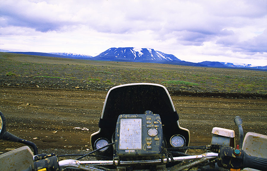
But nothing lives forever, my old garmin before it died (after 90kkm):
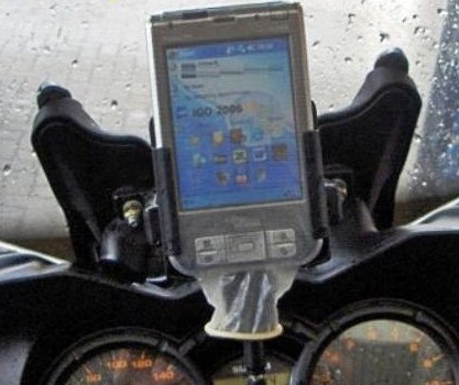
or the alternative 
|
25 Sep 2014
|
|
Registered Users
Veteran HUBBer
|
|
Join Date: Aug 2005
Location: Calgary AB
Posts: 1,032
|
|
|
What do you mean by projecting waypoints and make off-road routes?
My phones last that long typically. But must people upgrade anyway before that.
|
25 Sep 2014
|
|
Registered Users
Veteran HUBBer
|
|
Join Date: Apr 2008
Location: West Yorkshire UK
Posts: 1,785
|
|
Quote:
Originally Posted by AliBaba

or the alternative
|
More multi-use kit! (I hear you can carry water this way too)
Andy
|
25 Sep 2014
|
|
Registered Users
Veteran HUBBer
|
|
Join Date: Apr 2001
Location: Norway
Posts: 1,379
|
|
Quote:
Originally Posted by tmotten
What do you mean by projecting waypoints.....
|
Projecting waypoints is a technique where you can make new waypoints based on an existing waypoint and distance and bearing to the next waypoint.
This is useful if you have the road/route is on your paper-map but not on the GPS. You can then make waypoints for your entire route and connect them together in an offroad-route (next subject).
A similar technique make it possible to backtrack your current location to the paper-map. This is very useful to doublecheck that you are on the right track/direction.
With MY smartphone it's not possible to project waypoints or even make a waypoint based on known coordinates. (some maps have coordinates and some literature also use coordinates (like Sahara Overland and Dürch Africa),
With my GPS I can make waypoints for the entire map if I know one location (typically an intersection).
Quote:
Originally Posted by tmotten
and make off-road routes?
|
An off-road route is a route that consists of straight lines between waypoints.
Used together with "projecting waypoints" (or waypoints from other sources like google-map, literature, friends etc) this give you a pretty good route even if you GPS doesn't show any roads. I find that the route typically gets 20% shorter then in real life, but at least it gives me some information about length and I can calculate need for food, water, petrol and if I need to spend a night or more on my way. You will also get other information like ETA, VMG etc. Off course the quality of this data depends on your waypoints etc.
Another use for off-road route is "combined routes", here you mix ordinary routes and offroad-routes.
Lets say that your route has a part where there is no road. Then you can start by making a ordinary route, swith to off.road mode to make the parts with no roads and then back to ordinary mode. Everything is stored as one route.
With MY phone, which only can make ordinary routes, I have to make one route for the first part, no route for the second part and another route for the last part.
All this complaints are about software. Maybe some of the issues are solved on other phones or they can be solved by free apps. As I sad I search for apps, yesterday with minor luck.
For me it doesn't help if an app is free if it doesn't work properly or I need to spend a lot of time finding it. Time is money!
Another thing is to trust code where you don't know anything about the development (50% of my work consists of developing software). I have also had apps that stopped to work after a while...
In my car I only drive on roads (hopefully) and my phone works great!
Quote:
Originally Posted by tmotten
My phones last that long typically. But must people upgrade anyway before that.
|
Yes, I'm hard on equipment....
As a rule of thumb I would say that marine electronics (so far I've only used marine equipment, right now 276C) has higher standard then consumer electronics.
I still have routes and tracks available for my GPS that I stored back in 1999 (on floppy-disks). I don't think my phone knows what a track is.
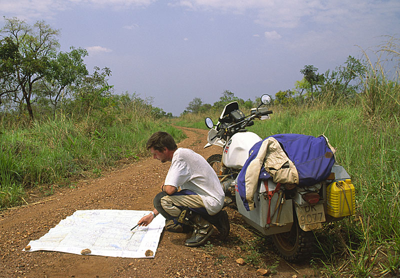
Getting waypoints in Uganda:
|
25 Sep 2014
|
|
Registered Users
Veteran HUBBer
|
|
Join Date: Aug 2005
Location: Calgary AB
Posts: 1,032
|
|
|
Ok, I think I get it, but isn't that 1990's use of a GPS? Wouldn't it be "better" to see yourself projected with an arrow symbol on a topo map that you use to find waypoints?
I don't navigate like that anymore but backcountry navigator has a compass view where you see the direction of the waypoint on it to travel to in a straight line. But on another view in that app you can see yourself and the trail you've done on the topo, so I don't see the need for it myself so can't tell you how good or bad it works. Not sure if you can link multiple waypoints to make a "join the dots" trail.
There are plenty of ways to protect any digital advice. Yo to the user how far he takes it. There are also supposed bomb proof android phones by niche brands. But if you can't luebe with dealing with a Tonka looking phone in normal use it may not be that useful.
|
26 Sep 2014
|
|
Moderated Users
Veteran HUBBer
|
|
Join Date: Oct 2010
Location: Seoul/Yang Pyung
Posts: 545
|
|
Quote:
Originally Posted by tmotten
Ok, I think I get it, but isn't that 1990's use of a GPS? Wouldn't it be "better" to see yourself projected with an arrow symbol on a topo map that you use to find waypoints?
I don't navigate like that anymore but backcountry navigator has a compass view where you see the direction of the waypoint on it to travel to in a straight line. But on another view in that app you can see yourself and the trail you've done on the topo, so I don't see the need for it myself so can't tell you how good or bad it works. Not sure if you can link multiple waypoints to make a "join the dots" trail.
There are plenty of ways to protect any digital advice. Yo to the user how far he takes it. There are also supposed bomb proof android phones by niche brands. But if you can't luebe with dealing with a Tonka looking phone in normal use it may not be that useful.
|
Baba,,
Even using simple Sygic road map ,, I've found your solution by inserting projected waypoints, enroute to my final destination. You simply add the files and the software will route you through the waypoints,, Sygic is offline gps.
Also reading ,,, following programs also allows you to plan off line
and project waypoints as you said.
PathAway GPS Outdoor Navigation
http://backcountrynavigator.com/topographical-gps/
|
26 Sep 2014
|
|
Gold Member
Veteran HUBBer
|
|
Join Date: Jan 2002
Location: Toronto, Canada
Posts: 2,125
|
|
The title of this thread, and the original subject of the discussion, is "Smart Phone vs. dedicated GPS Navigator". I've paraphrased that a little bit in an attempt to return the focus of the discussion to this topic.
In my life, I've done a lot of navigation (I'm a retired aircraft pilot who primarily worked in lesser developed countries), and I've also done a lot of navigation system development (I beta-tested Garmin GPSRs on motorcycles for 6 years from 2001 to 2007, then headed up development of a complete avionics/navigation/flight management system design for a 19 seat commuter aircraft).
I think that the key issue in this discussion should be "horses for courses". There is a huge difference in philosophy and in application between a GPS navigator and a device that will display cartographic information. The two devices do different things and serve different purposes. There is a little bit of overlap, and that overlap is growing slowly as technology advances, but fundamentally, we're talking about two different things here.
Smartphones (or tablets, same concept) can display cartography, and they can do that very well. The cartography can be raster based or vector based. Most of the open-source vector based cartography (e.g. OSM) does not contain road attributes. Road attributes include minutia such as number of lanes, lane width, time of day restrictions, turn restrictions, presence of medians, vehicle restrictions (e.g. weight or width restrictions), and so forth.
None of the above is needed if the rider (or driver) is willing to do their own pilotage (navigation) as they go along, using the smartphone and open source cartography as an aid to navigation. In lesser developed countries where there are few roads, the value of road attributes to route planning diminishes - heck, just the fact that there is a road, or track, or path there is all one needs or wants to know.
On the other hand, a dedicated GPS Navigator normally uses a proprietary (closed source) cartographic database that contains a tremendous amount of attributes per road - in some cases, up to 60 attributes per road, and often images (facsimiles) of the overhead signs along the road. When used with a road navigation engine (the proprietary software of the navigator manufacturer), the navigation guidance given can be extraordinarily powerful, not only providing turn by turn direction, but also providing real-time traffic status (and traffic avoidance), speed camera warnings, on-the-fly rerouting in case of a turn error by the driver or a detour imposed by construction, and, of course, hundreds of thousands of waypoints along the way such as gas stations, hotels, and street addresses.
I'm primarily a street rider. I have a Honda PanEuropean (not a dirt bike by anyone's measure), and in the past 12 years, I've ridden it the length and breadth of Western and Central Europe, including bits of Asia and North Africa. I would never have done this without a GPS Navigator on my motorcycle.
I plan my routes using paper maps (usually Michelin), then I create routes that I will follow using the GPS Navigator. Sometimes I create these routes on a computer and load them into the navigator, sometimes I create them using the navigator as a stand-alone device.
I then go and ride the route - and enjoy it thoroughly - because I am continually being supplied with turn-by-turn route guidance by the navigator. This leaves me free to concentrate on my riding (safety, etc.), the scenery, the culture around me, and so forth. It's very similar to flying an aircraft when the flight plan has been entered into the Flight Management System prior to engine start. You just follow the prompts, and you are assured you will fly the desired path.
For a rider on a dual-sport or dedicated dirt bike who plans to cross deserts (or maybe just ride off-road in fully developed countries), a GPS navigator that uses only proprietary road navigation databases is of little use. But, position confirmation and immediate access to cartography (most especially if the 'own ship' position is plotted on top of the cartography) is extremely important. Smartphones or tablets and open source cartography can fulfill this need very nicely.
The more complex the road environment becomes - for example, in urban areas, or even on highways in countries where the rider is not familiar with the language (or perhaps even not familiar with the script used to write the local language), the greater the value of a GPS navigator.
Likewise, the more remote the environment becomes, in areas where there are few roads and few landmarks, the greater the value of multiple sources of cartography in its various forms (topographic, street mapping, even air photo based) becomes.
I think there are darn few riders out there who would attempt to cross a desert with only a dedicated GPS navigator running a proprietary database. But, by the same token, I think there are darn few riders out there who would suggest that anyone (street or dual-sport rider) attempt to navigate to a specific location in a large city using only cartography, without turn-by-turn guidance from a powerful and purpose-specific GPS navigation engine, based on a detailed database that contains as many road attributes as possible.
In summary: There's no clear winner in this comparison. We should use whatever technology makes the most sense and is most appropriate for the kind of riding we plan to do.
---------------------------------------------------------------------------
On a related matter:
SeoulJoe, you have been dominating this discussion by continually beating your drum and grinding your axe against Garmin. In post #207 above, our forum moderator Bertrand wrote (my bold):
Quote:
Originally Posted by Bertrand
It is clear that you, for some unknown reason, dislike Garmin. This is your choice and your right. You have posted obsessively on that subject for a long time ‘ad nauseatum’ and it really serves no purpose.
It would greatly help others if you could refrain from this from now on and avoid posting misleading information driven by your above feeling. Allow others to draw their own conclusions based on objective and impartial reviews. It is important to provide as accurate information as possible.
|
Please, back off, and recognize that there is no "right or wrong" in this discussion. In particular, stick to the subject at hand, and don't post ad hominem responses to others.
Michael
Last edited by PanEuropean; 26 Sep 2014 at 02:38.
Reason: typo
|
26 Sep 2014
|
|
Registered Users
Veteran HUBBer
|
|
Join Date: Aug 2005
Location: Calgary AB
Posts: 1,032
|
|
|
Good post but I disagree with your statement that a phone can't achieve the same results in urban areas as a dedicated GPS and it makes me think you haven't been following this thread at all or read over it.
Online and offline I use my phone for this constantly without failure.
In the Backcountry it's brilliant with the cartography as you described. Now with dedicated GPS having similar hardware as currently used in smartphones the only value would the maps that you suggested. But this was never great on dedicated units to begin with. With the introduction of GPS in mass market devices like the smartphone development in alternatives has skyrocketed to the point that is no longer the case.
There seem to be 2 different camps that argue against the smartphone as a replacement of a dedicated GPS. One saying it's no good in the backcountry with cartography, the other saying it is but it sucks with road navigation and turn turn. So the Garmin crowd can't seem to agree on its use and strong points.
Both arguments have been extensively covered and countered.
Hardware concerns have also been addressed.
It seems, by the recurring criticisms, that the valid responses to those criticisms are being ignored. Rather than keeping going with the same old invalid or discounted arguments, it may be more constructive to ask how a certain requirement could be achieved without a dedicated GPS. There are plenty of threads discussing what can be done with one. This one is or has become about doing it with something that you already have and use daily.
I find the criticism of the OP becoming increasingly offensive myself as it's moving towards calls for the OP to back off from his own thread which he had been keeping updated and factual, of which there have been positive responses. What's that all about. If ur would be misleading BS would be one thing. But this isn't. If you don't like it don't look at it.
|
26 Sep 2014
|
|
Moderated Users
Veteran HUBBer
|
|
Join Date: Oct 2010
Location: Seoul/Yang Pyung
Posts: 545
|
|
|
PanEuropean ,, glad to have some one knowledgable on the subject join us,,
My hominem responses are backed by an intellectual analysys of several garmins, in many regions of the world, And yes everything in Korea costs 3 - 400% more than say USA or EEC ,, I have lost huge amount of good money ,, being abused by the garmin ,, I wrote about that in earlier posts.
CEO being a Taiwanese ,, all repairs are shipped to Taiwan,,, ( In Asia) we pay for the DHL charge of USD 90 per incident ,, then we have to pay USD 399 to add a Korean keyboard to the garmin software, On top of all this,, units has failed me and others miserably. Not to add the cost of the maps they sell.
This board is to get away from the monopoly of garmin and gain the freedom by using smartphones.
I also am a dedicated street rider ,, using my Harley Davidson Road King ,, had Sygic ,, in Europe ,, Asia ,, Australiasia ,, Russia ,, USA and South America. Both rural and urban settings ,, my smartphone connected with satts faster than the garmin,, even shows me how many satts and where ,,, Sygic comes with thousands of POI from camp sites to cigarette vendors. For adventure riders to Gobi and Uganda ,, you have other choice APPs ,, that details immense amount of info. Yes most cases for FREE. (Motels in Russia really helped,, thousands of them)
Yes I attack garmin ,, because I have been ripped off by them. Yes I am argumentive because ,, I truly believe we ,, motorcycle riders can benefit from using smartphones.
It seems ,, you have not been reading our arguments , rather paying more attention to my personality.
Explore the avaliable apps ,, see our logic behind our debate ,, look at the harware choices, from SATT phone attachement to good cameras.
If you look at the screen shot of this thread ,, Navigation + Maps,, already words mentioning Android ,, smartphone,, Ericsson,, Maps With Me ,, are taking up at least 30% of the sound bite.
Forget my hominemness ,,
Rather wonder if this thread is being sponsored by the Messrs; garmin
|
|
Currently Active Users Viewing This Thread: 7 (0 Registered Users and/or Members and 7 guests)
|
|
|
 Posting Rules
|
You may not post new threads
You may not post replies
You may not post attachments
You may not edit your posts
HTML code is Off
|
|
|
|

Check the RAW segments; Grant, your HU host is on every month!
Episodes below to listen to while you, err, pretend to do something or other...

2020 Edition of Chris Scott's Adventure Motorcycling Handbook.
"Ultimate global guide for red-blooded bikers planning overseas exploration. Covers choice & preparation of best bike, shipping overseas, baggage design, riding techniques, travel health, visas, documentation, safety and useful addresses." Recommended. (Grant)

Ripcord Rescue Travel Insurance™ combines into a single integrated program the best evacuation and rescue with the premier travel insurance coverages designed for adventurers.
Led by special operations veterans, Stanford Medicine affiliated physicians, paramedics and other travel experts, Ripcord is perfect for adventure seekers, climbers, skiers, sports enthusiasts, hunters, international travelers, humanitarian efforts, expeditions and more.
Ripcord travel protection is now available for ALL nationalities, and travel is covered on motorcycles of all sizes!
What others say about HU...
"This site is the BIBLE for international bike travelers." Greg, Australia
"Thank you! The web site, The travels, The insight, The inspiration, Everything, just thanks." Colin, UK
"My friend and I are planning a trip from Singapore to England... We found (the HU) site invaluable as an aid to planning and have based a lot of our purchases (bikes, riding gear, etc.) on what we have learned from this site." Phil, Australia
"I for one always had an adventurous spirit, but you and Susan lit the fire for my trip and I'll be forever grateful for what you two do to inspire others to just do it." Brent, USA
"Your website is a mecca of valuable information and the (video) series is informative, entertaining, and inspiring!" Jennifer, Canada
"Your worldwide organisation and events are the Go To places to for all serious touring and aspiring touring bikers." Trevor, South Africa
"This is the answer to all my questions." Haydn, Australia
"Keep going the excellent work you are doing for Horizons Unlimited - I love it!" Thomas, Germany
Lots more comments here!

Diaries of a compulsive traveller
by Graham Field
Book, eBook, Audiobook
"A compelling, honest, inspiring and entertaining writing style with a built-in feel-good factor" Get them NOW from the authors' website and Amazon.com, Amazon.ca, Amazon.co.uk.
Back Road Map Books and Backroad GPS Maps for all of Canada - a must have!
New to Horizons Unlimited?
New to motorcycle travelling? New to the HU site? Confused? Too many options? It's really very simple - just 4 easy steps!
Horizons Unlimited was founded in 1997 by Grant and Susan Johnson following their journey around the world on a BMW R80G/S.
 Read more about Grant & Susan's story
Membership - help keep us going!
Horizons Unlimited is not a big multi-national company, just two people who love motorcycle travel and have grown what started as a hobby in 1997 into a full time job (usually 8-10 hours per day and 7 days a week) and a labour of love. To keep it going and a roof over our heads, we run events all over the world with the help of volunteers; we sell inspirational and informative DVDs; we have a few selected advertisers; and we make a small amount from memberships.
You don't have to be a Member to come to an HU meeting, access the website, or ask questions on the HUBB. What you get for your membership contribution is our sincere gratitude, good karma and knowing that you're helping to keep the motorcycle travel dream alive. Contributing Members and Gold Members do get additional features on the HUBB. Here's a list of all the Member benefits on the HUBB.
|
|
|


 Linear Mode


