 1Likes 1Likes
-
 1
Post By furious
1
Post By furious
 |

3 Mar 2013
|
|
Registered Users
Veteran HUBBer
|
|
Join Date: Oct 2005
Location: Greece
Posts: 109
|
|
|
OSM vs printed maps
I am used to travel without GPS, but now I got one and I loaded different maps to check out their detail. I am interested in Africa and I am looking for dirt roads or small paved roads. So, that's what I want from my maps and that's what I compared here.
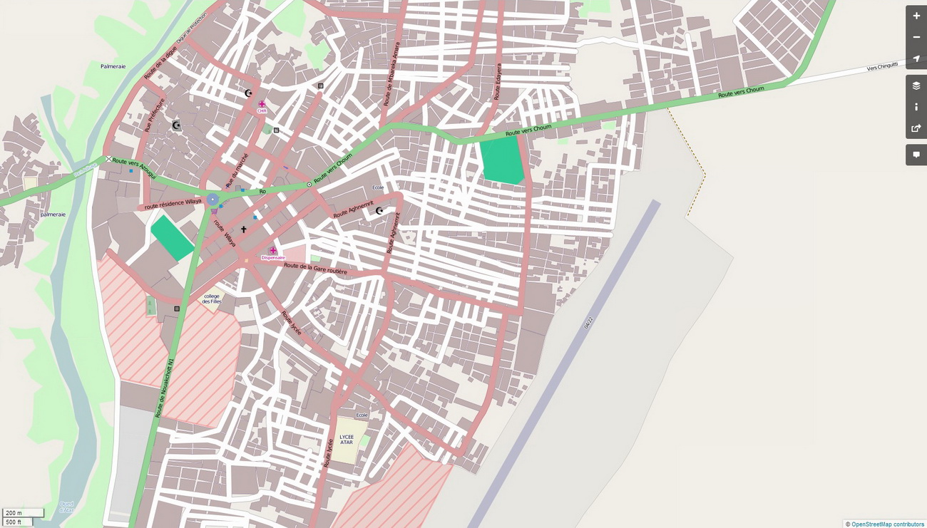
Here is a comparison about Mauritania:
Open Street Maps

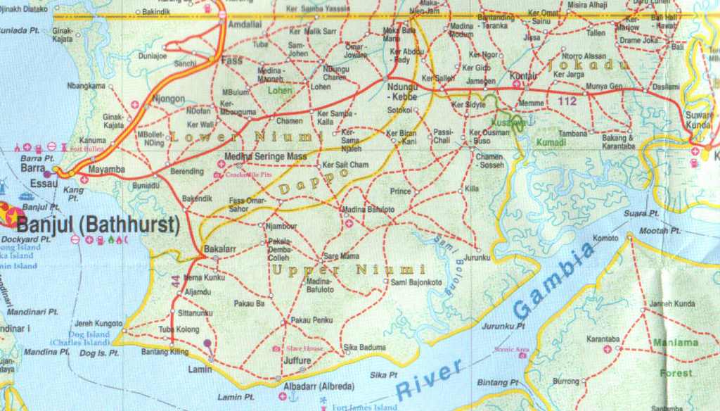
Lonely Planet guide
International Travel Maps

Another comparison about The Gambia:
Open Street Maps
Lonely Planet

International Travel Maps

OSM maps are the most detailed digital maps I found. Still, it's clear that they don't have enough details on Africa. I mean, even Lonely Planet guides, which are not proper maps, are more detailed! So, a good printed map like those from ITMB is invaluable, I think, if you really need some detail.
Except for Olaf's Morocco map, I didn't find any other digital map which is detailed enough to replace my printed maps. I know it's a pain to carry printed maps for some 40 countries, but I think it's very rewarding if you are looking for a lot of off-roading. I am planning to carry about 10 maps at a time and get the rest when I get a parcel from home.
That's not to blame OSM maps. OSM maps are made by people like us, anyway. Sure I want to contribute with my traces and make OSM maps even better.
If you know any other digital map which is more detailed on Africa, please, suggest it.
Cheers!
|
3 Mar 2013
|
|
Registered Users
Veteran HUBBer
|
|
Join Date: Oct 2004
Location: London
Posts: 542
|
|
|
Tracks 4 Africa has detailed track coverage for GPS across Africa, although it is significantly better in southern and east Africa then for the north west.
The alternative, particularly if you want tracks in Mauritiania, is to add the GPS points from a guidebook to create your own routes. You could try either Chris Scott's Sahara Overland or Mauritanie au GPS by Cyril Ribas.
|
5 Mar 2013
|
|
Registered Users
Veteran HUBBer
|
|
Join Date: Oct 2005
Location: Greece
Posts: 109
|
|
Quote:
Originally Posted by Matt Roach

Tracks 4 Africa has detailed track coverage for GPS across Africa, although it is significantly better in southern and east Africa then for the north west.
The alternative, particularly if you want tracks in Mauritiania, is to add the GPS points from a guidebook to create your own routes. You could try either Chris Scott's Sahara Overland or Mauritanie au GPS by Cyril Ribas.
|
Yes, I got Sahara Overland and it's a treasure! I'll add the waypoints to my GPS and carry those pages with me. Are those tracks available in digital format or should I add manually the waypoints written in the book?
I am considering to use T4A, but I read in another post that their detail is similar to OSM. Maybe I 'll have the chance to compare them.
|
6 Mar 2013
|
|
Registered Users
Veteran HUBBer
|
|
Join Date: Apr 2005
Location: Oxford UK
Posts: 2,104
|
|
Depends what GPS you're using but my answer has been to put the digital versions of the IGN maps for West Africa on a pda running Ozi Explorer. It's all a bit "old skool" now - I set it all up about six or seven years ago, so there's no routing or anything but you do get a large red arrow pointing to "you are here" and the IGN maps have a lot more detail than any of the map samples above.
|
14 Mar 2013
|
|
Registered Users
Veteran HUBBer
|
|
Join Date: Apr 2001
Location: Scotland
Posts: 775
|
|
Pda? Now, that's OLD SKOOL! 
Open Street Maps seem to be what the name implores - street maps where there are no streets. I have discovered that for North Africa the old Russian military maps scanned and calibrated with OE or TTQV work quite well. They may be 50 years old, but it means little where you are going.
__________________
----------------
Roman (UK)
|
29 Mar 2013
|
|
Registered Users
Veteran HUBBer
|
|
Join Date: Oct 2005
Location: Greece
Posts: 109
|
|
|
After having checked some more digital maps, I have to say that the Garmin City Navigator Pan-Africa NTU has much better detail than OSM. Actually, their detail is almost as good as in my printed maps.
For the southern Africa, Tracks4Africa are very detailed too!
|
9 Sep 2013
|
|
Registered Users
Veteran HUBBer
|
|
Join Date: Feb 2004
Location: UK
Posts: 1,232
|
|
have just downloaded Russian military maps from android store, some good topographical info, obviously the routes won't be showing all the new Chinese roads!!
|
10 Sep 2013
|
|
Banned
Veteran HUBBer
|
|
Join Date: Dec 2009
Posts: 973
|
|
|
|
11 Sep 2013
|
 |
Registered Users
Veteran HUBBer
|
|
Join Date: Nov 2004
Location: London / Moscow
Posts: 1,913
|
|
Quote:
Originally Posted by furious
OSM maps are the most detailed digital maps I found. Still, it's clear that they don't have enough details on Africa. I mean, even Lonely Planet guides, which are not proper maps, are more detailed!
|
Sorry but I have to say, this kinda seems a very irrational comparison. Its like you have hand picked the examples to tell the story you wanted to tell rather than offering meaningful comparisons. You have simply focused on the areas where lonely planet has detailed printed maps ... which are for a tiny selection of a continent.
You seem to have deliberately used the wrong level of zoom / detail. You see one important detail you didnt mention about paper maps, is that you cant zoom in on them. Thats why electronic maps offer lower detail at greater zoom out. ... so as not to clutter the screen. If you want more detail you just zoom in.
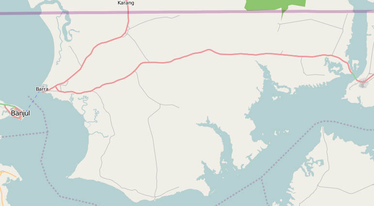
For example, your OSM picture of the Banjul area ... if you zoomed in one more click, you get a similar amount of detail:
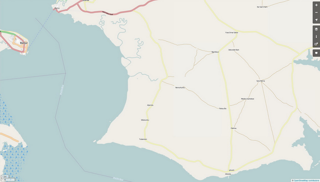
You simply cant compare detail from paper maps with electronic maps at a similar level of zoom. Paper maps cant be zoomed, so they put as much detail as possible on the one layer. Electronic maps can be zoomed, therefore more detail is available as you zoom in. They are deliberately designed to be uncluttered! You cant compare the two at a simple single level of zoom. Electronic maps and paper maps present information very differently. They are not the same animal.
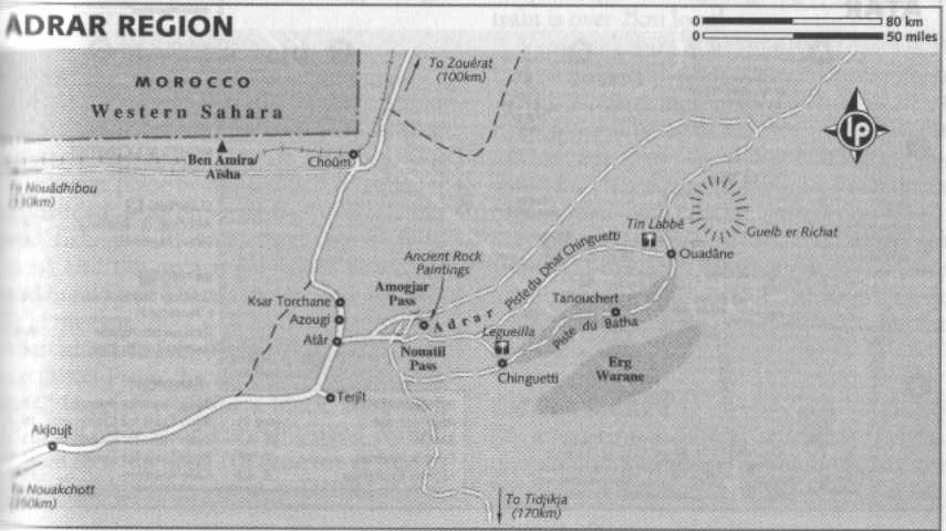
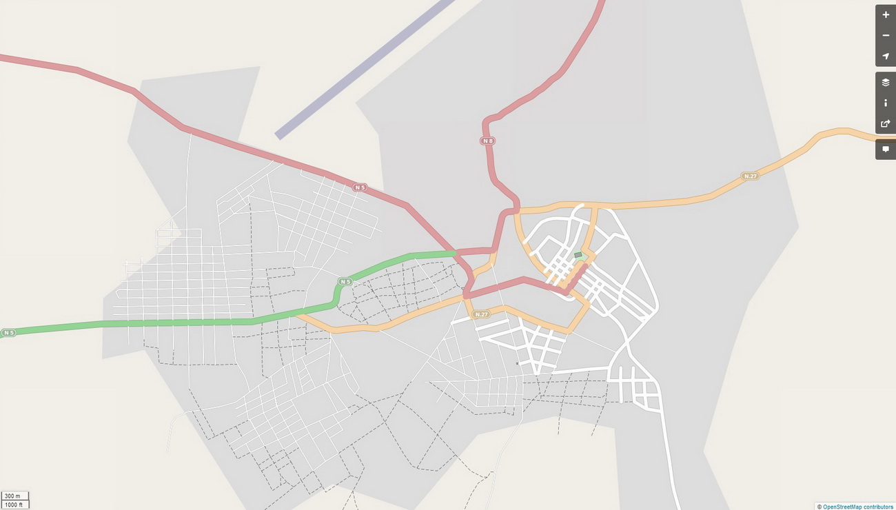
And only comparing the areas where lonely planet actually has maps isnt a rational comparison either ... I mean does lonely planet offer you this detail ... (the next two maps are kinda important in the comparison of paper vs electronic maps of the Adrar region)
Of Atar?
Of Chinguetti?
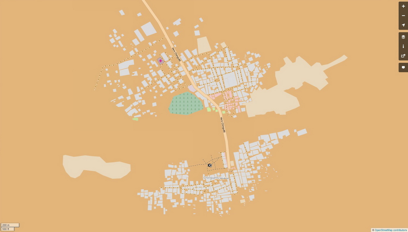
You only offered the zoomed out OSM map below in your Mauritania comparison, and didnt offer the additional info in the forms of the maps above ... which is kinda important in judging the level of detail offered by OSM in comparison with the other two sources, isnt it?:
Quote:
Originally Posted by furious
Here is a comparison about Mauritania:
Open Street Maps
|
- - -
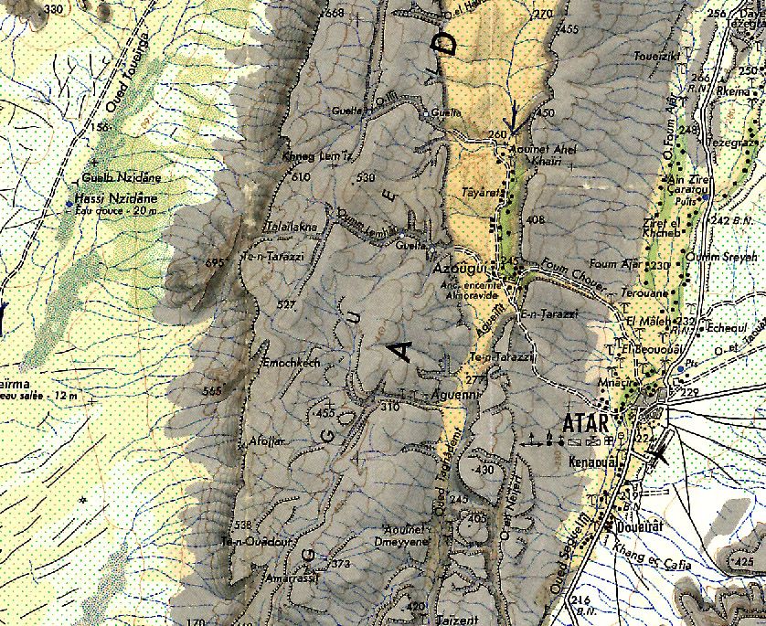
I can turn your argument on its head by saying: look at the these two comparisons of the Atar region ... which is more detailed ??
Lonely Planet guide
or OSM
- - -
Lets pick a random spot in Africa ... what does Lonely Planet offer in terms of maps of Labe in Guinea?
I bet there are tens of thousands of areas in Africa where OSM is more detailed than Lonely Planet, or where Lonely Planet have no maps at all. Just about every village in fact. Your method of comparison is just not logical. The conclusion that Lonely Planet maps are more detailed, for Africa as a whole (as opposed to a hand selected handful of locations), is absolutely unsustainable.
|
12 Sep 2013
|
|
Registered Users
Veteran HUBBer
|
|
Join Date: Aug 2012
Location: Australia
Posts: 1,131
|
|
|
The garmin maps have up to 8 levels of 'zoom' detail (probably other vector maps too) ... so you can say it may be equal to 8 different paper maps. Of course the most detailed equivalent map will be way too large to open out .. think foot ball field size. Similar to Photoshop with its layers or other cad packages, much more can be done on the computer compared to the old paper systems.
|
16 Sep 2013
|
|
Registered Users
Veteran HUBBer
|
|
Join Date: Oct 2005
Location: Greece
Posts: 109
|
|
Hi Colebatch!
What you say about the zoom level is obvious. I am sorry I didn't use the most detailed image of OSM, but still the two maps below don't seem to me to have similar detail:
And of course, I agree with your comments about Lonely Planet. As I wrote in my initial post, Lonely Planet guides are not proper maps. The thread title and the comparison I was doing was between OSM maps and printed maps, NOT Lonely Planet travel guides!
Ride safe!
|
16 Sep 2013
|
|
Registered Users
Veteran HUBBer
|
|
Join Date: Aug 2012
Location: Australia
Posts: 1,131
|
|
Quote:
Originally Posted by furious
Hi Colebatch!
What you say about the zoom level is obvious. I am sorry I didn't use the most detailed image of OSM, but still the two maps below don't seem to me to have similar detail:
|
Ok. It is not easy to do a comparison for 'detail' unless you fully zoom in and then that is not fair for a paper map that shows the whole country. Swings and roundabouts.
The GPS map display - you can set the level of detail from low to highest ... and some have a 'declutter' button.
The GPS map designer has a number of choices as to what to display at various levels .. too much and you cannot see due to all that stuff, too little and you don't have enough. This is further complicated by the screen size - you can get more on the larger screen of a home PC compared to a 1" x 2" screen... The designer can chose to have dirt roads show up fairly early or not. Most people are not interested in the dirt roads so most designers chose to hide the dirt roads until you are zoomed in a lot. On the other hand Tracks 4 Australia places the major dirt roads well up in comparison to City Navigator Australia, different 'markets' so they do things differently.
I use both types (vector [what most would call GPS] and raster [what most would call paper]) of maps - though I tend to scan the paper map into a computer and use Oziexplorer to do things GPS with it. I can even convert it to a vector map - but that is a lot of work so it does not happen often.
|
17 Sep 2013
|
|
Registered Users
Veteran HUBBer
|
|
Join Date: Aug 2005
Location: Calgary AB
Posts: 1,032
|
|
|
This debate digital vs paper is a bit silly. Maps are about content, not the media it is shown on. Just buy the paper version in a digital format or scan it. Problem solved.
|
|
Currently Active Users Viewing This Thread: 1 (0 Registered Users and/or Members and 1 guests)
|
|
|
 Posting Rules
|
You may not post new threads
You may not post replies
You may not post attachments
You may not edit your posts
HTML code is Off
|
|
|
|

Check the RAW segments; Grant, your HU host is on every month!
Episodes below to listen to while you, err, pretend to do something or other...

2020 Edition of Chris Scott's Adventure Motorcycling Handbook.
"Ultimate global guide for red-blooded bikers planning overseas exploration. Covers choice & preparation of best bike, shipping overseas, baggage design, riding techniques, travel health, visas, documentation, safety and useful addresses." Recommended. (Grant)

Ripcord Rescue Travel Insurance™ combines into a single integrated program the best evacuation and rescue with the premier travel insurance coverages designed for adventurers.
Led by special operations veterans, Stanford Medicine affiliated physicians, paramedics and other travel experts, Ripcord is perfect for adventure seekers, climbers, skiers, sports enthusiasts, hunters, international travelers, humanitarian efforts, expeditions and more.
Ripcord travel protection is now available for ALL nationalities, and travel is covered on motorcycles of all sizes!
What others say about HU...
"This site is the BIBLE for international bike travelers." Greg, Australia
"Thank you! The web site, The travels, The insight, The inspiration, Everything, just thanks." Colin, UK
"My friend and I are planning a trip from Singapore to England... We found (the HU) site invaluable as an aid to planning and have based a lot of our purchases (bikes, riding gear, etc.) on what we have learned from this site." Phil, Australia
"I for one always had an adventurous spirit, but you and Susan lit the fire for my trip and I'll be forever grateful for what you two do to inspire others to just do it." Brent, USA
"Your website is a mecca of valuable information and the (video) series is informative, entertaining, and inspiring!" Jennifer, Canada
"Your worldwide organisation and events are the Go To places to for all serious touring and aspiring touring bikers." Trevor, South Africa
"This is the answer to all my questions." Haydn, Australia
"Keep going the excellent work you are doing for Horizons Unlimited - I love it!" Thomas, Germany
Lots more comments here!

Diaries of a compulsive traveller
by Graham Field
Book, eBook, Audiobook
"A compelling, honest, inspiring and entertaining writing style with a built-in feel-good factor" Get them NOW from the authors' website and Amazon.com, Amazon.ca, Amazon.co.uk.
Back Road Map Books and Backroad GPS Maps for all of Canada - a must have!
New to Horizons Unlimited?
New to motorcycle travelling? New to the HU site? Confused? Too many options? It's really very simple - just 4 easy steps!
Horizons Unlimited was founded in 1997 by Grant and Susan Johnson following their journey around the world on a BMW R80G/S.
 Read more about Grant & Susan's story
Membership - help keep us going!
Horizons Unlimited is not a big multi-national company, just two people who love motorcycle travel and have grown what started as a hobby in 1997 into a full time job (usually 8-10 hours per day and 7 days a week) and a labour of love. To keep it going and a roof over our heads, we run events all over the world with the help of volunteers; we sell inspirational and informative DVDs; we have a few selected advertisers; and we make a small amount from memberships.
You don't have to be a Member to come to an HU meeting, access the website, or ask questions on the HUBB. What you get for your membership contribution is our sincere gratitude, good karma and knowing that you're helping to keep the motorcycle travel dream alive. Contributing Members and Gold Members do get additional features on the HUBB. Here's a list of all the Member benefits on the HUBB.
|
|
|


 Linear Mode


