 |

20 Nov 2013
|
|
Registered Users
Veteran HUBBer
|
|
Join Date: Jan 2008
Location: Inverness, Scotland
Posts: 249
|
|
|
Garmin Basecamp routing length limitations
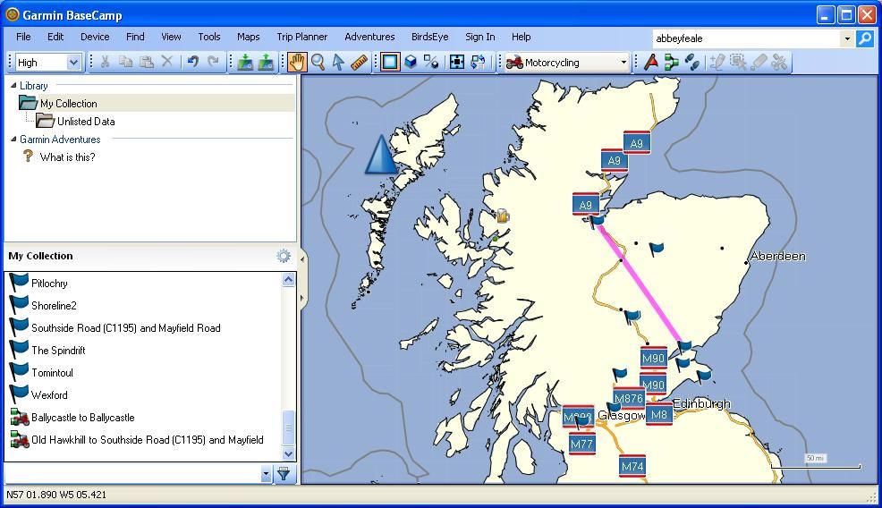
Been a bit puzzled as to why Basecamp has been giving me straight lines across country (as if I'm in a plane) rather than following roads like it should/.
I'm using an OSM routable map and when planning an IBA trip round Ireland (seven waypoints) I noticed that only one section was properly routed- between two waypoints that were relatively close together.
After reinstalling basecamp in case it was corrupted (it wasn't) I tried two routes: Dundee to Tomintoul (about 80 miles) and Dundee to Inverness (about 145miles) and BC failed to plot the longer route, but had no problems with the shorter one (both in the same direction BTW).
Is there an upper limit between waypoints that BC can't cope with? My tests suggest there is, and is there any way of getting round this- online mapping eg Google will calculate a route clear across Europe between two points.
|
20 Nov 2013
|
 |
-
Veteran HUBBer
|
|
Join Date: Apr 2006
Location: WWW
Posts: 2,341
|
|
|
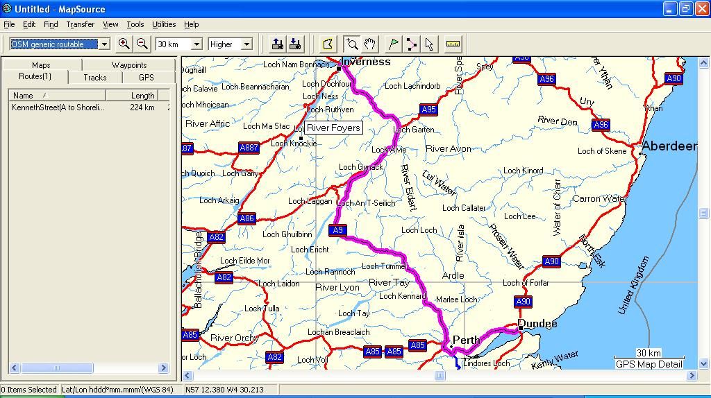
Just tried it
and cannot replicate your problem. I am assuming that you have checked that your routing setting isn't set at 'DIRECT' aka as the crow flies?
see pics
221.62 Kms
Map is OSM downloaded 23 Oct 2013
Click on pics to enlarge
For my sins ( and there are many!) I have never understood the need to plan a single route over huge distances.
Huge routes, when you will take a wrong turn, as you inevitably will, take a loooooong time to recalculate.
IMHO, best practice is to make routes by all means if you want those but keep them short aka a day's average ride.
My 2 pence
Last edited by Bertrand; 2 Mar 2016 at 16:17.
|
20 Nov 2013
|
|
Registered Users
Veteran HUBBer
|
|
Join Date: Jan 2008
Location: Inverness, Scotland
Posts: 249
|
|
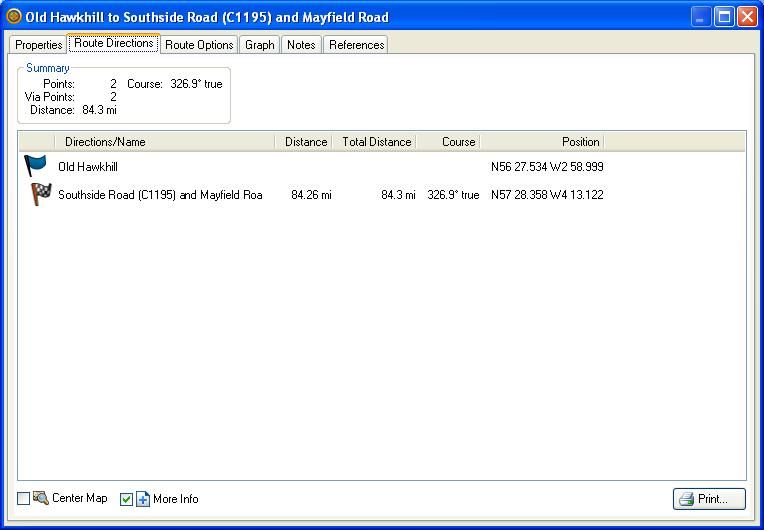
We-e-e-l technically this is a one day route- an Iron Butt ride around Ireland 
I've basically disabled all route avoidances. When I set up the Ireland route it just went point to point in staraight lines apart from one section where the waypoints were quite close together. I've managed to get it to plot a route following the roads now, but I had to add quite a few extra waypoints to make it work. The ride is only 800 odd miles, not here to Magadan!
How do I post screenshots of BC- you might be able to spot what I'm doing wrong.
|
20 Nov 2013
|
|
-
Veteran HUBBer
|
|
Join Date: Apr 2006
Location: WWW
Posts: 2,341
|
|

It is not impossible that there may be a node or three missing in the OSM route which maybe causing a glitch in the calculation.
Try the following:
1- Ensure your version of BC is the latest one
2-Manually create a series of waypoints in BC
3- Create a new route in BC by drag and dropping your points in the routing window and see what transpires.
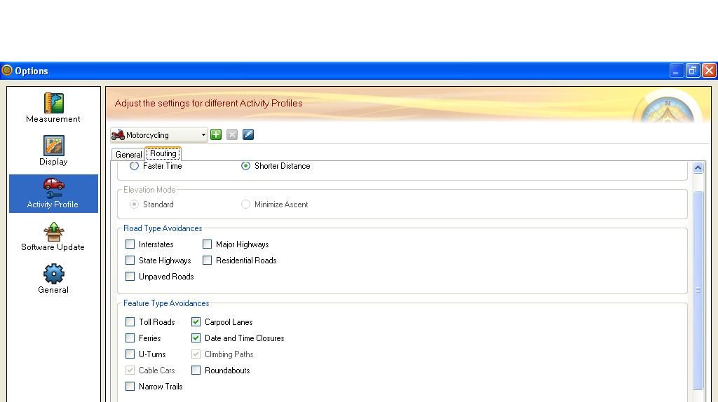
You may want to check the settings in the Motorcycling profile in BC to make sure these match those in your gps.
Shortest, fastest, avoidances etc etc
Soooo many settings!
When BC is running ( or anything other program for that matter, you can take a screen shot of what you see- 2 options - one where you use a rectangle to select an area you wish your image to be or one which takes the whole screen.
Opening (in windows) the resulting image ( Open with option) the little program called 'Paint' enables you to add arrows/lines/text etc etc to your screen shot.
Then you chose ' Go Advanced' and chose 'Manage Attachments'
Select each image then press upload when replying on the Hubb to add images to upload.
Tip - resizing your screenshot image to 800 X 600 size reduces upload time and clutter on HU! 
Why anyone would want to 'iron butt' around Ireland is beyond me! There are so so many simply fabulous places to eat, drink and be merry there! Durty Nellys to mention but one!
Ahhhh fond memories of the Emerald Isle and its fun loving people. (except that little turnip who insisted I leave the pub at 04:30 really.... !!  )
Durty Nellys is here 52.696387,-8.811943
Last edited by Bertrand; 20 Nov 2013 at 18:08.
Reason: added Coords
|
20 Nov 2013
|
|
Registered Users
Veteran HUBBer
|
|
Join Date: Jan 2008
Location: Inverness, Scotland
Posts: 249
|
|
One straight line using waypoints I already had...
Settings
|
20 Nov 2013
|
|
Registered Users
New on the HUBB
|
|
Join Date: May 2009
Location: Ireland
Posts: 8
|
|
|
Its a common problem with OSM mapping. I use Map-source and can get the straight line routing at times. Solution as you have found is to put in more route shaping way-points and everything will work fine, if it does not always work on some segments you will find a break in the road somewhere on tight zoom in.
|
20 Nov 2013
|
|
Registered Users
Veteran HUBBer
|
|
Join Date: Jan 2008
Location: Inverness, Scotland
Posts: 249
|
|
Seems to work fine in Mapsource. Bit irritating when the all singing and dancing newer product doesn't seem to work!
|
20 Nov 2013
|
|
Registered Users
New on the HUBB
|
|
Join Date: May 2009
Location: Ireland
Posts: 8
|
|
|
Have to say, I much prefer using Map-source to Base-camp any time.
|
20 Nov 2013
|
|
Registered Users
Veteran HUBBer
|
|
Join Date: Jan 2008
Location: Inverness, Scotland
Posts: 249
|
|
|
Tried to do the Ireland one in Mapsource and it's also misbehaving, although not as much as Basecamp. Looks like there is an issue with the map. I download from the one mentioned by Colebatch in the OSM thread- is there a better (or at least, different) one to try?
|
20 Nov 2013
|
|
Registered Users
New on the HUBB
|
|
Join Date: May 2009
Location: Ireland
Posts: 8
|
|
Presume this is where your getting your maps.....
Free worldwide Garmin maps from OpenStreetMap
Works fine for me in Map-source.....most of the time !
|
20 Nov 2013
|
|
Registered Users
Veteran HUBBer
|
|
Join Date: Jan 2008
Location: Inverness, Scotland
Posts: 249
|
|
|
Yep, that's the one. Guess I'll just have to ease off on the distances between waypoints. Ho hum.
|
21 Nov 2013
|
|
-
Veteran HUBBer
|
|
Join Date: Apr 2006
Location: WWW
Posts: 2,341
|
|
There is no reason why it should not work Reggie. I've demonstrated above that it does.
May I suggest you spend a little timer reading this? I think it may help you.
|
21 Nov 2013
|
|
Registered Users
Veteran HUBBer
|
|
Join Date: Jan 2008
Location: Inverness, Scotland
Posts: 249
|
|
|
Thanks Bertrand. Had seen that before, and I needed reminding of the snap tool which certainly helps a great deal. Too many bloody devices to try to remember...
|
15 Dec 2013
|
|
Registered Users
HUBB regular
|
|
Join Date: Dec 2013
Location: Edmonton
Posts: 36
|
|
|
Take a look at this tutorial on BaseCamp.
[url=http://forums.delphiforums.com/n/main.asp?webtag=GarminBasecamp&nav=start&prettyurl =%2FGarminBasecamp&gid=2060536750]Delphi Forums Login
|
|
Currently Active Users Viewing This Thread: 1 (0 Registered Users and/or Members and 1 guests)
|
|
|
 Posting Rules
|
You may not post new threads
You may not post replies
You may not post attachments
You may not edit your posts
HTML code is Off
|
|
|
 Similar Threads
|
| Thread |
Thread Starter |
Forum |
Replies |
Last Post |
|
Garmin GPSMAP 278 (Boxed) + Touratech Mounts x 2 - For sale UK
|
Jerome |
TRAVEL Equipment for Sale / Wanted |
4 |
28 Aug 2013 08:30 |
|
Best VFM Garmin GPS
|
Walkabout |
Navigation - Maps, Compass, GPS |
41 |
22 Apr 2013 14:28 |
|
Tracks 4 Africa on my Garmin.. A couple of questions
|
ajctraveler |
Navigation - Maps, Compass, GPS |
14 |
24 Feb 2013 09:34 |
|
Review Garmin Zumo 220 GPS
|
mmaarten |
Navigation - Maps, Compass, GPS |
1 |
24 Feb 2013 09:18 |
|
Offroad/Good Road routes Slovenia, Croatia, Bosnia, Albania, Macedonia
|
Sixtring74 |
Route Planning |
5 |
9 Nov 2012 13:20 |
|

Check the RAW segments; Grant, your HU host is on every month!
Episodes below to listen to while you, err, pretend to do something or other...

2020 Edition of Chris Scott's Adventure Motorcycling Handbook.
"Ultimate global guide for red-blooded bikers planning overseas exploration. Covers choice & preparation of best bike, shipping overseas, baggage design, riding techniques, travel health, visas, documentation, safety and useful addresses." Recommended. (Grant)

Ripcord Rescue Travel Insurance™ combines into a single integrated program the best evacuation and rescue with the premier travel insurance coverages designed for adventurers.
Led by special operations veterans, Stanford Medicine affiliated physicians, paramedics and other travel experts, Ripcord is perfect for adventure seekers, climbers, skiers, sports enthusiasts, hunters, international travelers, humanitarian efforts, expeditions and more.
Ripcord travel protection is now available for ALL nationalities, and travel is covered on motorcycles of all sizes!
What others say about HU...
"This site is the BIBLE for international bike travelers." Greg, Australia
"Thank you! The web site, The travels, The insight, The inspiration, Everything, just thanks." Colin, UK
"My friend and I are planning a trip from Singapore to England... We found (the HU) site invaluable as an aid to planning and have based a lot of our purchases (bikes, riding gear, etc.) on what we have learned from this site." Phil, Australia
"I for one always had an adventurous spirit, but you and Susan lit the fire for my trip and I'll be forever grateful for what you two do to inspire others to just do it." Brent, USA
"Your website is a mecca of valuable information and the (video) series is informative, entertaining, and inspiring!" Jennifer, Canada
"Your worldwide organisation and events are the Go To places to for all serious touring and aspiring touring bikers." Trevor, South Africa
"This is the answer to all my questions." Haydn, Australia
"Keep going the excellent work you are doing for Horizons Unlimited - I love it!" Thomas, Germany
Lots more comments here!

Diaries of a compulsive traveller
by Graham Field
Book, eBook, Audiobook
"A compelling, honest, inspiring and entertaining writing style with a built-in feel-good factor" Get them NOW from the authors' website and Amazon.com, Amazon.ca, Amazon.co.uk.
Back Road Map Books and Backroad GPS Maps for all of Canada - a must have!
New to Horizons Unlimited?
New to motorcycle travelling? New to the HU site? Confused? Too many options? It's really very simple - just 4 easy steps!
Horizons Unlimited was founded in 1997 by Grant and Susan Johnson following their journey around the world on a BMW R80G/S.
 Read more about Grant & Susan's story
Membership - help keep us going!
Horizons Unlimited is not a big multi-national company, just two people who love motorcycle travel and have grown what started as a hobby in 1997 into a full time job (usually 8-10 hours per day and 7 days a week) and a labour of love. To keep it going and a roof over our heads, we run events all over the world with the help of volunteers; we sell inspirational and informative DVDs; we have a few selected advertisers; and we make a small amount from memberships.
You don't have to be a Member to come to an HU meeting, access the website, or ask questions on the HUBB. What you get for your membership contribution is our sincere gratitude, good karma and knowing that you're helping to keep the motorcycle travel dream alive. Contributing Members and Gold Members do get additional features on the HUBB. Here's a list of all the Member benefits on the HUBB.
|
|
|


 Linear Mode


